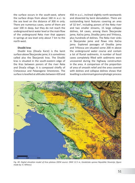
<strong>the</strong> surface occurs in <strong>the</strong> south-west, where<strong>the</strong> surface drops <strong>from</strong> about 160 m a.s.l. to<strong>the</strong> sea level on <strong>the</strong> distance <strong>of</strong> 300 m only.There are numerous caves, some <strong>of</strong> <strong>the</strong>m areover 100 m deep, but <strong>the</strong>y do not reach <strong>the</strong>underground karst water level or <strong>the</strong> main flow<strong>of</strong> <strong>the</strong> underground Reka river that appearsin springs at sea level only about 7 km to <strong>the</strong>north-west.Divaški krasDivaški kras (Divača <strong>Karst</strong>) is <strong>the</strong> karstsurface above Škocjanske jame; it is sometimescalled also <strong>the</strong> Škocjanski kras. The Divaškikras is situated in <strong>the</strong> south-eastern edge <strong>of</strong><strong>the</strong> Kras between ponors <strong>of</strong> <strong>the</strong> river Rekaand Divača village. It is composed chiefly <strong>of</strong>Cretaceous and Palaeogene limestones. Thesurface is levelled at altitudes between 420 and450 m a.s.l., inclined slightly north-westwardsand dissected by karst denudation. There areoutstanding karst features covering an area<strong>of</strong> 32 km 2 , including ponors <strong>of</strong> <strong>the</strong> Reka riverand two smaller streams, 15 large collapsedolines, 64 caves, among <strong>the</strong>m Škocjanskejame, Kačna jama, Divaška jama and Trhlovca,plus hundreds <strong>of</strong> dolines. The Reka river sinksin Škocjanske jame and flows into Kačnajama. Explored passages <strong>of</strong> Divaška jamaand Trhlovca are situated some 200 m above<strong>the</strong> underground water course and containa lot <strong>of</strong> fluvial sediments. A number <strong>of</strong> fossilcaves completely filled with sediments wereuncovered during <strong>the</strong> highway constructionin <strong>the</strong> area. A comparison <strong>of</strong> <strong>the</strong> proportion<strong>of</strong> area <strong>of</strong> smooth relief and <strong>the</strong> area coveredwith dolines and collapse dolines shows thatlevelling is a dominant geomorphologic processFig. 40: Digital elevation model <strong>of</strong> Kras plateau (DEM source: DMV 12.5 m, Geodetska uprava Republike Slovenije; figuremade by: A. Mihevc).51
in this part <strong>of</strong> <strong>the</strong> Kras (Mihevc 2001). Theproportional area <strong>of</strong> dolines is low, despite <strong>the</strong>great vertical gradient in karst. In comparisonwith doline surfaces, <strong>the</strong> speleologicalelements (collapse dolines, unro<strong>of</strong>ed caves andcave entrances) are an important part <strong>of</strong> <strong>the</strong>relief. Even more important is <strong>the</strong> proportion<strong>of</strong> speleological elements in karstic relief ifwe compare volumes <strong>of</strong> ordinary dolines andcollapse dolines. Even though <strong>the</strong> areas <strong>of</strong><strong>the</strong> dolines are only twice those <strong>of</strong> collapsedolines, <strong>the</strong> volumes <strong>of</strong> collapse dolines arefive times larger than those <strong>of</strong> collapse dolines.Ljubljanica River SystemThe karst area along underground Ljubljanicariver is important <strong>from</strong> a historicalpoint <strong>of</strong> view because karst hydrology studiesbegun here in <strong>the</strong> 16 th century and numerouskarst features were first described hereand are <strong>the</strong> reference features for <strong>the</strong> similarfeatures elsewhere. Important features <strong>of</strong> <strong>the</strong>Ljubljanica karst are: poljes (Cerkniško polje,Planinsko polje); high karst plateaus (Hrušicaplateau), dolines, collapse dolines, cave systems(Postojnska jama – Planinska jama cavesystem, Križna jama, Rakov Škocjan) and karsthydrology (sinking rivers, ponors, springs,floods; Fig. 41).Ljubljanica River collects <strong>the</strong> water <strong>from</strong>southwest part <strong>of</strong> <strong>the</strong> <strong>Dinaric</strong> karst in <strong>Slovenia</strong>and belongs as right Sava affluent to Danubepart <strong>of</strong> Black Sea water basin. The real watershedis placed somewhere in <strong>the</strong> underground,and <strong>the</strong> waters <strong>from</strong> karst plateauare flowing to all sides. The Ljubljanica waterbasin is about 1,100-1,200 km 2 . The mean annualprecipitation in <strong>the</strong> basin is 1,300-3,000mm, during 100 to 150 rainy days. The one-daymaximal amount to 100 mm, in extreme caseseven 300 mm.Most <strong>of</strong> <strong>the</strong> river basin is formed on Mesozoicrocks, mostly limestone. On <strong>the</strong>se rocks<strong>the</strong> precipitation infiltrates directly into <strong>the</strong>karst and <strong>the</strong>re are no surface rivers. Triassicdolomite is important, allowing some surfaceflow, forming bottoms <strong>of</strong> some karst poljes orforming hydrologic barriers.The highest parts <strong>of</strong> <strong>the</strong> basin are highkarst plateaus Hrušica, Javorniki and Snežnikand Racna gora. On <strong>the</strong> poljes among <strong>the</strong>m,surface rivers appear only, but <strong>the</strong>y have differentnames: Trbuhovica, Obrh, Stržen, Rak,Pivka, Unica and finally after <strong>the</strong> springs at Vrhnika<strong>the</strong> name Ljubljanica. The highest lying is<strong>the</strong> karst polje near Prezid (770 m), followedby Babno polje (750 m), Loško polje (580 m),Cerkniško polje (550 m), Rakov Škocjan andUnško polje (520 m), Planinsko polje (450m),Logaško polje (470 m) and finally LjubljanskoBarje (300 m), where <strong>the</strong> Ljubljanica springsare at 300 m a.s.l. There are several largesprings are dispersed along <strong>the</strong> edge <strong>of</strong> <strong>the</strong>Ljubljana Moor, which is connected with <strong>the</strong>gradual tectonic subsidence <strong>of</strong> <strong>the</strong> area. Meanannual discharge <strong>of</strong> <strong>the</strong> Ljubljanica River at <strong>the</strong>springs is 38.6 m 3 .There are about 1,540 caves, accessiblefragments <strong>of</strong> underground drainage systemknown in <strong>the</strong> catchment area <strong>of</strong> <strong>the</strong> Ljubljanica.Almost fifty kilometres <strong>of</strong> cave passages areknown to exist along significant undergroundwatercourses. The average length <strong>of</strong> <strong>the</strong> caveis 48 m and <strong>the</strong> depth 18 m. However, <strong>the</strong>largest caves are <strong>the</strong> ponor or spring caves;in <strong>the</strong>m we can follow <strong>the</strong> 71 km <strong>of</strong> passages<strong>of</strong> <strong>the</strong> main rivers, tributaries <strong>of</strong> Ljubljanica.Larger caves found in this area include <strong>the</strong> Karlovice,Zelške jame, Tkalca jama, and Planinacaves. In Planina Cave <strong>the</strong>se waters are joinedby <strong>the</strong> Pivka River <strong>from</strong> Postojna Cave. From52
- Page 2 and 3: Andrej Mihevc, Mitja Prelovšek, Na
- Page 4 and 5: ContentsGeographical Position and G
- Page 7 and 8: Fig. 2: Coastal part of Dinaric kar
- Page 9 and 10: ogy started. In 1531 a lawyer from
- Page 11 and 12: include numerous data and general o
- Page 13 and 14: GeologyNadja Zupan HajnaThe Dinaric
- Page 15 and 16: ceous. The final disintegration of
- Page 17 and 18: Fig. 11: Locations of Jelar Breccia
- Page 19 and 20: ClimateMitja PrelovšekThe Dinaric
- Page 21 and 22: 311 mm/a; Zaninović 2008) and incr
- Page 23 and 24: 24Fig. 16: Spatial distribution of
- Page 25 and 26: ocks (such as Eocene flysch, Lower
- Page 27 and 28: absent. Downstreamparts of the cany
- Page 29 and 30: GeomorphologyAndrej MihevcIn folk l
- Page 31 and 32: long. They are smoother especially
- Page 33 and 34: is now depositing. Best known are t
- Page 35 and 36: Structural poljes are dominated by
- Page 37 and 38: Fig. 28: Typical dolines of Dinaric
- Page 39 and 40: the disintegrated collapsed rock at
- Page 41 and 42: on Northern Velebit, where three ca
- Page 43 and 44: Land UseNadja Zupan Hajna, Andrej M
- Page 45 and 46: for ‘bare limestone desert’ -th
- Page 47 and 48: Fig. 38: Grančarevo dam in the upp
- Page 49: KrasThe Kras is a distinct plateau,
- Page 53 and 54: dolomite barrier along the Idrija w
- Page 55 and 56: of Dolenjska (Gams, 1974; Kranjc, 1
- Page 57 and 58: Fig. 44: Blind valleys of Matarsko
- Page 59 and 60: ly several dozen meters deep. Shaft
- Page 61 and 62: smaller than the higher ones. The r
- Page 63 and 64: tion in the Divaški kras (Mihevc 1
- Page 65 and 66: Use of Karst and its ProtectionThe
- Page 67 and 68: Gams, I., Vrišer, I. (Eds.), 1998:
- Page 69 and 70: lems.- Dela 38, Raziskovalni center