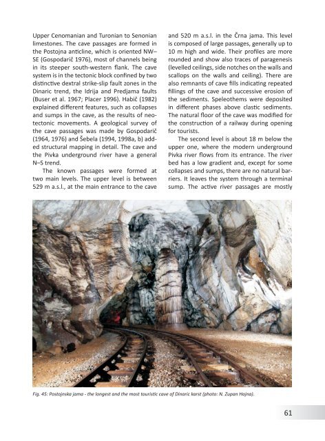
Upper Cenomanian and Turonian to Senonianlimestones. The cave passages are formed in<strong>the</strong> Postojna anticline, which is oriented NW–SE (Gospodarič 1976), most <strong>of</strong> channels beingin its steeper south-western flank. The cavesystem is in <strong>the</strong> tectonic block confined by twodistinctive dextral strike-slip fault zones in <strong>the</strong><strong>Dinaric</strong> trend, <strong>the</strong> Idrija and Predjama faults(Buser et al. 1967; Placer 1996). Habič (1982)explained different features, such as collapsesand sumps in <strong>the</strong> cave, as <strong>the</strong> results <strong>of</strong> neotectonicmovements. A geological survey <strong>of</strong><strong>the</strong> cave passages was made by Gospodarič(1964, 1976) and Šebela (1994, 1998a, b) addedstructural mapping in detail. The cave and<strong>the</strong> Pivka underground river have a generalN–S trend.The known passages were formed attwo main levels. The upper level is between529 m a.s.l., at <strong>the</strong> main entrance to <strong>the</strong> caveand 520 m a.s.l. in <strong>the</strong> Črna jama. This levelis composed <strong>of</strong> large passages, generally up to10 m high and wide. Their pr<strong>of</strong>iles are morerounded and show also traces <strong>of</strong> paragenesis(levelled ceilings, side notches on <strong>the</strong> walls andscallops on <strong>the</strong> walls and ceiling). There arealso remnants <strong>of</strong> cave fills indicating repeatedfillings <strong>of</strong> <strong>the</strong> cave and successive erosion <strong>of</strong><strong>the</strong> sediments. Speleo<strong>the</strong>ms were depositedin different phases above clastic sediments.The natural floor <strong>of</strong> <strong>the</strong> cave was modified for<strong>the</strong> construction <strong>of</strong> a railway during openingfor tourists.The second level is about 18 m below <strong>the</strong>upper one, where <strong>the</strong> modern undergroundPivka river flows <strong>from</strong> its entrance. The riverbed has a low gradient and, except for somecollapses and sumps, <strong>the</strong>re are no natural barriers.It leaves <strong>the</strong> system through a terminalsump. The active river passages are mostlyFig. 45: Postojnska jama - <strong>the</strong> longest and <strong>the</strong> most touristic cave <strong>of</strong> <strong>Dinaric</strong> karst (photo: N. Zupan Hajna).61
smaller than <strong>the</strong> higher ones. The river bed iscomposed mostly <strong>of</strong> gravels derived <strong>from</strong> <strong>the</strong>Eocene flysch. The mean annual discharge <strong>of</strong><strong>the</strong> river is 5.2 m 3 /s. The water level can rise10 m during floods.Cave fill was originally expected not tobe older than Middle Quaternary (i.e. about0.4 Ma). Pleistocene large mammal fauna suchas hippopotamus, cave lion and cave bear,were found here (Rakovec 1954) as well as Paleolithicstone tools <strong>from</strong> <strong>the</strong> last glacial (Brodar1969). Later numerical dating (Th/U andESR) indicated ages older than 0.53 ka. Newpalaeomagnetic data <strong>from</strong> selected sedimentarypr<strong>of</strong>iles within <strong>the</strong> cave system detectednormal polarization in prevalent amount <strong>of</strong>study pr<strong>of</strong>iles. Reverse polarized magnetozones,interpreted mostly as short-livedexcursions <strong>of</strong> magnetic field, were detectedonly in places. Therefore we (Zupan Hajna etal. 2008a, b) interpreted most <strong>of</strong> studied sedimentsas younger than 0.78 Ma, belonging todifferent depositional phases within <strong>the</strong> Brunheschron. Palaeomagnetic properties on twopr<strong>of</strong>iles in <strong>the</strong> caves intersected by artificialtunnel between Postojnska jama and Črnajama with reverse polarized magnetozones,and sediments in Zguba jama, can indicate agedeeply below 0.78 Ma.The cave system shows long evolution governedby <strong>the</strong> function <strong>of</strong> <strong>the</strong> Planinsko poljein <strong>the</strong> relation to <strong>the</strong> evolution <strong>of</strong> resurgencearea in Ljubljana Moor far<strong>the</strong>r on <strong>the</strong> east. Thegeneral stabilization <strong>of</strong> <strong>the</strong> hydrological systemwith low hydraulic head led to evolution<strong>of</strong> caves in epiphreatic and paragenetic conditionsfor a long time-span. Individual cavesegments or passages were fully filled andexhumed several times during <strong>the</strong> cave evolution.The alternation <strong>of</strong> depositional and erosionphases may be connected with changingconditions within <strong>the</strong> cave system, functions<strong>of</strong> <strong>the</strong> resurgence area, collapses, climaticchanges, tectonic movements and <strong>the</strong> intrinsicmechanisms <strong>of</strong> <strong>the</strong> contact karst.Škocjanske jameŠkocjanske jame are 5.8 km long cave. TheReka River enters <strong>the</strong> cave at an altitude <strong>of</strong>317 m; in <strong>the</strong> Martelova dvorana room, it is214 m above sea level (i.e. 103 m lower). TheReka can also sink before it enters <strong>the</strong> cave.Floods usually reach up to 30 m, higher floodsare common too, and <strong>the</strong> largest known floodin <strong>the</strong> 19 th century raised <strong>the</strong> water table levelfor 132 m. Caves are developed in a contactarea <strong>of</strong> Cretaceous thick-bedded rudistic limestoneand Palaeocene thin-bedded dark limestone.The cave is composed <strong>of</strong> phreatic tunnels,and gravitational or paragenetic reshapedgalleries. The proto-channels developedin phreatic conditions along tectonisedbedding-planes. The water flow demanded ahigh degree <strong>of</strong> phreatic rising and falling betweenindividual bedding-planes which, in <strong>the</strong>area <strong>of</strong> <strong>the</strong> chambers Svetinova dvorana andMüllerjeva dvorana, is approximately 175 m.Large quantities <strong>of</strong> water could flow throughall <strong>the</strong>se tunnels, but meanwhile, rubble wastransported through water table caves above<strong>the</strong>m. Such a cave is <strong>the</strong> unro<strong>of</strong>ed cave in Lipovedoline at an altitude <strong>of</strong> around 450 m.A long period followed when <strong>the</strong> piezometricwater table was 340-300 m above sea leveland <strong>the</strong> gradient was in a southwest direction.In it Reka formed new or adopted old passagesby paragenesis and bypassing. These large gallerieswere Mahorčičeva and Mariničeva jama,Tominčeva jama, Schmidlova dvorana in Tihajama. The largest chambers are Martelovadvorana, with a volume <strong>of</strong> 2,100,000 m 3 , andŠumeča jama (870,000 m 3 ). Some <strong>of</strong> big chamberscollapsed forming <strong>the</strong> big collapse dolineslike Velika and Mala dolina.In <strong>the</strong> fur<strong>the</strong>r development <strong>of</strong> Škocjanskejame, potent entrenchment prevailed. Cuttingoccurred in inner parts <strong>of</strong> <strong>the</strong> cave, in Hankejevchannel for about 80 m, much less, about10 m, in <strong>the</strong> eastern, entrance part <strong>of</strong> <strong>the</strong> cave.The first paths in <strong>the</strong> cave area were madein 1823, but <strong>the</strong> construction <strong>of</strong> paths for ex-62
- Page 2 and 3:
Andrej Mihevc, Mitja Prelovšek, Na
- Page 4 and 5:
ContentsGeographical Position and G
- Page 7 and 8:
Fig. 2: Coastal part of Dinaric kar
- Page 9 and 10: ogy started. In 1531 a lawyer from
- Page 11 and 12: include numerous data and general o
- Page 13 and 14: GeologyNadja Zupan HajnaThe Dinaric
- Page 15 and 16: ceous. The final disintegration of
- Page 17 and 18: Fig. 11: Locations of Jelar Breccia
- Page 19 and 20: ClimateMitja PrelovšekThe Dinaric
- Page 21 and 22: 311 mm/a; Zaninović 2008) and incr
- Page 23 and 24: 24Fig. 16: Spatial distribution of
- Page 25 and 26: ocks (such as Eocene flysch, Lower
- Page 27 and 28: absent. Downstreamparts of the cany
- Page 29 and 30: GeomorphologyAndrej MihevcIn folk l
- Page 31 and 32: long. They are smoother especially
- Page 33 and 34: is now depositing. Best known are t
- Page 35 and 36: Structural poljes are dominated by
- Page 37 and 38: Fig. 28: Typical dolines of Dinaric
- Page 39 and 40: the disintegrated collapsed rock at
- Page 41 and 42: on Northern Velebit, where three ca
- Page 43 and 44: Land UseNadja Zupan Hajna, Andrej M
- Page 45 and 46: for ‘bare limestone desert’ -th
- Page 47 and 48: Fig. 38: Grančarevo dam in the upp
- Page 49 and 50: KrasThe Kras is a distinct plateau,
- Page 51 and 52: in this part of the Kras (Mihevc 20
- Page 53 and 54: dolomite barrier along the Idrija w
- Page 55 and 56: of Dolenjska (Gams, 1974; Kranjc, 1
- Page 57 and 58: Fig. 44: Blind valleys of Matarsko
- Page 59: ly several dozen meters deep. Shaft
- Page 63 and 64: tion in the Divaški kras (Mihevc 1
- Page 65 and 66: Use of Karst and its ProtectionThe
- Page 67 and 68: Gams, I., Vrišer, I. (Eds.), 1998:
- Page 69 and 70: lems.- Dela 38, Raziskovalni center