

Assam - Ministry of Environment and Forests
Assam - Ministry of Environment and Forests
Assam - Ministry of Environment and Forests

You also want an ePaper? Increase the reach of your titles
YUMPU automatically turns print PDFs into web optimized ePapers that Google loves.
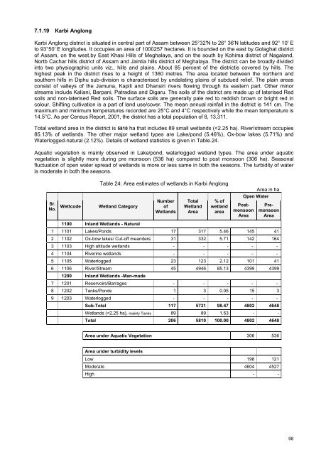
7.1.19 Karbi AnglongKarbi Anglong district is situated in central part <strong>of</strong> <strong>Assam</strong> between 25°32'N to 26° 36'N latitudes <strong>and</strong> 92° 10' Eto 93°50' E longitudes. It occupies an area <strong>of</strong> 1000257 hectares. It is bounded on the east by.Golaghat district<strong>of</strong> <strong>Assam</strong>, on the west.by East Khasi Hills <strong>of</strong> Meghalaya, <strong>and</strong> on the south by Kohima district <strong>of</strong> Nagal<strong>and</strong>,Nortb Cachar hills district <strong>of</strong> <strong>Assam</strong> <strong>and</strong> Jaintia hills district <strong>of</strong> Meghalaya. The district can be broadly dividedinto two physiographic units viz., hills <strong>and</strong> plains. About 85 percent <strong>of</strong> the districtis covered by hills. Thehighest peak in the district rises to a height <strong>of</strong> 1360 metres. The area located between the northern <strong>and</strong>southern hills in Diphu sub-division is characterised by undalating plains <strong>of</strong> subdued relief. The plain areasconsist <strong>of</strong> valleys <strong>of</strong> the Jamuna, Kapili <strong>and</strong> Dhansiri rivers flowing through its eastern part. Other minorstreams include Kaliani, Barpani, Patradisa <strong>and</strong> Digaru. The soils <strong>of</strong> the district are made up <strong>of</strong> laterised Redsoils <strong>and</strong> non-laterised Red soils. The surface soils are generally pale red to reddish brown or bright red incolour. Shifting cultivation is a part <strong>of</strong> l<strong>and</strong> use/cover. The mean annual rainfall in the district is 141 cm. Themaximum <strong>and</strong> minimum temperatures recorded are 25°C <strong>and</strong> 4°C respectively while the mean temperature is14.5°C. As per Census Report, 2001, the district has a total population <strong>of</strong> 8, 13,311.Total wetl<strong>and</strong> area in the district is 5810 ha that includes 89 small wetl<strong>and</strong>s (


