

Assam - Ministry of Environment and Forests
Assam - Ministry of Environment and Forests
Assam - Ministry of Environment and Forests

Create successful ePaper yourself
Turn your PDF publications into a flip-book with our unique Google optimized e-Paper software.
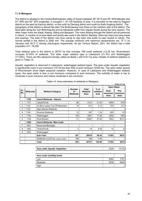
7.1.9 MarigaonThe district is situated in the Central Brahmaputra valley <strong>of</strong> <strong>Assam</strong> between 26 o 00' N <strong>and</strong> 26 o 40'N latitudes <strong>and</strong>91 o 59'E <strong>and</strong> 92 o 35'E longitudes. It occupies 1, 91,100 hectares <strong>of</strong> area. It is bounded on the east by Nagaondistrict,on the west by Kamrup district, on the north by Darrang district <strong>and</strong> south by Karbi Anglong.district. Thetopography <strong>of</strong> the district is almost flat plain.The Brahmaputra river flows on the northern side <strong>of</strong> the district. Theflood plain along the river Brahmaputra <strong>and</strong> its tributaries suffer from regular floods during the rainy season. Theother major rivers are Kapili, Kalang, Killing <strong>and</strong> Barapani. The rivers flowing through the district are all perennialin nature. A number <strong>of</strong> ox-bow lakes <strong>and</strong> ponds also exist in the district. Besides, there are many low lying areas<strong>and</strong> swamps. The soils <strong>of</strong> the district vary from s<strong>and</strong>y to clay loam <strong>and</strong> acidic to near neutral in nature. Thenormal rainfall in the district is 2000 mm. The average minimum <strong>and</strong> maximum temperatures are 8 o C (inJanuary) <strong>and</strong> 34.3 o C (during July/Augus) respectively. As per Census Report, 2001, the district has a totalpopulation <strong>of</strong> 7, 76,256Total wetl<strong>and</strong> area in the district is 28737 ha that includes 158 small wetl<strong>and</strong>s (


