

Assam - Ministry of Environment and Forests
Assam - Ministry of Environment and Forests
Assam - Ministry of Environment and Forests

Create successful ePaper yourself
Turn your PDF publications into a flip-book with our unique Google optimized e-Paper software.
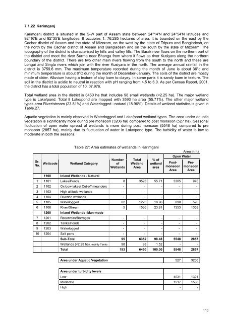
7.1.22 KarimganjKarimganj district is situated in the S-W part <strong>of</strong> <strong>Assam</strong> state between 24°14'N <strong>and</strong> 24°54'N latitudes <strong>and</strong>92°16'E <strong>and</strong> 92°35'E longitudes. It occupies 1, 76,285 hectares <strong>of</strong> area. It is bounded on the east by theCachar district <strong>of</strong> <strong>Assam</strong> <strong>and</strong> the state <strong>of</strong> Mizoram, on the west by the state <strong>of</strong> Tripura <strong>and</strong> Bangladesh, onthe north by the Cachar district <strong>of</strong> <strong>Assam</strong> <strong>and</strong> Bangladesh <strong>and</strong> on the south by the state <strong>of</strong> Mizoram. Thetopography <strong>of</strong> the district is characterised by hills <strong>and</strong> valley fills. The Barak river flows on the northern part <strong>of</strong>the district <strong>and</strong> meet the river Surma near Bhanga from where it flows as river Kusiyara along the northernboundary <strong>of</strong> the district. There are two other main rivers flowing from the south to the north <strong>and</strong> these areLongai <strong>and</strong> Singla rivers which join with the river Kusiyara in the north. The average annual rainfall in thedistrict is 3759.6 mm. The maximum temperature recorded during the month <strong>of</strong> June is about 36°c <strong>and</strong>minimum temperature is about 8°C during the month <strong>of</strong> December-January. The soils <strong>of</strong> the district are mostlymade <strong>of</strong> older. Alluvium having a texture <strong>of</strong> clay loam to clayey. In some parts it is s<strong>and</strong>y loam in texture. Thesoil in the district is acidic to neutral in reaction with pH ranging from 4.5 to 6.0. As per Census Report, 2001,the district has a total population <strong>of</strong> 10, 07,976.Total wetl<strong>and</strong> area in the district is 6450 ha that includes 98 small wetl<strong>and</strong>s (


