

Assam - Ministry of Environment and Forests
Assam - Ministry of Environment and Forests
Assam - Ministry of Environment and Forests

Create successful ePaper yourself
Turn your PDF publications into a flip-book with our unique Google optimized e-Paper software.
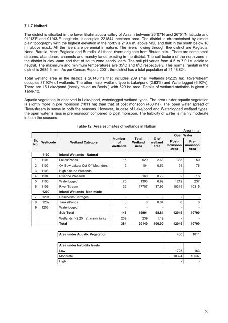
7.1.7 NalbariThe district is situated in the lower Brahmaputra valley <strong>of</strong> <strong>Assam</strong> between 26 o 07’N <strong>and</strong> 26°51’N latitude <strong>and</strong>91°13’E <strong>and</strong> 91°43’E longitude. It occupies 221844 hectares area. The district is characterised by almostplain topography with the highest elevation in the north is 219.6 m. above MSL <strong>and</strong> that in the south below 18m. above m.s.l.. All the rivers are perennial in nature. The rivers flowing through the district are Pagladia,Nona, Baralia, Mara Pagladia <strong>and</strong> Buradia. All these rivers originate from Bhutan hills. There are some smallstreams, ab<strong>and</strong>oned channels <strong>and</strong> marshy l<strong>and</strong>s existing in the district. The soil texture <strong>of</strong> the north zone inthe district is clay loam <strong>and</strong> that <strong>of</strong> south zone s<strong>and</strong>y loam. The soil pH varies from 4.5 to 7.0 i.e. acidic toneutral. The maximum <strong>and</strong> minimum temperatures are 35 o C <strong>and</strong> 6 o C respectively. The normal rainfall in thedistrict is 2685.5 mm. As per Census Report, 2001, the district has a total population <strong>of</strong> 11,48,824.Total wetl<strong>and</strong> area in the district is 20140 ha that includes 239 small wetl<strong>and</strong>s (


