

Assam - Ministry of Environment and Forests
Assam - Ministry of Environment and Forests
Assam - Ministry of Environment and Forests

Create successful ePaper yourself
Turn your PDF publications into a flip-book with our unique Google optimized e-Paper software.
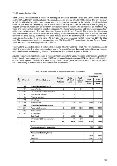
7.1.20 North Cachar HillslNorth Cachar Hills is situated in the south central part .<strong>of</strong> <strong>Assam</strong> between 24°58' <strong>and</strong> 25°47. North latitudes<strong>and</strong> 92°32' <strong>and</strong> 93°28" East longitudes. The district occupies an area <strong>of</strong> 4,89,793 hectares. The only big townis Haflong which is the district head quarter also It is bounded on the east by the Jaintia. hills <strong>of</strong> Meghalayastate, on the west by Tamenglong <strong>and</strong> Kohima districts <strong>of</strong> Nagal<strong>and</strong>, on the north by Karbi Anglong <strong>and</strong>Nagaon districts <strong>of</strong> <strong>Assam</strong> <strong>and</strong> on the south by Cachar district <strong>of</strong> <strong>Assam</strong>. The district consists mainly <strong>of</strong> hillytracts <strong>and</strong> valleys with a negligible extent <strong>of</strong> plain area. The topography is rugged with elevations varying from600 metres to 900 metres. The main rivers are Diyang, Kopili, Jiri <strong>and</strong> Dhansiri. The soils <strong>of</strong> the district varyfrom non-laterised red soil to laterised red soil ranging from s<strong>and</strong>y loam to clayey loam in texture. The nonlaterisedred soils occupy a relatively less area along a strip in the southern part <strong>of</strong> the district. The soi1 isacidic in reaction with pH varying from 4.10 to 6.20. The average annual rainfall varies from 2200 to 2300mm. The maximum <strong>and</strong> minimum temperatures are 25.8°C <strong>and</strong> 5.3°C respectively. As per Census Report,2001, the district has a total population <strong>of</strong> 1, 88,079.Total wetl<strong>and</strong> area in the district is 6619 ha that includes 44 small wetl<strong>and</strong>s (


