

Assam - Ministry of Environment and Forests
Assam - Ministry of Environment and Forests
Assam - Ministry of Environment and Forests

Create successful ePaper yourself
Turn your PDF publications into a flip-book with our unique Google optimized e-Paper software.
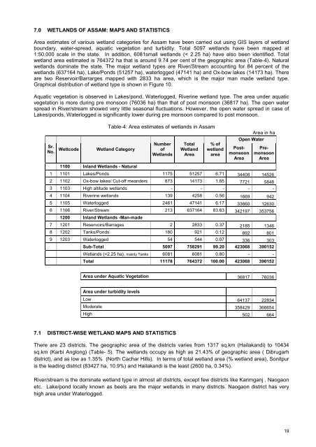
7.0 WETLANDS OF ASSAM: MAPS AND STATISTICSArea estimates <strong>of</strong> various wetl<strong>and</strong> categories for <strong>Assam</strong> have been carried out using GIS layers <strong>of</strong> wetl<strong>and</strong>boundary, water-spread, aquatic vegetation <strong>and</strong> turbidity. Total 5097 wetl<strong>and</strong>s have been mapped at1:50,000 scale in the state. In addition, 6081small wetl<strong>and</strong>s (< 2.25 ha) have also been identified. Totalwetl<strong>and</strong> area estimated is 764372 ha that is around 9.74 per cent <strong>of</strong> the geographic area (Table-4). Naturalwetl<strong>and</strong>s dominate the state. The major wetl<strong>and</strong> types are River/Stream accounting for 84 percent <strong>of</strong> thewetl<strong>and</strong>s (637164 ha), Lake/Ponds (51257 ha), waterlogged (47141 ha) <strong>and</strong> Ox-bow lakes (14173 ha). Thereare two Reservoir/Barrarges mapped with 2833 ha area, which is the major man made wetl<strong>and</strong> type.Graphical distribution <strong>of</strong> wetl<strong>and</strong> type is shown in Figure 10.Aquatic vegetation is observed in Lakes/pond, Waterlogged, Riverine wetl<strong>and</strong> type. The area under aquaticvegetation is more during pre monsoon (76036 ha) than that <strong>of</strong> post monsoon (36817 ha). The open waterspread in River/stream showed very little seasonal fluctuations. However, the open water spread in case <strong>of</strong>Lakes/ponds, Waterlogged is significantly lower during pre monsoon compared to post monsoon.Sr.No.WettcodeTable-4: Area estimates <strong>of</strong> wetl<strong>and</strong>s in <strong>Assam</strong>Wetl<strong>and</strong> CategoryNumber<strong>of</strong>Wetl<strong>and</strong>sTotalWetl<strong>and</strong>Area% <strong>of</strong>wetl<strong>and</strong>areaArea in haOpen WaterPostmonsoonAreaPremonsoonArea1100 Inl<strong>and</strong> Wetl<strong>and</strong>s - Natural1 1101 Lakes/Ponds 1175 51257 6.71 34408 145262 1102 Ox-bow lakes/ Cut-<strong>of</strong>f me<strong>and</strong>ers 873 14173 1.85 7721 58483 1103 High altitude wetl<strong>and</strong>s - - - - -4 1104 Riverine wetl<strong>and</strong>s 139 4258 0.56 1669 9425 1105 Waterlogged 2461 47141 6.17 33660 126306 1106 River/Stream 213 637164 83.63 342197 3537561200 Inl<strong>and</strong> Wetl<strong>and</strong>s -Man-made7 1201 Reservoirs/Barrages 2 2833 0.37 2185 13468 1202 Tanks/Ponds 180 921 0.12 892 8019 1203 Waterlogged 54 544 0.07 336 303Sub-Total 5097 758291 99.20 423068 390152Wetl<strong>and</strong>s (


