

Assam - Ministry of Environment and Forests
Assam - Ministry of Environment and Forests
Assam - Ministry of Environment and Forests

You also want an ePaper? Increase the reach of your titles
YUMPU automatically turns print PDFs into web optimized ePapers that Google loves.
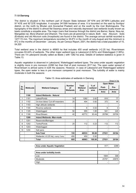
7.1.8 DarrangThe district is situated in the northern part <strong>of</strong> <strong>Assam</strong> State between 26°10'N <strong>and</strong> 26°58'N Latitudes <strong>and</strong>91°43'E <strong>and</strong> 92°22'E longitudes. It occupies 341399 hectares <strong>of</strong> area. It is bounded on the east by Sonitpurdistrict, on the north by Bhutan <strong>and</strong> Arunachal Pradesh <strong>and</strong> on the south by the river Brahmaputra. Thetopography <strong>of</strong> the district is almost flat Swampy areas <strong>and</strong> naturally depressed vast wetl<strong>and</strong>s locally known asbeels constitute a sizeable area. The major rivers that traverse through the district are Barnoi, Nanai, Noa-nai,Mangaldai nai, Mora Dhansiri <strong>and</strong> Dhansiri. The rivers are all perennial in nature. Both new Alluvium Soils(Entisols) <strong>and</strong> old Alluvium soils (Inceptisols) are found in the district. The average annual rainfall recorded is1477.72 mm. The maximum temperature recorded is 35.6 o C in the month <strong>of</strong> July-August <strong>and</strong> the minimum is6 o C in the months <strong>of</strong> December - January. As per Census Report, 2001, the district has a total population <strong>of</strong> 15,04,320Total wetl<strong>and</strong> area in the district is 48983 ha that includes 450 small wetl<strong>and</strong>s (


