1202 Tanks/Ponds: A term used in Ceylon <strong>and</strong> the drier parts <strong>of</strong> Peninsular India for an artificial pond, poolor lake formed by building a mud wall across the valley <strong>of</strong> a small stream to retain the monsoon(Margarate et al, 1974). Ponds Generally, suggest a small, quiet body <strong>of</strong> st<strong>and</strong>ing water, usuallyshallow enough to permit the growth <strong>of</strong> rooted plants from one shore to another (Reid et al, 1976).Tanks appear in light blue colour showing bottom reflectance.In this category Industrial ponds/mining pools mainly comprising Ab<strong>and</strong>oned Quarries are alsoincluded (Quarry is defined as "An open or surface working or excavation for the extraction <strong>of</strong> stone,ore, coal, gravel or minerals." In such pits water accumulate (McGraw Hill Encyclopaedia <strong>of</strong><strong>Environment</strong>al Sciences, 1974), Ash pond/Cooling pond (The water body created for dischargingeffluents in industry, especially in thermal power plants (Encyclopaedic Directory <strong>of</strong> <strong>Environment</strong>,1988) <strong>and</strong> Cooling pond: An artificial lake used for the natural cooling <strong>of</strong> condenser-cooling waterserving a conventional power station (Encyclopaedic Directory <strong>of</strong> <strong>Environment</strong>, 1988). These pondscan be <strong>of</strong> any shape <strong>and</strong> size. Texture is rough <strong>and</strong> tonal appearance light (quarry) to blue shade(cooling pond).1203 Waterlogged : Man-made activities like canals cause waterlogging in adjacent areas due to seepageespecially when canals are unlined. Such areas can be identified on the images along canal network.Tonal appearance is in various hues <strong>of</strong> blue. Sometimes, such waterlogged areas dry up <strong>and</strong> leavewhite scars on the l<strong>and</strong>. Texture is smooth.1204 Salt pans: Inl<strong>and</strong> salt pans in India occur in Rajasthan (Sambhar lake). These are shallow rectangularman-made depressions in which saline water is accumulated for drying in the sun for making salt.2000 Coastal Wetl<strong>and</strong>s2100 Natural2101 Lagoons/Backwaters: Such coastal bodies <strong>of</strong> water, partly separated from the sea by barrierbeaches or bass <strong>of</strong> marine origin, are more properly termed lagoons. As a rule, lagoons are elongate<strong>and</strong> lie parallel to the shoreline. They are usually characteristic <strong>of</strong>, but not restricted to, shores <strong>of</strong>emergence. Lagoons are generally shallower <strong>and</strong> more saline than typical estuaries (Reid et al, 1976).Backwater: A creek, arm <strong>of</strong> the sea or series <strong>of</strong> connected lagoons, usually parallel to the coast,separated from the sea by a narrow strip <strong>of</strong> l<strong>and</strong> but communicating with it through barred outlets(Margarate et al, 1974).2102 Creek: A notable physiographic feature <strong>of</strong> salt marshes, especially low marshes. These creeksdevelop as do rivers "with minor irregularities sooner or later causing the water to be deflected intodefinite channels" (Mitsch <strong>and</strong> Gosselink, 1986). Creeks will be delineated, however, their area willnot be estimated.2103 S<strong>and</strong>/Beach: Beach is an unvegetated part <strong>of</strong> the shoreline formed <strong>of</strong> loose material, usually s<strong>and</strong>that extends from the upper berm (a ridge or ridges on the backshore <strong>of</strong> the beach, formed by thedeposit <strong>of</strong> material by wave action, that marks the upper limit <strong>of</strong> ordinary high tides <strong>and</strong> wave wash tolow water mark(Clark,1977).Beach comprising rocky material is called rocky beach.2104 Intertidal mudflats: Most unvegetated areas that are alternately exposed <strong>and</strong> inundated by thefalling <strong>and</strong> rising <strong>of</strong> the tide. They may be mudflats or s<strong>and</strong> flats depending on the coarseness <strong>of</strong> thematerial <strong>of</strong> which they are made (Clark, 1977).2105 Salt Marsh: Natural or semi-natural halophytic grassl<strong>and</strong> <strong>and</strong> dwarf brushwood on the alluvialsediments bordering saline water bodies whose water level fluctuates either tidally or non- tidally(Mitsch <strong>and</strong> Gosselink, 1986). Salt marshes look in grey blue shade when wet.2106 Mangroves: The mangrove swamp is an association <strong>of</strong> halophytic trees, shrubs, <strong>and</strong> other plantsgrowing in brackish to saline tidal waters <strong>of</strong> tropical <strong>and</strong> sub-tropical coastlines (Mitsch <strong>and</strong> Gosselink,1986). On the satellite images mangroves occur in red colour if in contiguous patch. When mangroveassociations are scattered or are degraded then instead <strong>of</strong> red colour, brick red colour may be seen.2107 Coral reefs: Consolidated living colonies <strong>of</strong> microscopic organisms found in warm tropical waters. Theterm coral reef, or organic reef is applied to the rock- like reefs built-up <strong>of</strong> living things, principallycorals. They consist <strong>of</strong> accumulations <strong>of</strong> calcareous deposits <strong>of</strong> corals <strong>and</strong> corraline algae with theintervening space connected with s<strong>and</strong>, which consists largely <strong>of</strong> shells <strong>of</strong> foraminefera. Present reefsare living associations growing on this accumulation <strong>of</strong> past (Clark, 1977). Reefs appear in light blueshade.2200 Man-made2201 Salt pans: An undrained usually small <strong>and</strong> shallow rectangular, man-made depression or hollow inwhich saline water accumulates <strong>and</strong> evaporates leaving a salt deposit (Margarate et al, 1974). Saltpans are square or rectangular in shape. When water is there appearance is blue while salt is formedtone is white.2202 Aquaculture ponds: Aquaculture is defined as "The breeding <strong>and</strong> rearing <strong>of</strong> fresh-water or marinefish in captivity. Fish farming or ranching". The water bodies used for the above are called aquacultureponds (Encyclopaedic Directory <strong>of</strong> <strong>Environment</strong>, 1988). Aquaculture ponds are geometrical in shapeusually square or rectangular. Tone is blue.172
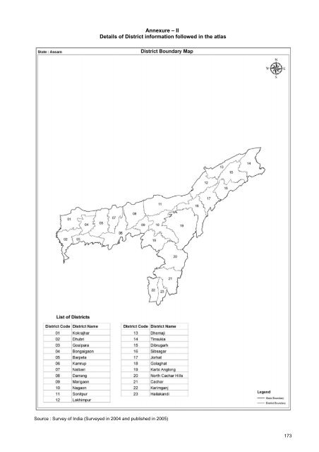
Annexure – IIDetails <strong>of</strong> District information followed in the atlasSource : Survey <strong>of</strong> India (Surveyed in 2004 <strong>and</strong> published in 2005)173
- Page 1 and 2:
NATIONAL WETLAND ATLAS:ASSAMSponsor
- Page 3 and 4:
AtlasSAC/RESA/AFEG/NWIA/ATLAS/18/20
- Page 7:
FOREWORDWetlands defined as areas o
- Page 11:
PROJECT TEAMProject Director: Dr. (
- Page 15 and 16:
1.0 INTRODUCTIONIt is increasingly
- Page 17 and 18:
RedGreenNIR RED GREENNIRSWIRFigure
- Page 19 and 20:
2.0 NATIONAL WETLAND INVENTORY AND
- Page 21 and 22:
3.0 STUDY AREAAssam is one of the 7
- Page 23 and 24:
4.0 DATA USED4.1 Remote sensing dat
- Page 25 and 26:
October 27, 2006March 20, 2007Figur
- Page 27 and 28:
IRS P6 LISS III(pre- and post-monso
- Page 29 and 30:
Map composition for atlas has been
- Page 31:
MAPS AND STATISTICS17
- Page 34 and 35:
District-wise wetland area estimate
- Page 40:
7.1.1 KokrajharKokrajhar district i
- Page 52:
7.1.4 BongaigaonThe district is sit
- Page 60:
7.1.6 KamrupThe district is situate
- Page 68:
7.1.8 DarrangThe district is situat
- Page 76:
7.1.10 NagaonThe district is situat
- Page 84:
7.1.12 LakhimpurThe district is sit
- Page 92:
7.1.14 TinsukiaThe district is situ
- Page 100:
7.1.16 SibsagarThe district is situ
- Page 108:
7.1.18 GolaghatGolaghat district is
- Page 114 and 115:
100
- Page 116 and 117:
7.1.20 North Cachar HillslNorth Cac
- Page 118 and 119:
104
- Page 120 and 121:
7.1.21 CacharCachar district is sit
- Page 122 and 123:
108
- Page 124 and 125:
7.1.22 KarimganjKarimganj district
- Page 126 and 127:
112
- Page 128 and 129:
7.1.23 HailakandiHailakandi distric
- Page 130 and 131:
116
- Page 132 and 133:
118
- Page 134 and 135:
120
- Page 136 and 137: Post-monsoon dataOx-bow lakesRiverW
- Page 138 and 139: Sr. No.5.DescriptionWetland Type: R
- Page 140 and 141: Plate 3: Field observation on the s
- Page 142 and 143: 128
- Page 144 and 145: 9.1 Deepor BeelNameLocationAreaAlti
- Page 146 and 147: 132
- Page 148 and 149: 9.2 Dhir BeelNameLocationAreaWetlan
- Page 150 and 151: 136
- Page 152 and 153: 9.3 Sareswar BeelNameLocationAreaWe
- Page 154 and 155: 140
- Page 156 and 157: 9.4 Sone LakeNameLocationAreaAltitu
- Page 158 and 159: 144
- Page 160 and 161: 9.5 Tamaranga BeelNameLocationAreaW
- Page 162 and 163: 148
- Page 164 and 165: 9.6 Sonai Beel (Nandini/Mer/Sonai/R
- Page 166 and 167: 152
- Page 168 and 169: 154
- Page 170 and 171: 156
- Page 172 and 173: 158
- Page 174 and 175: 160
- Page 176 and 177: 162
- Page 178 and 179: 164
- Page 180 and 181: 166
- Page 182 and 183: 168
- Page 184 and 185: 170
- Page 188 and 189: 174
- Page 190: Space Applications centreIndian Spa