- Page 5 and 6:
2010 Multi-jurisdictional Hazard Mi
- Page 7 and 8:
Table A-2 Indicators of Economic Gr
- Page 9 and 10:
infrastructure improvements such as
- Page 11 and 12:
The Comprehensive Land Use Plan Upd
- Page 13 and 14:
Growth and DevelopmentGoal: Manage
- Page 15 and 16:
Land UseLand use development goals
- Page 17 and 18:
Objective 6:Encourage well-planned
- Page 19 and 20:
Implementation Strategies:• Work
- Page 21 and 22:
Community Services and FacilitiesAl
- Page 23 and 24:
Natural EnvironmentThe northern por
- Page 25 and 26:
• Maintain open space, recreation
- Page 27 and 28:
• Continue to provide assistance
- Page 29 and 30:
Parks and Recreational FacilitiesAc
- Page 31 and 32:
program, to help solve the problem
- Page 33 and 34:
Objective 3:Continue to educate res
- Page 35 and 36:
Implementation Strategies:• Prepa
- Page 37 and 38:
Rural CommercialLimited commercial
- Page 39 and 40:
Section Four: Plan AmendmentsInitia
- Page 41 and 42:
Appendix A: Inventory and AnalysisH
- Page 43 and 44:
problems and issues, preparation of
- Page 45 and 46:
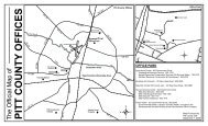
Insert Map A-1 Pitt County Planning
- Page 47 and 48:
General Location and DescriptionPit
- Page 49 and 50:
Municipalities within Pitt CountyTh
- Page 51 and 52:
SimpsonThe Village of Simpson was i
- Page 53 and 54:
Pitt County EconomyThe Pitt County/
- Page 55 and 56:
Table A-3Workforce by Industry in P
- Page 57 and 58:
Table A-5Major Manufacturers in Pit
- Page 59 and 60:
Agricultural EconomyAgriculture in
- Page 61 and 62:
CropTable A-10Pitt County Crops - 2
- Page 63 and 64:
EducationA local education system c
- Page 65 and 66:
Brody School of Medicine and Pitt C
- Page 67 and 68:
Figure BMinority Populations in Pit
- Page 69 and 70:
IncomeBased on the 2009 American Co
- Page 71 and 72:
HousingHome prices in Pitt County s
- Page 73 and 74:
Pitt County DemographicsPitt County
- Page 75 and 76:
Table A-20Growth by Township - 1970
- Page 77 and 78: Insert Map A-3 Growth by Townships(
- Page 79 and 80: Table A-23Comparison of Population
- Page 81 and 82: Median AgeMedian age has continued
- Page 83 and 84: 2009 American Community SurveyThe A
- Page 85 and 86: Table A-29Housing Occupancy by Hous
- Page 87 and 88: Planning Policies2002 Comprehensive
- Page 89 and 90: motorists, maintain roadside views
- Page 91 and 92: The County enforces the ordinance w
- Page 93 and 94: Existing Land Use (Map A-4)As of Ju
- Page 95 and 96: Insert Map A-4 Existing Land Use(No
- Page 97 and 98: NC Transportation Improvement Progr
- Page 99 and 100: 3. NC 43/Ivy RoadImprove safety and
- Page 101 and 102: Bus and Mass Transit ServicesThe Gr
- Page 103 and 104: Parks and RecreationThe availabilit
- Page 105 and 106: Pitt County Greenway PlanThe Pitt C
- Page 107 and 108: TrailTable A-36Pitt County Walking
- Page 109 and 110: held a workshop with ground water u
- Page 111 and 112: Figure FCentral Coastal Plain Capac
- Page 113 and 114: Table A-37Water Treatment Systems &
- Page 115 and 116: Insert Map A-5 Public Infrastructur
- Page 117 and 118: “There has been a tendency in the
- Page 119 and 120: Flood HazardsA combination of river
- Page 121 and 122: Water Supply Watershed Protection (
- Page 123 and 124: Stormwater RegulationsPitt County,
- Page 125 and 126: discharges. Illegal discharges may
- Page 127: Riparian buffers provide a number o
- Page 131 and 132: Soil Suitability (Map A-8)Pitt Coun
- Page 133 and 134: Insert Map A-8 Soil Suitability(Not
- Page 135 and 136: 2. What are some of your ideas abou
- Page 137: • Areas north of US Highway 264 a