2030 Comprehensive Land Use Plan - Pitt County Government
2030 Comprehensive Land Use Plan - Pitt County Government
2030 Comprehensive Land Use Plan - Pitt County Government
- No tags were found...

You also want an ePaper? Increase the reach of your titles
YUMPU automatically turns print PDFs into web optimized ePapers that Google loves.
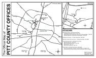
BethelThe Town of Bethel, a small town with approximately one (1) square mile of land area, wasincorporated in 1873. Bethel is located in the extreme northern portion of the <strong>County</strong>immediately adjacent to the boundary with Martin <strong>County</strong>. During the past decade thepopulation of Bethel decreased from 1,681 persons (2000 U.S. Census) to 1,577 persons(2010 U.S. Census) – a decrease of -6.2%. A mayor and five commissioners govern thetown.FalklandThe Town of Falkland, located in the northwest portion of the <strong>County</strong>, was incorporated in1893. Falkland incorporates 0.23 square miles of land area and in the 2010 U.S. Census hada population of 96 persons – a decrease of -14.3% from the 2000 U.S. Census population of112 persons. A mayor and three commissioners govern the town.FarmvilleThe Town of Farmville, incorporated in 1872, covers a land area of 3.06 square miles. Thetown is located just south of US 264 in the western portion of the <strong>County</strong> near theboundary with Greene <strong>County</strong>. The 2010 U.S. Census population for Farmville was 4,654persons – an increase of 8.2% over the 2000 U.S. Census of 4,302 persons. A mayor andfive commissioners govern the town.FountainThe Town of Fountain, located near the intersection of NC 222 and NC 258 in the farwestern portion of the <strong>County</strong> was incorporated in 1906. The town incorporates 0.92square miles of land area and had a 2010 U.S. Census population of 427 persons – adecrease of -19.9% over the 2000 U.S. Census figure of 533 persons.GriftonThe Town of Grifton was incorporated in 1883 and is located on the extreme southernboundary with Lenoir <strong>County</strong>. Grifton is the only municipality not wholly within <strong>Pitt</strong><strong>County</strong>. In the 2010 U.S. Census, Grifton had a population of 2,617 persons – an increase of26.2% over the 2000 U.S. Census figure of 2,073 persons. In 2010, the majority of thetown’s residents – 2,431 or 93% - lived in <strong>Pitt</strong> <strong>County</strong> and only 186 persons – 7% - lived inLenoir <strong>County</strong>. Grifton incorporates 1.97 square miles of land area and is governed by amayor and five commissioners.GrimeslandThe Town of Grimesland is located in the far eastern portion of the <strong>County</strong> on NC 33.Grimesland covers 0.68 square miles of land area and was incorporated in 1893. Thepopulation of Grimesland in the 2010 U.S. Census – 441 persons – represented a 0.2%increase over the 2000 U.S. Census figure of 440 persons. A mayor and four aldermengovern the town.<strong>2030</strong> <strong>Comprehensive</strong> <strong>Land</strong> <strong>Use</strong> <strong>Plan</strong> Appendix A: Inventory and Analysis<strong>Pitt</strong> <strong>County</strong>, North Carolina A-10