2030 Comprehensive Land Use Plan - Pitt County Government
2030 Comprehensive Land Use Plan - Pitt County Government
2030 Comprehensive Land Use Plan - Pitt County Government
- No tags were found...

Create successful ePaper yourself
Turn your PDF publications into a flip-book with our unique Google optimized e-Paper software.
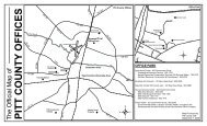
General Location and Description<strong>Pitt</strong> <strong>County</strong> is located in the central Coastal Plain section of eastern North Carolina. The<strong>County</strong> covers 656 square miles of total area with three (3) square miles covered by water.<strong>County</strong> boundaries are defined by the seven surrounding counties - Beaufort <strong>County</strong> to theeast, Martin <strong>County</strong> to the northeast, Edgecombe <strong>County</strong> on the northwest, Wilson andGreene Counties on the west, Lenoir <strong>County</strong> on the southwest, and Craven <strong>County</strong> to thesoutheast. The City of Greenville, located approximately in the geographic center of the<strong>County</strong>, is the county seat.Roughly diamond-shaped, <strong>Pitt</strong> <strong>County</strong> is approximately thirty-four (34) miles long north tosouth and thirty (30) miles wide at the widest point. Topography is gently rolling with landelevations ranging from twenty (20) feet above sea level in the southeastern portion of the<strong>County</strong> to two hundred ten (210) feet above sea level in the extreme western portion of the<strong>County</strong>. Slopes are typically less than 4% except for the steeper southern banks of the TarRiver and its tributaries.The northern portion of the <strong>County</strong> (58.7% of the land area) is within the Tar River Basin, whichdrains into Pamlico Sound just east of the <strong>County</strong> line. The southern and extreme westernportions of the <strong>County</strong> (41.3% of the land area) are drained by Swift Creek and ContentneaCreek, which flow into the Neuse River at the southeastern tip of the <strong>County</strong>.Global TransPark Development Zone<strong>Pitt</strong> <strong>County</strong> is located in a thirteen-county region organized as the Global TransPark (GTP)Development Zone by an act of the NC General Assembly in the early 1990s. GTPheadquarters is located thirty minutes south of Greenville at the Kinston Regional Jetportin Lenoir <strong>County</strong> north of the City of Kinston. The GTP is a combination air cargo airportand transportation, manufacturing, and distribution complex.The purpose of the GTP is to provide industries with direct access to multi-modaltransportation alternatives to enable industries to maximize efficient and reliabletransportation. The GTP also has an on-site education and training facility to providetraining opportunities. The GTP is designated as Foreign Trade Zone 214 where companiescan export and import products without many of the usual customs restrictions and tariffs.Although the initial projections for fast growth of employment opportunities associatedwith the GTP have yet to materialize, the GTP concept still holds promise as a long-rangeinfluence on the economy of the region.<strong>2030</strong> <strong>Comprehensive</strong> <strong>Land</strong> <strong>Use</strong> <strong>Plan</strong> Appendix A: Inventory and Analysis<strong>Pitt</strong> <strong>County</strong>, North Carolina A-7