2030 Comprehensive Land Use Plan - Pitt County Government
2030 Comprehensive Land Use Plan - Pitt County Government
2030 Comprehensive Land Use Plan - Pitt County Government
- No tags were found...

Create successful ePaper yourself
Turn your PDF publications into a flip-book with our unique Google optimized e-Paper software.
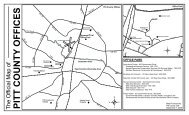
Rural CommercialLimited commercial service land uses that are appropriate in a prevailing rural/agriculturalcontext. Appropriate land uses include a mix of residential, public/institutional, and limitedcommercial and service uses. <strong>Land</strong> uses within this category would be expected to developwithout public sewer, i.e., with private septic tank systems. This category is designated atprominent intersections located throughout the <strong>County</strong> where small, community-oriented,commercial land uses are already present, and/or where additional non-residential serviceswould serve surrounding residential populations. Designated at the followingintersections: Calico, Gardnerville, Pactolus, Venters, Ballards Crossroads, Rountree, andOld Creek Road/Whichard Road.Commercial Crossroad CommunityLimited commercial land uses that are appropriate to crossroads development.Appropriate land uses include a mix of residential, public/institutional, and commercialuses. Residential uses can be located near non-residential uses with appropriate buffers.<strong>Land</strong> uses within this category could develop with public sewer or private septic tanksystems. This category is designated at prominent crossroads locations throughout the<strong>County</strong> where existing commercial development provides goods and services to a largersurrounding population. Designated at the following crossroad communities: Bell Arthur,Belvoir, Black Jack, Chicod, Eastern Pines, Hollywood, Stokes, Worthington, and theintersection of US 264 and Old Washington Road.CommercialCommercial uses, office and public/institutional uses, light industrial, limited residentialuses. Moderate to large scale commercial uses should transition to office/institutional usesor higher density residential uses that would buffer surrounding lower density residentialareas. Designated at the following locations: US 264 East near intersection with MartinLuther King Jr. Highway, NC 30/US 264 East intersection near Pactolus, Mozingo Road/US264 West interchange, NC 33/Martin Luther King Jr. /US 264 West interchange, NC 43South Corridor near Bells Fork, US 13 corridor near Frog Level.Heavy Commercial/IndustrialHeavy commercial and industrial uses, wholesale, office and public/institutional uses.Surrounding residential uses should be spatially separated from high intensity commercialand industrial uses where noise, odors, or other negative effects could be expected.Designated at the US 264 East/Sheppard Mill Road intersection and near NC 33/BarrusConstruction Road intersection.<strong>2030</strong> <strong>Comprehensive</strong> <strong>Land</strong> <strong>Use</strong> <strong>Plan</strong> Future <strong>Land</strong> <strong>Use</strong> Map<strong>Pitt</strong> <strong>County</strong>, North Carolina 3-2