2030 Comprehensive Land Use Plan - Pitt County Government
2030 Comprehensive Land Use Plan - Pitt County Government
2030 Comprehensive Land Use Plan - Pitt County Government
- No tags were found...

Create successful ePaper yourself
Turn your PDF publications into a flip-book with our unique Google optimized e-Paper software.
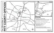
SimpsonThe Village of Simpson was incorporated in 1975 with a land area of 0.37 square miles. Thepopulation of Simpson in the 2010 U.S. Census was 416 persons – a decrease of -10.3% overthe 2000 U.S. Census population of 464 persons. A mayor and two council membersgovern the village.WintervilleThe Town of Winterville, covering just over 4.50 square miles of land area, wasincorporated in 1897. Winterville is located just south of the City of Greenville along NC 11.The Town of Winterville had the fastest population growth between 2000 and 2010 with a2010 U.S. Census population of 9,269 persons – an increase of 93.5% over the 2000 U.S.Census figure of 4,791 persons. A mayor and five aldermen govern Winterville.Crossroad Communities (Map A-1)Well-known crossroad communities within <strong>Pitt</strong> <strong>County</strong> include Black Jack, Chicod, Gardnervilleand Shelmerdine in southeastern <strong>Pitt</strong> <strong>County</strong>, Bell Arthur (on US 264 between Greenville andFarmville), Belvoir (intersection of NC 33 and NC 222), Stokes (intersection of NC 30 and NC903 northeast of Greenville), and Pactolus (US 264 east of Greenville).<strong>2030</strong> <strong>Comprehensive</strong> <strong>Land</strong> <strong>Use</strong> <strong>Plan</strong> Appendix A: Inventory and Analysis<strong>Pitt</strong> <strong>County</strong>, North Carolina A-11