A Management Guide for Invasive Plants in Southern Forests James ...
A Management Guide for Invasive Plants in Southern Forests James ...
A Management Guide for Invasive Plants in Southern Forests James ...
- No tags were found...

You also want an ePaper? Increase the reach of your titles
YUMPU automatically turns print PDFs into web optimized ePapers that Google loves.
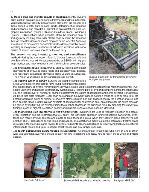
123. Make a map and monitor results of locations. Identify <strong>in</strong>vasiveplant location sites at risk, and denote treatments and their outcomes.You must positively identify those <strong>in</strong>vasive plants that are present andthose poised to enter from adjacent lands, determ<strong>in</strong>e their locationsand abundance, and record this <strong>in</strong><strong>for</strong>mation on a sketch map or GeographicIn<strong>for</strong>mation System (GIS) map. Ga<strong>in</strong> their Global Position<strong>in</strong>gSystem (GPS) locations when possible. Make the locations easy tof<strong>in</strong>d aga<strong>in</strong> by mark<strong>in</strong>g them with plastic flags. Monitor the locationsthrough repeated visits and record progress or the lack of it. Agenciesshould map as many acres as possible with the dollars available be<strong>for</strong>e<strong>in</strong>vest<strong>in</strong>g <strong>in</strong> unorganized treatments of extensive <strong>in</strong>vasions, while newentries of severe <strong>in</strong>vasives should be tackled early.The search, survey, Inventory, monitor, and surveillancemethod—Us<strong>in</strong>g the four-option Search, Survey, Inventory, Monitor,and Surveillance method, hereafter referred to as SSIMS, will help youmap, monitor, and track treatments with their results at several scales.• The first SSIMS option is search<strong>in</strong>g. Start by look<strong>in</strong>g at the mostlikely po<strong>in</strong>ts of entry, like along roads and especially near bridges,and record any occurrence of <strong>in</strong>vasive plants you f<strong>in</strong>d <strong>in</strong> such areas.Then widen your search as time and resources permit.<strong>Invasive</strong> plants can be transported on wildlifefood-plot equipment.• The second option is survey. Surveys are used to sample largeareas where search procedures have found numerous <strong>in</strong>festationsthat are too many to <strong>in</strong>ventory <strong>in</strong>dividually. Surveys are also used to exam<strong>in</strong>e large tracks when the amount of <strong>in</strong>vasionis unknown and access is difficult. By systematically locat<strong>in</strong>g plots or by band sampl<strong>in</strong>g across the landscape,you can record cover or number of clumps to determ<strong>in</strong>e the extent of occupation and acres covered. For example,21- by 21-foot plots represent 0.001 of an acre and can be evenly spaced across a stand of trees or area. Total thepercent estimated cover or number of <strong>in</strong>vasive stems counted per plot, divide these by the number of plots, andthen multiple times 1,000 to ga<strong>in</strong> an estimate of occupation <strong>for</strong> an average acre. An estimate <strong>for</strong> the entire area canbe ga<strong>in</strong>ed by multiply<strong>in</strong>g the average times the number of acres <strong>in</strong> the surveyed area. By mapp<strong>in</strong>g the survey plotf<strong>in</strong>d<strong>in</strong>gs, areas of highest <strong>in</strong>festation density and multiple <strong>in</strong>vasive species can be identified.• The third option is an <strong>in</strong>ventory followed by monitor<strong>in</strong>g. Inventories are used to record the location and area ofevery <strong>in</strong>festation and the treatments that you apply. This is the best approach <strong>for</strong> <strong>in</strong>dividual land ownerships. Inventoriescan map <strong>in</strong>dividual patches and plants or circle them as a group when they occur <strong>in</strong> close proximity to oneanother. The GPS locations can be taken and mapped, or a sketch map made to plan the program of treatment andrestoration. Monitor<strong>in</strong>g requires revisits to <strong>in</strong>ventoried po<strong>in</strong>ts at scheduled times or resurvey<strong>in</strong>g tracks with scattered<strong>in</strong>festation to record and track treatment effectiveness and any further <strong>in</strong>vasions.• The fourth option <strong>in</strong> the SSIMS method is surveillance. A constant task <strong>for</strong> all those who work on and or otherwiseuse your land. Everyone should be alert <strong>for</strong> new <strong>in</strong>festations and know how to report these when and wheresighted.David J. MoorheadHandheld GPS Unit.www.outdoorsmagic.comSurveyed GPS locations of <strong>in</strong>vasive species.Terry ClasonBackpack GPS Unit.Paul Bolstad