National Report of Sweden to the NKG General ... - Lantmäteriet
National Report of Sweden to the NKG General ... - Lantmäteriet
National Report of Sweden to the NKG General ... - Lantmäteriet

You also want an ePaper? Increase the reach of your titles
YUMPU automatically turns print PDFs into web optimized ePapers that Google loves.
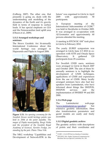
11(Lidberg, 2007). The o<strong>the</strong>r one, thatpresently is going on, deals with <strong>the</strong>understanding and modelling <strong>of</strong> <strong>the</strong>dynamics <strong>of</strong> <strong>the</strong> Earth and it's gravityfield in terms <strong>of</strong> response <strong>to</strong> surfaceloads. It has special emphasis on GIAand <strong>the</strong> Fennoscandian land uplift area(Olsson et al., 2009).1.11.3 Arranged workshops andseminarsThe Struve Geodetic Arc bi-annuallyInternational Conference about thisworld heritage was arranged inHaparanda and Pajala in August 2006.future" was organised in Gävle in April2009 with approximately 50participants.A European meeting <strong>of</strong> <strong>the</strong>International Subcommittee <strong>of</strong> CGSIC 32was held in S<strong>to</strong>ckholm in Oc<strong>to</strong>ber 2009.It was arranged in co-operation withAJ Geomatics and approximately 60persons attended <strong>the</strong> meeting.A meeting in RTCM SC-104 33 <strong>to</strong>ok placein Gävle in February 2010.The yearly EUREF symposium wasarranged in Gävle June 2-5 2010 in cooperationwith KTH and Onsala SpaceObserva<strong>to</strong>ry. It ga<strong>the</strong>red 129participants from 29 countries.For Swedish GNSS users, seminarswere arranged in Gävle in March 2007and Oc<strong>to</strong>ber 2009. The aim <strong>of</strong> <strong>the</strong>se biannuallyseminars is <strong>to</strong> highlight <strong>the</strong>development <strong>of</strong> GNSS techniques,applications <strong>of</strong> GNSS and experiencesfrom <strong>the</strong> use <strong>of</strong> GNSS. Many locallyarranged seminars have also had keyspeakers from Lantmäteriet, who haveinformed about things like SWEPOS,SWEPOS services and <strong>the</strong>implementation <strong>of</strong> SWEREF 99 and RH2000.Figure 1.11: An opening ceremony for <strong>the</strong>Swedish Struve world heritage points washeld in 2006 at <strong>the</strong> point Jupukka. Themayor <strong>of</strong> Pajala municipality, Bengt Niskaand <strong>the</strong> president <strong>of</strong> <strong>the</strong> Swedish RoyalAcademy <strong>of</strong> Sciences, Kerstin Fredga, arestanding by <strong>the</strong> pole. Pho<strong>to</strong>: Tõnu Viik.The <strong>NKG</strong> workshop "Capabilities andDevelopment <strong>of</strong> Network-RTK in <strong>the</strong>1.11.4 Web-pageThe Lantmäteriet web-page(www.lantmateriet.se/geodesi) hasextensive geodetic information. Herealso transformation parameters andgeoid models are easily and freelyaccessible.1.11.5 Digital geodetic archiveThe geodetic archive with descriptions<strong>of</strong> points and <strong>the</strong>ir coordinates and32CGSIC = Civil GPS Service Interface Committee33RTCM SC-104 = Radio Technical Commission forMaritime Services Special Committee No. 104