National Report of Sweden to the NKG General ... - Lantmäteriet
National Report of Sweden to the NKG General ... - Lantmäteriet
National Report of Sweden to the NKG General ... - Lantmäteriet

Create successful ePaper yourself
Turn your PDF publications into a flip-book with our unique Google optimized e-Paper software.
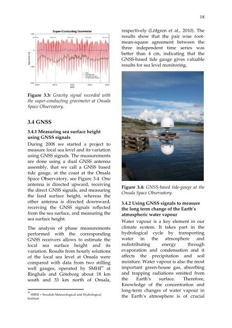
18respectively (Löfgren et al., 2010). Theresults show that <strong>the</strong> pair wise rootmean-squareagreement between <strong>the</strong>three independent time series wasbetter than 4 cm, indicating that <strong>the</strong>GNSS-based tide gauge gives valuableresults for sea level moni<strong>to</strong>ring.Figure 3.3: Gravity signal recorded with<strong>the</strong> super-conducting gravimeter at OnsalaSpace Observa<strong>to</strong>ry.3.4 GNSS3.4.1 Measuring sea surface heightusing GNSS signalsDuring 2008 we started a project <strong>to</strong>measure local sea level and its variationusing GNSS signals. The measurementsare done using a dual GNSS antennaassembly, that we call a GNSS basedtide gauge, at <strong>the</strong> coast at <strong>the</strong> OnsalaSpace Observa<strong>to</strong>ry, see Figure 3.4. Oneantenna is directed upward, receiving<strong>the</strong> direct GNSS signals, and measuring<strong>the</strong> land surface height, whereas <strong>the</strong>o<strong>the</strong>r antenna is directed downward,receiving <strong>the</strong> GNSS signals reflectedfrom <strong>the</strong> sea surface, and measuring <strong>the</strong>sea surface height.The analysis <strong>of</strong> phase measurementsperformed with <strong>the</strong> correspondingGNSS receivers allows <strong>to</strong> estimate <strong>the</strong>local sea surface height and itsvariation. Results from hourly solutions<strong>of</strong> <strong>the</strong> local sea level at Onsala werecompared with data from two stillingwell gauges, operated by SMHI 39atRinghals and Göteborg about 18 kmsouth and 33 km north <strong>of</strong> Onsala,39SMHI = Swedish Meteorological and HydrologicalInstituteFigure 3.4: GNSS-based tide-gauge at <strong>the</strong>Onsala Space Observa<strong>to</strong>ry.3.4.2 Using GNSS signals <strong>to</strong> measure<strong>the</strong> long term change <strong>of</strong> <strong>the</strong> Earth’satmospheric water vapourWater vapour is a key element in ourclimate system. It takes part in <strong>the</strong>hydrological cycle by transportingwater in <strong>the</strong> atmosphere andredistributing energy throughevaporation and condensation and itaffects <strong>the</strong> precipitation and soilmoisture. Water vapour is also <strong>the</strong> mostimportant green-house gas, absorbingand trapping radiations emitted from<strong>the</strong> Earth’s surface. Therefore,Knowledge <strong>of</strong> <strong>the</strong> concentration andlong-term changes <strong>of</strong> water vapour in<strong>the</strong> Earth’s atmosphere is <strong>of</strong> crucial