National Report of Sweden to the NKG General ... - Lantmäteriet
National Report of Sweden to the NKG General ... - Lantmäteriet
National Report of Sweden to the NKG General ... - Lantmäteriet

You also want an ePaper? Increase the reach of your titles
YUMPU automatically turns print PDFs into web optimized ePapers that Google loves.
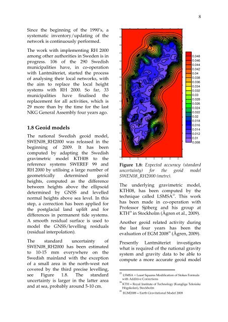
8Since <strong>the</strong> beginning <strong>of</strong> <strong>the</strong> 1990’s, asystematic inven<strong>to</strong>ry/updating <strong>of</strong> <strong>the</strong>network is continuously performed.The work with implementing RH 2000among o<strong>the</strong>r authorities in <strong>Sweden</strong> is inprogress. 106 <strong>of</strong> <strong>the</strong> 290 Swedishmunicipalities have, in co-operationwith Lantmäteriet, started <strong>the</strong> process<strong>of</strong> analysing <strong>the</strong>ir local networks, with<strong>the</strong> aim <strong>to</strong> replace <strong>the</strong> local heightsystems with RH 2000. So far, 33municipalities have finalised <strong>the</strong>replacement for all activities, which is29 more than by <strong>the</strong> time for <strong>the</strong> last<strong>NKG</strong> <strong>General</strong> Assembly four years ago.1.8 Geoid modelsThe national Swedish geoid model,SWEN08_RH2000 was released in <strong>the</strong>beginning <strong>of</strong> 2009. It has beencomputed by adapting <strong>the</strong> Swedishgravimetric model KTH08 <strong>to</strong> <strong>the</strong>reference systems SWEREF 99 andRH 2000 by utilising a large number <strong>of</strong>geometrically determined geoidheights, computed as <strong>the</strong> differencebetween heights above <strong>the</strong> ellipsoiddetermined by GNSS and levellednormal heights above sea level. In thisstep, a correction has been applied for<strong>the</strong> postglacial land uplift and fordifferences in permanent tide systems.A smooth residual surface is used <strong>to</strong>model <strong>the</strong> GNSS/levelling residuals(residual interpolation).The standard uncertainty <strong>of</strong>SWEN08_RH2000 has been estimated<strong>to</strong> 10-15 mm everywhere on <strong>the</strong>Swedish mainland with <strong>the</strong> exception<strong>of</strong> a small area in <strong>the</strong> north-west notcovered by <strong>the</strong> third precise levelling,see Figure 1.8. The standarduncertainty is larger in <strong>the</strong> latter areaand at sea, probably around 5-10 cm.706968676665646362616059585756555410 12 14 16 18 20 22 240.0480.0460.0440.0420.040.0380.0360.0340.0320.030.0280.0260.0240.0220.020.0180.0160.0140.0120.010.008Figure 1.8: Expected accuracy (standarduncertainty) for <strong>the</strong> geoid modelSWEN08_RH2000 (metre).The underlying gravimetric model,KTH08, has been computed by <strong>the</strong>technique called LSMSA 23 . This workhas been made in co-operation withPr<strong>of</strong>essor Sjöberg and his group atKTH 24 in S<strong>to</strong>ckholm (Ågren et al., 2009).Ano<strong>the</strong>r geoid related activity during<strong>the</strong> last four years has been <strong>the</strong>evaluation <strong>of</strong> EGM 2008 25 (Ågren, 2009).Presently Lantmäteriet investigateswhat is required <strong>of</strong> <strong>the</strong> national gravitysystem and gravity data <strong>to</strong> be able <strong>to</strong>compute a more accurate geoid model23LSMSA = Least Squares Modification <strong>of</strong> S<strong>to</strong>kes Formulawith Additive Corrections24KTH = Royal Institute <strong>of</strong> Technology (Kungliga TekniskaHögskolan), S<strong>to</strong>ckholm25EGM2008 = Earth Gravitational Model 2008