National Report of Sweden to the NKG General ... - Lantmäteriet
National Report of Sweden to the NKG General ... - Lantmäteriet
National Report of Sweden to the NKG General ... - Lantmäteriet

Create successful ePaper yourself
Turn your PDF publications into a flip-book with our unique Google optimized e-Paper software.
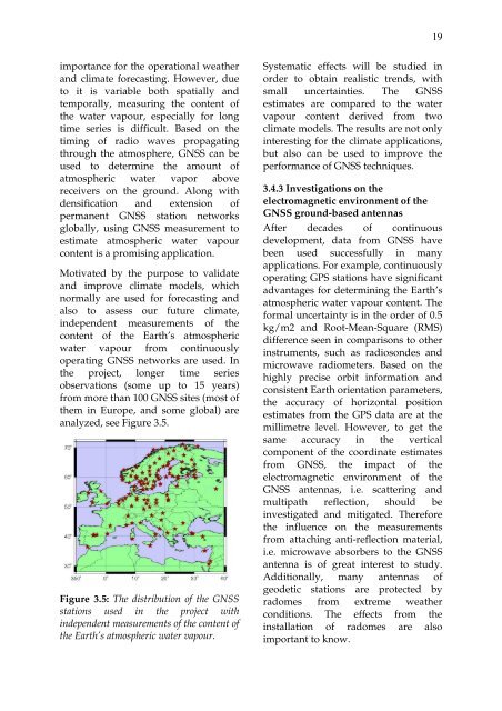
19importance for <strong>the</strong> operational wea<strong>the</strong>rand climate forecasting. However, due<strong>to</strong> it is variable both spatially andtemporally, measuring <strong>the</strong> content <strong>of</strong><strong>the</strong> water vapour, especially for longtime series is difficult. Based on <strong>the</strong>timing <strong>of</strong> radio waves propagatingthrough <strong>the</strong> atmosphere, GNSS can beused <strong>to</strong> determine <strong>the</strong> amount <strong>of</strong>atmospheric water vapor abovereceivers on <strong>the</strong> ground. Along withdensification and extension <strong>of</strong>permanent GNSS station networksglobally, using GNSS measurement <strong>to</strong>estimate atmospheric water vapourcontent is a promising application.Motivated by <strong>the</strong> purpose <strong>to</strong> validateand improve climate models, whichnormally are used for forecasting andalso <strong>to</strong> assess our future climate,independent measurements <strong>of</strong> <strong>the</strong>content <strong>of</strong> <strong>the</strong> Earth’s atmosphericwater vapour from continuouslyoperating GNSS networks are used. In<strong>the</strong> project, longer time seriesobservations (some up <strong>to</strong> 15 years)from more than 100 GNSS sites (most <strong>of</strong><strong>the</strong>m in Europe, and some global) areanalyzed, see Figure 3.5.Figure 3.5: The distribution <strong>of</strong> <strong>the</strong> GNSSstations used in <strong>the</strong> project withindependent measurements <strong>of</strong> <strong>the</strong> content <strong>of</strong><strong>the</strong> Earth’s atmospheric water vapour.Systematic effects will be studied inorder <strong>to</strong> obtain realistic trends, withsmall uncertainties. The GNSSestimates are compared <strong>to</strong> <strong>the</strong> watervapour content derived from twoclimate models. The results are not onlyinteresting for <strong>the</strong> climate applications,but also can be used <strong>to</strong> improve <strong>the</strong>performance <strong>of</strong> GNSS techniques.3.4.3 Investigations on <strong>the</strong>electromagnetic environment <strong>of</strong> <strong>the</strong>GNSS ground-based antennasAfter decades <strong>of</strong> continuousdevelopment, data from GNSS havebeen used successfully in manyapplications. For example, continuouslyoperating GPS stations have significantadvantages for determining <strong>the</strong> Earth’satmospheric water vapour content. Theformal uncertainty is in <strong>the</strong> order <strong>of</strong> 0.5kg/m2 and Root-Mean-Square (RMS)difference seen in comparisons <strong>to</strong> o<strong>the</strong>rinstruments, such as radiosondes andmicrowave radiometers. Based on <strong>the</strong>highly precise orbit information andconsistent Earth orientation parameters,<strong>the</strong> accuracy <strong>of</strong> horizontal positionestimates from <strong>the</strong> GPS data are at <strong>the</strong>millimetre level. However, <strong>to</strong> get <strong>the</strong>same accuracy in <strong>the</strong> verticalcomponent <strong>of</strong> <strong>the</strong> coordinate estimatesfrom GNSS, <strong>the</strong> impact <strong>of</strong> <strong>the</strong>electromagnetic environment <strong>of</strong> <strong>the</strong>GNSS antennas, i.e. scattering andmultipath reflection, should beinvestigated and mitigated. Therefore<strong>the</strong> influence on <strong>the</strong> measurementsfrom attaching anti-reflection material,i.e. microwave absorbers <strong>to</strong> <strong>the</strong> GNSSantenna is <strong>of</strong> great interest <strong>to</strong> study.Additionally, many antennas <strong>of</strong>geodetic stations are protected byradomes from extreme wea<strong>the</strong>rconditions. The effects from <strong>the</strong>installation <strong>of</strong> radomes are alsoimportant <strong>to</strong> know.