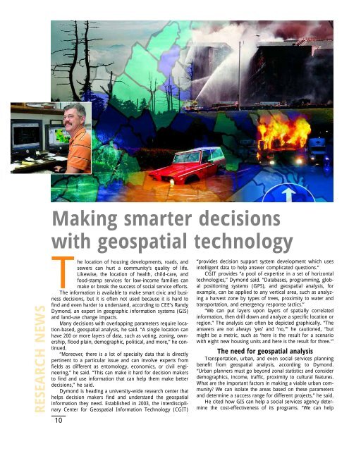
Making smarter decisionswith geospatial technologyRESEARCH NEWSThe location of housing developments, roads, <strong>and</strong>sewers can hurt a community’s quality of life.Likewise, the location of health, child-care, <strong>and</strong>food-stamp services for low-income families canmake or break the success of social service efforts.The information is available to make smart civic <strong>and</strong> businessdecisions, but it is often not used because it is hard tofind <strong>and</strong> even harder to underst<strong>and</strong>, according to CEE’s R<strong>and</strong>yDymond, an expert in geographic information systems (GIS)<strong>and</strong> l<strong>and</strong>-use change impacts.Many decisions with overlapping parameters require location-based,geospatial analysis, he said. “A single location canhave 200 or more layers of data, such as voting, zoning, ownership,flood plain, demographic, political, <strong>and</strong> more,” he continued.“Moreover, there is a lot of specialty data that is directlypertinent to a particular issue <strong>and</strong> can involve experts fromfields as different as entomology, economics, or civil engineering,”he said. “This can make it hard for decision makersto find <strong>and</strong> use information that can help them make betterdecisions,” he said.Dymond is heading a university-wide research center thathelps decision makers find <strong>and</strong> underst<strong>and</strong> the geospatialinformation they need. Established in 2003, the interdisciplinaryCenter for Geospatial Information Technology (CGIT)10“provides decision support system development which usesintelligent data to help answer complicated questions.”CGIT provides “a pool of expertise in a set of horizontaltechnologies,” Dymond said. “Databases, programming, globalpositioning systems (GPS), <strong>and</strong> geospatial analysis, forexample, can be applied to any vertical area, such as analyzinga harvest zone by types of trees, proximity to water <strong>and</strong>transportation, <strong>and</strong> emergency response tactics.”“We can put layers upon layers of spatially correlatedinformation, then drill down <strong>and</strong> analyze a specific location orregion.” The analysis can often be depicted graphically. “Theanswers are not always ‘yes’ <strong>and</strong> ‘no,’” he cautioned, “butmight be a metric, such as ‘here is the result for a scenariowith eight new housing units <strong>and</strong> here is the result for three.’”The need for geospatial analysisTransportation, urban, <strong>and</strong> even social services planningbenefit from geospatial analysis, according to Dymond.“Urban planners must go beyond zonal statistics <strong>and</strong> considerdemographics, income, traffic, proximity to cultural features.What are the important factors in making a viable urban community?We can isolate the areas based on these parameters<strong>and</strong> determine a success range for different projects,” he said.He cited how GIS can help a social services agency determinethe cost-effectiveness of its programs. “We can help
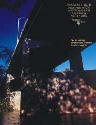
Left: Using layers of location-basedinformation, the Center for GeospatialInformation Technology (CGIT) hasbeen helping Virginia municipalitiesassess their risks due to floods, winds,fires, earthquake, <strong>and</strong> human-causeddisasters. Inset left: R<strong>and</strong>y Dymond,CGIT director.them map where their clients live, what businesses providethe clients with health care, child care <strong>and</strong> food-stampredemption. We can help ask <strong>and</strong> answer questions, such asdoes an underprivileged client need to travel five miles withno public transportation to get child care,” Dymond said.Hazard MitigationCGIT’s main research areas include homel<strong>and</strong> security,public health, transportation <strong>and</strong> infrastructure, wirelesscommunications, environmental management, <strong>and</strong> smartgrowth. <strong>Environmental</strong> projects have included applicationsinvolving the spread of gypsy moths, coal mine reclamation,watershed water quality, <strong>and</strong> web-enabled spatial decisionsupport systems for watershed managers.Infrastructure projects have included designing the locationof wireless telecommunication systems, l<strong>and</strong> mine terrainmodeling for de-mining operations, <strong>and</strong> earthquake riskassessment.CGIT’s largest application to date has involved hazardmitigation for the Virginia Department of EmergencyManagement. The Federal Emergency Management Agency(FEMA) is requiring each municipality to prepare an all-hazardplan that considers all the facilities owned by any levelof government. CGIT has been involved with a number ofthe plans across Virginia, evaluating the risks for hazardsincluding fire, floods, tornados, high winds, earthquakes,hurricanes, <strong>and</strong> human-caused disasters. “In Virginia alone,there are 13,000 facilities that need to be evaluated,”Dymond said.Geographic DiversityCGIT has facilities on both the Blacksburg campus <strong>and</strong>in Alex<strong>and</strong>ria, Va. “Our research presence in Northern Virginiaenables us to interface with the many federal agenciesthat provide data <strong>and</strong> that rely on GIS <strong>and</strong> related technology,”Dymond said. The Northern Virginia facility is headedby Kitty Hancock.Since its inception, CGIT has grown from a loose associationof faculty researchers to a full-time staff of four, alongwith 3 part-time staff. The steady growth of the center doesnot surprise Dymond. “Nearly all fields of commerce in theworld today are using geospatial data to increase productivity.As a source of multidisciplinary geospatial expertise, weexpect to provide a variety of organizations with the informationthey need to weigh the tradeoffs <strong>and</strong> implications oftheir decisions.”Hancock joins facultyKathleen Hancock has joined CEE in VirginiaTech’s National Capitol Region as an associateprofessor <strong>and</strong> associate director of the Centerfor Geospatial Information Technology (CGIT).An expert in geospatial information systems(GIS) for transportation, she comes from the University ofMassachusetts at Amherst, where she was an associate professor<strong>and</strong> the transportation graduate program coordinator intheir CEE department. She also served as associate director ofthe UMass Transportation Center <strong>and</strong> as director of MassSAFE,the research <strong>and</strong> technical support center for the MassachusettsGovernor’s Highway Safety Bureau.Hancock’s work at UMass spanned the areas of freightplanning <strong>and</strong> operations, transit planning, intelligent transportationsystems, <strong>and</strong> highway safety. Her accomplishmentsinclude coordination of a GIS framework for national transportationpolicy <strong>and</strong> planning tasks, development of a crashdata warehouse <strong>and</strong> user interface for Massachusetts, <strong>and</strong>development of a multi-network approach for assigningfreight to transportation networks which integrates business<strong>and</strong> travel information, supply chain management, <strong>and</strong> transportationplanning techniques.As the Northern Virginia coordinator for CGIT, Hancockplans to act as a team builder for multidisciplinary projects<strong>and</strong> to serve as a Virginia Tech contact with federal agenciesfor faculty in Blacksburg.“I hope to find the larger projectswhere Tech’s cross-disciplinary spatial expertise can contributeto some of our big issues today,”she said.Hancock willalso contribute her expertise in transportation <strong>and</strong> infrastructuremanagement using spatial analysis to CGIT,as well as provideacademic support in GIS <strong>and</strong> CAD for <strong>Civil</strong> <strong>Engineering</strong>in the Northern Virginia Graduate program.Before joining UMass in 1995, Hancock was a researchassistant professor at V<strong>and</strong>erbilt University, where she hadearned her doctoral <strong>and</strong> master’s degrees in 1994 <strong>and</strong> 1991respectively. Her professional experience includes a partnerposition with Momentum <strong>Engineering</strong>, Inc. in Nashville,Tenn., as well as research positions with the Scientex Corp. inWashington, DC <strong>and</strong> Southwest Research Institute in SanAntonio, Texas. She earned a BSCE from Colorado StateUniversity in 1982 <strong>and</strong> an AAS degree in architectural technologyfrom Del Mar College, Corpus Christi,Texas.11FACULTY NEWS