Bloomsbury Auctions
Bloomsbury Auctions
Bloomsbury Auctions

You also want an ePaper? Increase the reach of your titles
YUMPU automatically turns print PDFs into web optimized ePapers that Google loves.
66<br />
BLOOMSBURY AUCTIONS<br />
eA s T e r n eu r o p e<br />
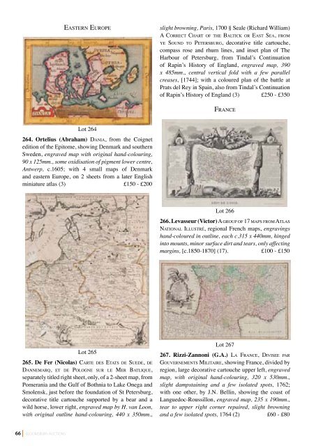
Lot 264<br />
264. Ortelius (Abraham) dA n i A, from the Coignet<br />
edition of the Epitome, showing Denmark and southern<br />
Sweden, engraved map with original hand-colouring,<br />
90 x 125mm., some oxidisation of pigment lower centre,<br />
Antwerp, c.1605; with 4 small maps of Denmark<br />
and eastern Europe, on 2 sheets from a later English<br />
miniature atlas (3) £150 - £200<br />
Lot 265<br />
265. De Fer (Nicolas) cA rT e d e s eT AT s d e su e d e, d e<br />
dA n n e M A r Q, e T d e po l o g n e s u r l e Me r bAT l i Q u e,<br />
separately titled right sheet, only, of a 2-sheet map, from<br />
Pomerania and the Gulf of Bothnia to Lake Onega and<br />
Smolensk, just before the foundation of St Petersburg,<br />
decorative title cartouche supported by a bear and a<br />
wild horse, lower right, engraved map by H. van Loon,<br />
with original outline hand-colouring, 440 x 350mm.,<br />
slight browning, Paris, 1700 § Seale (Richard William)<br />
A co r r e c T ch A rT o f T h e bA lT i c K o r eA s T se A, f r o M<br />
y e so u n d To pe T e r s b u r g, decorative title cartouche,<br />
compass rose and rhum lines, and inset plan of The<br />
Harbour of Petersburg, from Tindal’s Continuation<br />
of Rapin’s History of England, engraved map, 390<br />
x 485mm., central vertical fold with a few parallel<br />
creases, [1744]; with a coloured plan of the battle at<br />
Prats del Rey in Spain, also from Tindal’s Continuation<br />
of Rapin’s History of England (3) £250 - £350<br />
fr A n c e<br />
Lot 266<br />
266. Levasseur (Victor) A g r o u p o f 17 M A p s f r o M AT l A s<br />
nAT i o n A l il l u s T r é, regional French maps, engravings<br />
hand-coloured in outline, each c.315 x 440mm, hinged<br />
into mounts, minor surface dirt and tears, only affecting<br />
margins, [c.1850-1870] (17). £100 - £150<br />
Lot 267<br />
267. Rizzi-Zannoni (G.A.) lA fr A n c e, divisee pA r<br />
go u v e r n e M e n T s MiliTAire, showing France, divided by<br />
region, large decorative cartouche upper left, engraved<br />
map, with original hand-colouring, 320 x 530mm.,<br />
slight dampstaining and a few isolated spots, 1762;<br />
with one other, by J.N. Bellin, showing the coast of<br />
Languedoc-Roussillon, engraved map, 235 x 190mm.,<br />
tear to upper right corner repaired, slight browning<br />
and a few isolated spots, 1764 (2) £60 - £80