Bloomsbury Auctions
Bloomsbury Auctions
Bloomsbury Auctions

Create successful ePaper yourself
Turn your PDF publications into a flip-book with our unique Google optimized e-Paper software.
82<br />
BLOOMSBURY AUCTIONS<br />
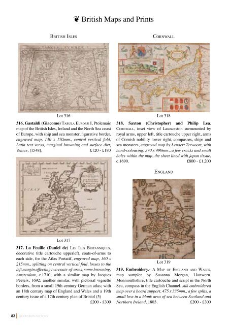
briTish is l e s<br />
Lot 316<br />
316. Gastaldi (Giacomo) TA b u l A eu r o p æ i, Ptolemaic<br />
map of the British Isles, Ireland and the North Sea coast<br />
of Europe, with ship and sea monster, figurative border,<br />
engraved map, 130 x 170mm., central vertical fold,<br />
Latin text verso, marginal browning and surface dirt,<br />
Venice, [1548]. £120 - £180<br />
Lot 317<br />
317. La Feuille (Daniel de) le s iles bri TA n n i Q u e s,<br />
decorative title cartouche upperleft, coats-of-arms to<br />
each side, for the Atlas Portatif, engraved map, 160 x<br />
215mm., splitting on central vertical fold, losses to the<br />
left margin affecting two coats-of-arms, some browning,<br />
Amsterdam, c.1710; with a similar map by Jacques<br />
Peeters, 1692; another similar, with pictorial vignette<br />
borders, from a small 19th century German atlas; with<br />
an 18th century map of England and Wales and a 19th<br />
century issue of a 17th century plan of Bristol (5)<br />
£200 - £300<br />
❦ British Maps and Prints<br />
co r n wA l l<br />
Lot 318<br />
318. Saxton (Christopher) and Philip Lea.<br />
co r n wA l l, inset view of Launceston surmounted by<br />
royal arms, upper left, title cartouche upper right, arms<br />
of Cornish nobility lower right, compasses, ships and<br />
sea monsters, engraved map by Lenaert Terwoort, with<br />
hand-colouring, 370 x 490mm., a few cracks and small<br />
holes within the map, the sheet lined with japan tissue,<br />
c.1690. £800 - £1,200<br />
en g l A n d<br />
Lot 319<br />
319. Embroidery.- A MA p o f en g l A n d A n d wA l e s,<br />
map sampler by Susanna Morgan, Llanwern,<br />
Monmouthshire, title cartouche and script in the North<br />
Sea, compass in the English Channel, silk embroidered<br />
map over a board support, 475 x 335mm., a few splits, a<br />
small loss in a blank area of sea between Scotland and<br />
Northern Ireland, 1803. £200 - £300