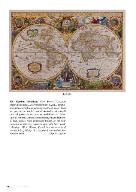
78 308. Hondius (Henricus) no vA To T i u s Te r r A r u M o r b i s ge o g r A p h i c A A c hy d r o g r A p h i c A TA b u l A, doublehemisphere world map showing California as an island and part of the north coast of Australia, with small celestial globe above, portrait medallions of Julius Caesar, Ptolemy, Gerard Mercator and Jodocus Hondius in each corner, with allegorical figures of the four elements in between, engraved map with later handcolouring, 380 x 540mm., French text verso, central vertical fold, [Shirley 336, 2nd state], Amsterdam, Jan Jansson, 1641. £3,000 - £4,000 BLOOMSBURY AUCTIONS Lot 308
Lot 309 309. Mercator (Gerard) [TA b u l A e ge o g r A p h i c A e], 17 maps only, with 16 showing parts of the British Isles and Ireland, including ‘Anglia, Scotia et Hibernia’, ‘Anglia Regnum’, and ‘Irlandiae regnum’, engravings, disbound, each c.360 x 470mm, all with Latin text on verso, central vertical folds, some repairs to folds and margins, occasional surface dirt, handling creases, spotting and browning, some damp-staining, [1595 or later] (17). £1,200 - £1,800 Lot 310 310. Ortelius (Abraham) Ae v i ve T e r i s, Ty p u s ge o g r A p h i c u s, classical world map within an elaborate strapwork border containing title above and the 4 known continents in corner medallions, engraved map with hand-colouring, 310 x 440mm., Latin text verso with page number 1, repairs to central vertical fold, [vdB 186], Amsterdam, 1592. £300 - £400 Lot 311 311. Philip (George and Son) philips’ pl A n i s p h e r e s h o w i n g T h e pr i n c i pA l sTA r s visible f o r e v e ry h o u r in T h e y e A r, smaller 5” diameter celestial chart on a volvelle set within an ornate device, Explanation text panel verso, printed in gold and white on paper, mounted on circular card within quadrangular morocco gilt device, 165 x 165mm. overall, minor wear to extremities, n.d., c.1920s. £60 - £80 Lot 312 312. Rogers (William) do u b l e-h e M i s p h e r e w o r l d M A p , with strapwork surround, the name Iehovah upper centre, for one of the title-pages of Linschoten’s Voyages, engraved map wih hand-colouring, 80 x 120mm., slight browning, [Shirley 216], John Wolfe, 1598 § Schreiber (Johann) Globus Terrestris, doublehemisphere world map, title banderole above, planetary systems upper and lower centre, key to continental abbreviations below, engraved map with original handcolouring, 180 x 255mm., Leipzig, c.1750; with Histoire des Gomerites, ou Celtes, map of ancient Europe by Claude Buy de Mornas, and Orbis Veteribus Notus, by Neele (4) £250 - £350 BLOOMSBURY AUCTIONS 79