Bloomsbury Auctions
Bloomsbury Auctions
Bloomsbury Auctions

You also want an ePaper? Increase the reach of your titles
YUMPU automatically turns print PDFs into web optimized ePapers that Google loves.
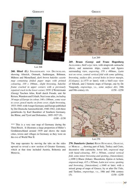
ge r M A n y<br />
Lot 268<br />
268. Hözel (E.) sT r A s s e n K A rT e v o n de u T s c h l A n d,<br />
showing Altreich, Ostmark, Sudetengau, Böhmen,<br />
Mähren and Memelland, dark brown bakelite casette<br />
map containing folded paper maps with printed<br />
colouring, 330 x 180mm., slight browning, bakelite<br />
frame cracked in upper corners with a previously<br />
repaired crack in the lower corner, 1939 § Westermann<br />
(Georg) Taschen Atlas, Kraft durch Freude, amt für<br />
Reisen, Wandern und Urlaub, Nazi issue atlas, including<br />
34 maps of Europe in colour, 140 x 100mm., some wear<br />
to cover, pencil marks on front cover, slight browning,<br />
1933-1945; with 4 maps Germany and Europe published<br />
by Der Deutsche Automobilclub, 1940-1942, with three<br />
guidebooks by Karl Baedeker of Southern Germany,<br />
the Rhine, and Tyrol and Dolomites, 1895-1927 (9).<br />
£100 - £150<br />
*** This is a very rare map of Germany during the<br />
Third Reich. It illustrates a large proportion of Hitler’s<br />
Großdeutschland around 1939 and shows the main<br />
cities, towns and villages in Germany as they were on<br />
the eve of World War II.<br />
The map operates by moving the tabs on the sides<br />
upward to reveal a new section of Greater Germany,<br />
which at that time included Austria, Bohemia and<br />
Moravia.<br />
gr e e c e<br />
Lot 269<br />
269. Braun (Georg) and Franz Hogenberg<br />
Al e x A n d r i A, bird’s-eye view, with strapwork cartouche<br />
above, and numerous ships, camels and figures<br />
surrounding view, engraving, 370 x 480mm., Latin<br />
text on verso, central vertical fold with some splitting,<br />
browning, surface dirt, several holes in lower margin,<br />
[Cologne], [c.1575 or later]; with a bird’s-eye view<br />
of Sibenik, and 2 historic maps of Europe, one by De<br />
Vaugondy, engravings, v.s., some surface dirt, 18th<br />
and19th century (4). £150 - £250<br />
Lot 270<br />
270. Danckerts (Justus) re g n i hun g A r i A e, gr A e c i A e,<br />
e T Mo r e A e ..., showing part of Italy, Turkey and Crete,<br />
decorative title cartouche, lower left, engraved map<br />
with hand-colouring, 505 x 585mm, central vertical<br />
fold, some minor browning and spotting, [Amsterdam],<br />
c,1690 § Blaeu (Johan). Macedonia, Epirus et Achaia,<br />
engraved map, 415 x 505mm, Latin text verso, spotting<br />
and browning, [Amsterdam], c.1640 or later; with a<br />
mixed group of maps of Greece, by or after De l’Isle,<br />
and Tardieu, engravings, v.s., 18th and 19th century<br />
(5). £150 - £250<br />
BLOOMSBURY AUCTIONS<br />
67