- Page 1 and 2:
FREE FLOWREACHING WATER SECURITY TH
- Page 3 and 4:
DISCLAIMERThe designations employed
- Page 5 and 6:
ForewordIRINA BOKOVA, DIRECTOR-GENE
- Page 7 and 8:
ContentsAcknowledgements ..........
- Page 9 and 10:
ContentsVLEGAL FRAMEWORK AT THE NAT
- Page 11 and 12:
MR JÁNOS ÁDER, PRESIDENT OF THE R
- Page 13 and 14:
FREE FLOWWater security through sci
- Page 15 and 16:
FREE FLOWThe UNESCO Water FamilyIma
- Page 17 and 18:
FREE FLOWImage: © Alexander Otte/U
- Page 19 and 20:
IWater Diplomacy
- Page 21 and 22:
WATER DIPLOMACYand Scheldt, and for
- Page 23 and 24:
WATER DIPLOMACYdrinking water and i
- Page 25 and 26:
WATER DIPLOMACYlivelihoods. Inland
- Page 27 and 28:
WATER DIPLOMACYIn the Lake Titicaca
- Page 29 and 30:
WATER DIPLOMACYviolence, loss of ho
- Page 31 and 32:
WATER DIPLOMACYTransboundary water
- Page 33 and 34:
WATER DIPLOMACYImage: K G HortleA M
- Page 35 and 36:
WATER DIPLOMACYThe Nile Basin Initi
- Page 37 and 38:
WATER DIPLOMACYImage: Eastern Nile
- Page 39 and 40:
IITransboundaryWater Management
- Page 41 and 42:
TRANSBOUNDARY WATER MANAGEMENTThe r
- Page 43 and 44:
TRANSBOUNDARY WATER MANAGEMENTA sum
- Page 45 and 46:
TRANSBOUNDARY WATER MANAGEMENTSusta
- Page 47 and 48:
TRANSBOUNDARY WATER MANAGEMENTImage
- Page 49 and 50:
TRANSBOUNDARY WATER MANAGEMENTTrans
- Page 51 and 52:
TRANSBOUNDARY WATER MANAGEMENTtenti
- Page 53 and 54:
TRANSBOUNDARY WATER MANAGEMENTCoope
- Page 55 and 56:
TRANSBOUNDARY WATER MANAGEMENTImage
- Page 57 and 58:
TRANSBOUNDARY WATER MANAGEMENTEffic
- Page 59 and 60:
TRANSBOUNDARY WATER MANAGEMENTImage
- Page 61 and 62:
TRANSBOUNDARY WATER MANAGEMENTShari
- Page 63:
TRANSBOUNDARY WATER MANAGEMENTImage
- Page 66 and 67:
TRANSBOUNDARY WATER MANAGEMENTMap o
- Page 68 and 69:
TRANSBOUNDARY WATER MANAGEMENTis no
- Page 70 and 71:
TRANSBOUNDARY WATER MANAGEMENTThe M
- Page 72 and 73:
TRANSBOUNDARY WATER MANAGEMENTThe M
- Page 74 and 75:
TRANSBOUNDARY WATER MANAGEMENTParti
- Page 76 and 77:
TRANSBOUNDARY WATER MANAGEMENTOne m
- Page 78 and 79:
TRANSBOUNDARY WATER MANAGEMENTFirst
- Page 80 and 81:
TRANSBOUNDARY WATER MANAGEMENTImple
- Page 82 and 83:
TRANSBOUNDARY WATER MANAGEMENTThe n
- Page 84 and 85:
TRANSBOUNDARY WATER MANAGEMENTNatur
- Page 86 and 87:
TRANSBOUNDARY WATER MANAGEMENTRegio
- Page 88 and 89:
TRANSBOUNDARY WATER MANAGEMENTTrans
- Page 90 and 91:
TRANSBOUNDARY WATER MANAGEMENTConfe
- Page 92 and 93:
TRANSBOUNDARY WATER MANAGEMENTTrans
- Page 94 and 95:
TRANSBOUNDARY WATER MANAGEMENTImage
- Page 96 and 97:
TRANSBOUNDARY WATER MANAGEMENTInter
- Page 98 and 99:
TRANSBOUNDARY WATER MANAGEMENTThe m
- Page 100 and 101:
WATER EDUCATION AND INSTITUTIONAL D
- Page 102 and 103:
WATER EDUCATION AND INSTITUTIONAL D
- Page 104 and 105:
WATER EDUCATION AND INSTITUTIONAL D
- Page 106 and 107:
WATER EDUCATION AND INSTITUTIONAL D
- Page 108 and 109:
WATER EDUCATION AND INSTITUTIONAL D
- Page 110 and 111:
WATER EDUCATION AND INSTITUTIONAL D
- Page 112 and 113:
WATER EDUCATION AND INSTITUTIONAL D
- Page 114 and 115:
WATER EDUCATION AND INSTITUTIONAL D
- Page 116 and 117:
WATER EDUCATION AND INSTITUTIONAL D
- Page 118 and 119:
WATER EDUCATION AND INSTITUTIONAL D
- Page 120 and 121:
WATER EDUCATION AND INSTITUTIONAL D
- Page 122 and 123:
WATER EDUCATION AND INSTITUTIONAL D
- Page 124 and 125:
WATER EDUCATION AND INSTITUTIONAL D
- Page 126 and 127:
WATER EDUCATION AND INSTITUTIONAL D
- Page 128 and 129:
WATER EDUCATION AND INSTITUTIONAL D
- Page 130 and 131:
WATER EDUCATION AND INSTITUTIONAL D
- Page 132 and 133:
WATER EDUCATION AND INSTITUTIONAL D
- Page 134 and 135:
WATER EDUCATION AND INSTITUTIONAL D
- Page 136 and 137:
WATER EDUCATION AND INSTITUTIONAL D
- Page 138 and 139:
WATER EDUCATION AND INSTITUTIONAL D
- Page 140 and 141:
WATER EDUCATION AND INSTITUTIONAL D
- Page 142 and 143:
WATER EDUCATION AND INSTITUTIONAL D
- Page 144 and 145:
WATER EDUCATION AND INSTITUTIONAL D
- Page 146 and 147:
WATER EDUCATION AND INSTITUTIONAL D
- Page 148 and 149:
WATER EDUCATION AND INSTITUTIONAL D
- Page 150 and 151:
WATER EDUCATION AND INSTITUTIONAL D
- Page 152 and 153:
WATER EDUCATION AND INSTITUTIONAL D
- Page 154 and 155:
IVFinancing Cooperation
- Page 156 and 157:
FINANCING COOPERATIONventions and s
- Page 158 and 159:
FINANCING COOPERATIONPoverty reduct
- Page 160 and 161:
FINANCING COOPERATIONCollaboration
- Page 162 and 163:
FINANCING COOPERATIONWaterCredit: s
- Page 164 and 165:
FINANCING COOPERATIONImage: Water.o
- Page 166 and 167:
FINANCING COOPERATIONGovernance for
- Page 168 and 169:
FINANCING COOPERATIONImage: © Cuen
- Page 170 and 171:
LEGAL FRAMEWORK AT THE NATIONAL/INT
- Page 172 and 173:
LEGAL FRAMEWORK AT THE NATIONAL/INT
- Page 174 and 175:
LEGAL FRAMEWORK AT THE NATIONAL/INT
- Page 176 and 177:
LEGAL FRAMEWORK AT THE NATIONAL/INT
- Page 178 and 179:
LEGAL FRAMEWORK AT THE NATIONAL/INT
- Page 180 and 181:
LEGAL FRAMEWORK AT THE NATIONAL/INT
- Page 182 and 183:
LEGAL FRAMEWORK AT THE NATIONAL/INT
- Page 184 and 185:
VIWater Cooperation,Sustainability
- Page 186 and 187:
WATER COOPERATION, SUSTAINABILITY A
- Page 188 and 189:
WATER COOPERATION, SUSTAINABILITY A
- Page 190 and 191:
WATER COOPERATION, SUSTAINABILITY A
- Page 192 and 193: WATER COOPERATION, SUSTAINABILITY A
- Page 194 and 195: WATER COOPERATION, SUSTAINABILITY A
- Page 196 and 197: WATER COOPERATION, SUSTAINABILITY A
- Page 198 and 199: WATER COOPERATION, SUSTAINABILITY A
- Page 200 and 201: WATER COOPERATION, SUSTAINABILITY A
- Page 202 and 203: WATER COOPERATION, SUSTAINABILITY A
- Page 204 and 205: WATER COOPERATION, SUSTAINABILITY A
- Page 206 and 207: WATER COOPERATION, SUSTAINABILITY A
- Page 208 and 209: WATER COOPERATION, SUSTAINABILITY A
- Page 210 and 211: WATER COOPERATION, SUSTAINABILITY A
- Page 212 and 213: WATER COOPERATION, SUSTAINABILITY A
- Page 214 and 215: WATER COOPERATION, SUSTAINABILITY A
- Page 216 and 217: WATER COOPERATION, SUSTAINABILITY A
- Page 218 and 219: WATER COOPERATION, SUSTAINABILITY A
- Page 220 and 221: WATER COOPERATION, SUSTAINABILITY A
- Page 222 and 223: WATER COOPERATION, SUSTAINABILITY A
- Page 224 and 225: WATER COOPERATION, SUSTAINABILITY A
- Page 226 and 227: WATER COOPERATION, SUSTAINABILITY A
- Page 228 and 229: WATER COOPERATION, SUSTAINABILITY A
- Page 230 and 231: WATER COOPERATION, SUSTAINABILITY A
- Page 232 and 233: WATER COOPERATION, SUSTAINABILITY A
- Page 234 and 235: WATER COOPERATION, SUSTAINABILITY A
- Page 236 and 237: WATER COOPERATION, SUSTAINABILITY A
- Page 238 and 239: WATER COOPERATION, SUSTAINABILITY A
- Page 240 and 241: WATER COOPERATION, SUSTAINABILITY A
- Page 244 and 245: WATER COOPERATION, SUSTAINABILITY A
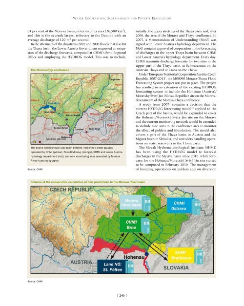
- Page 246 and 247: WATER COOPERATION, SUSTAINABILITY A
- Page 248 and 249: WATER COOPERATION, SUSTAINABILITY A
- Page 250 and 251: WATER COOPERATION, SUSTAINABILITY A
- Page 252 and 253: VIIEconomic Developmentand Water
- Page 254 and 255: ECONOMIC DEVELOPMENT AND WATERAmeri
- Page 256 and 257: ECONOMIC DEVELOPMENT AND WATERnatio
- Page 258 and 259: ECONOMIC DEVELOPMENT AND WATERImage
- Page 260 and 261: ECONOMIC DEVELOPMENT AND WATERAdvan
- Page 262 and 263: ECONOMIC DEVELOPMENT AND WATERLaw N
- Page 264 and 265: ECONOMIC DEVELOPMENT AND WATERWater
- Page 266 and 267: ECONOMIC DEVELOPMENT AND WATERRiver
- Page 268 and 269: ECONOMIC DEVELOPMENT AND WATERPUB S
- Page 270 and 271: ECONOMIC DEVELOPMENT AND WATERImage
- Page 272 and 273: ECONOMIC DEVELOPMENT AND WATERTowar
- Page 274 and 275: ECONOMIC DEVELOPMENT AND WATERbio-m
- Page 276 and 277: ECONOMIC DEVELOPMENT AND WATERInteg
- Page 278 and 279: ECONOMIC DEVELOPMENT AND WATEREstim
- Page 280 and 281: ECONOMIC DEVELOPMENT AND WATERWater
- Page 282 and 283: ECONOMIC DEVELOPMENT AND WATER65 hm
- Page 284 and 285: INTERNATIONAL COOPERATION ON WATER
- Page 286 and 287: INTERNATIONAL COOPERATION ON WATER
- Page 288 and 289: INTERNATIONAL COOPERATION ON WATER
- Page 290 and 291: INTERNATIONAL COOPERATION ON WATER
- Page 292 and 293:
INTERNATIONAL COOPERATION ON WATER
- Page 294 and 295:
INTERNATIONAL COOPERATION ON WATER
- Page 296 and 297:
INTERNATIONAL COOPERATION ON WATER
- Page 298 and 299:
INTERNATIONAL COOPERATION ON WATER
- Page 300 and 301:
INTERNATIONAL COOPERATION ON WATER
- Page 302 and 303:
INTERNATIONAL COOPERATION ON WATER
- Page 304 and 305:
INTERNATIONAL COOPERATION ON WATER
- Page 306 and 307:
INTERNATIONAL COOPERATION ON WATER
- Page 308 and 309:
INTERNATIONAL COOPERATION ON WATER
- Page 310 and 311:
INTERNATIONAL COOPERATION ON WATER
- Page 312 and 313:
INTERNATIONAL COOPERATION ON WATER
- Page 314 and 315:
INTERNATIONAL COOPERATION ON WATER
- Page 316 and 317:
INTERNATIONAL COOPERATION ON WATER
- Page 318 and 319:
INTERNATIONAL COOPERATION ON WATER
- Page 320 and 321:
INTERNATIONAL COOPERATION ON WATER
- Page 322 and 323:
INTERNATIONAL COOPERATION ON WATER
- Page 324 and 325:
Notes and ReferencesI.Water Diploma
- Page 326 and 327:
Notes and ReferencesIII.Water Educa
- Page 328 and 329:
Notes and ReferencesManaging water,
- Page 330 and 331:
Notes and References2. Alcamo, J (2