

222893e
222893e
222893e

You also want an ePaper? Increase the reach of your titles
YUMPU automatically turns print PDFs into web optimized ePapers that Google loves.
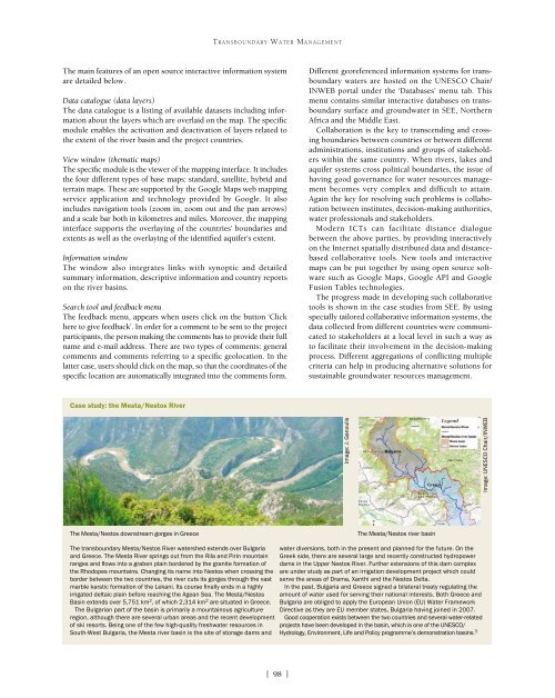
TRANSBOUNDARY WATER MANAGEMENTThe main features of an open source interactive information systemare detailed below.Data catalogue (data layers)The data catalogue is a listing of available datasets including informationabout the layers which are overlaid on the map. The specificmodule enables the activation and deactivation of layers related tothe extent of the river basin and the project countries.View window (thematic maps)The specific module is the viewer of the mapping interface. It includesthe four different types of base maps: standard, satellite, hybrid andterrain maps. These are supported by the Google Maps web mappingservice application and technology provided by Google. It alsoincludes navigation tools (zoom in, zoom out and the pan arrows)and a scale bar both in kilometres and miles. Moreover, the mappinginterface supports the overlaying of the countries’ boundaries andextents as well as the overlaying of the identified aquifer’s extent.Information windowThe window also integrates links with synoptic and detailedsummary information, descriptive information and country reportson the river basins.Search tool and feedback menuThe feedback menu, appears when users click on the button ‘Clickhere to give feedback’. In order for a comment to be sent to the projectparticipants, the person making the comments has to provide their fullname and e-mail address. There are two types of comments: generalcomments and comments referring to a specific geolocation. In thelatter case, users should click on the map, so that the coordinates of thespecific location are automatically integrated into the comments form.Different georeferenced information systems for transboundarywaters are hosted on the UNESCO Chair/INWEB portal under the ‘Databases’ menu tab. Thismenu contains similar interactive databases on transboundarysurface and groundwater in SEE, NorthernAfrica and the Middle East.Collaboration is the key to transcending and crossingboundaries between countries or between differentadministrations, institutions and groups of stakeholderswithin the same country. When rivers, lakes andaquifer systems cross political boundaries, the issue ofhaving good governance for water resources managementbecomes very complex and difficult to attain.Again the key for resolving such problems is collaborationbetween institutes, decision-making authorities,water professionals and stakeholders.Modern ICTs can facilitate distance dialoguebetween the above parties, by providing interactivelyon the Internet spatially distributed data and distancebasedcollaborative tools. New tools and interactivemaps can be put together by using open source softwaresuch as Google Maps, Google API and GoogleFusion Tables technologies.The progress made in developing such collaborativetools is shown in the case studies from SEE. By usingspecially tailored collaborative information systems, thedata collected from different countries were communicatedto stakeholders at a local level in such a way asto facilitate their involvement in the decision-makingprocess. Different aggregations of conflicting multiplecriteria can help in producing alternative solutions forsustainable groundwater resources management.Case study: the Mesta/Nestos RiverImage: J. GanoulisImage: UNESCO Chair/INWEBThe Mesta/Nestos downstream gorges in GreeceThe Mesta/Nestos river basinThe transboundary Mesta/Nestos River watershed extends over Bulgariaand Greece. The Mesta River springs out from the Rila and Pirin mountainranges and flows into a graben plain bordered by the granite formation ofthe Rhodopes mountains. Changing its name into Nestos when crossing theborder between the two countries, the river cuts its gorges through the vastmarble karstic formation of the Lekani. Its course finally ends in a highlyirrigated deltaic plain before reaching the Agean Sea. The Mesta/NestosBasin extends over 5,751 km 2 , of which 2,314 km 2 are situated in Greece.The Bulgarian part of the basin is primarily a mountainous agricultureregion, although there are several urban areas and the recent developmentof ski resorts. Being one of the few high-quality freshwater resources inSouth-West Bulgaria, the Mesta river basin is the site of storage dams andwater diversions, both in the present and planned for the future. On theGreek side, there are several large and recently constructed hydropowerdams in the Upper Nestos River. Further extensions of this dam complexare under study as part of an irrigation development project which couldserve the areas of Drama, Xanthi and the Nestos Delta.In the past, Bulgaria and Greece signed a bilateral treaty regulating theamount of water used for serving their national interests. Both Greece andBulgaria are obliged to apply the European Union (EU) Water FrameworkDirective as they are EU member states, Bulgaria having joined in 2007.Good cooperation exists between the two countries and several water-relatedprojects have been developed in the basin, which is one of the UNESCO/Hydrology, Environment, Life and Policy programme’s demonstration basins. 3[ 98 ]