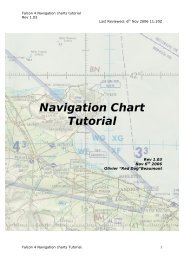
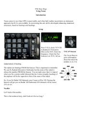
FS Station – www.fsstation.com3. Activate the VOR1 course tracking by clicking on the track buttonThe autopilot will now control the ailerons to keep the aircraft always on the 246 radial.The autopilot will follow the VOR radial you've selected on the HSI, but we still need to adjust it to climb. The climboptions are limited: you can either make it hold the present airspeed (that would be the best option, but it's not workingcorrectly) or control the pitch using the pitch button. Using the pitch button, find the pitch angle that will maintain theaircraft climbing at the proper climb speed... adjust it as necessary. That's how the autopilot works - simple, isn't it?!CruiseAt this time, you should have climbed to 20,000ft (FL200) using the speeds provided in the chart, leveled off andadjusted power to maintain 290 knots of true airspeed - the true airspeed gauge is available on the navigator panel (Nicon) only. For the first 212 miles of the flight, we'll continue to follow the LITTLE ROCK VOR's 246 radial. At about 100DME from the station, open the radio stack (tower icon) and change the NAV1/NAV2 radios to the BONHAM VOR (BYP -114.60) frequency - that will help on keeping the bearing needle always accurate. There is no need to change the courseon the HSI - we are flying to the same place, just using another station as reference. The bearing needle should remaincentered, but if there is a discrepancy you simply need to turn left or right to intercept and track the radial again.Now it's time to prepare for our first enroute turn. When you get close enough to the BONHAM VOR (let's say 10 miles),open the radio stack again and set the RANGER VOR (FUZ - 115.70) frequency on both NAV1 and NAV2 radios. Sincethe RANGER VOR is not in front of us, the bearing needle will go off center. There is no need to worry, I just want youto maintain the same heading and keep a close look on the HSI. Also, turn the course set knob (on the HSI) to 224 - it isthe only radial that passes both VOR stations and this is why we are going to fly it. At the appropriate time, turn left tointercept and track the new radial. We are now heading to the RANGER VOR with the BONHAM VOR right behind us!After 60 miles of flying this new radial, we'll need to do another turn and finally head to the airport. Again, 10 milesbefore reaching the RANGER VOR, set the ABILENE VOR (ABI - 113.70) frequency on both NAV1 and NAV2 radios.Turn the course set knob to 250 - it is the only radial that passes both VOR stations. The bearing needle will go off centeragain, you just need to keep the present heading and turn right when appropriate. Intercept and track the radial as soonas possible, but avoid exceeding 30 degrees of bank - if you missed it the first time, just make the appropriate correctionsto get on course.That's how we cruise using VOR's as navigation aids. It is certainly more difficult than setting and FMC and watching theautopilot do the job, but it's no rocket science. One you get enough experience, that will certainly be your favorite way offlying. We're done with cruising... let's proceed to the descent.Descent and approachAfter more than an hour in cruise level, it's finally time to prepare and start the descent. We'll now review the approach,configure the aircraft for descent and start approaching the airport. Since the C-130 cruises in a much lower level thanmost of the jetliners (FL350 vs. FL200), our descent should take only about 10 minutes. Let's start the preparation to getthis aircraft down to 5,000ft!A little break for the descent and approach briefing...Before actually starting the descend and approach, we need to brief the procedure in details - nothing can go wrong atthis stage. I want you to read this section very carefully!At about 45 miles from the ABILENE VOR (45 DME), move the throttles back to the flight idle position (flight idle, notground idle!) and remain at FL200. This should yield a zero torque configuration, resulting in an economic powerlessdescent. When the airspeed comes close to 210 knots, push forward on the yoke and start a 2000 feet per minutedescent; make the necessary adjustments to keep 210 knots then. I want you to keep a speed of about 210 knots and adescent rate of about 2000FPM - change attitude and throttle position as needed, but never let torque go negative. Thatattitude/speed should yield a near cruise speed descent and a good descent rate, allowing us to get down to 5,000ft (theinitial approach fix altitude) in a fairly low time. During the descent, I still want to you track the 250 radial to theABILENE VOR.FS Station – www.fsstation.comPage 14 of 20
FS Station – www.fsstation.comBefore we continue, please download (and print, if possible) the Dyess AFB ILS RNW 34 and ILS RNW 16 approachplates at AirNav.com. Approach plates provide essential information about the procedure, which must be strictly followed.If you are unfamiliar with them, please take some time to read our "How to interpret approach plates" tutorial.There are several limitations in both <strong>Flight</strong> <strong>Sim</strong>ulator and the <strong>Captain</strong> <strong>Sim</strong> C-130 that make this approach even morecomplicated. First of all, FS2004 does not support TACANs, which are a very common navigation aid in Air Force Bases.The DYESS TACAN could give us DME information, but since it is inoperative we have no way of knowing how far fromthe runway we are. Even if TACANs were operative, the C-130 doesn't have a working DME for the NAV2 radio - we'dhave to be switching frequencies in order to get a DME information from NAV2. Also, a real ATC could easily vector us tothe initial approach fix, but FS ATC is obviously not capable of that. Despite all these limitations, we are still able to do afairly realistic approach.Using the C-130E Takeoff and Landing Speeds file you have downloaded, determine the threshold and landingspeeds (for a flap 100% landing) based on your gross weight. Because of the weather conditions, I'll be landing onrunway 34. Don't worry you need to land on runway 16 - the approach is basically the same, but in the oppositedirection. Now look at the approach plate - notice that we're coming from the right side and that the approach begins 20miles before the threshold at 5,000 ft. We basically need to cross the airport, join the left traffic pattern, turn to final atabout 20 miles behind the runway and land using the ILS. In the meantime, we also need to reduce the speed, extendthe flaps/gear and configure the different systems of the aircraft. Let's now brief this approach in details.At this point, you should have already descended to 5,000ft and slowed down to 180 knots. Since we're joining the lefttraffic pattern, we'll continue to track the ABILENE VOR 250 radial until 5 miles past the station - that should provide aneat spacing for the downwind leg. After crossing the station and flying for 5 more miles, turn left to the opposite runwayheading (341) in order to enter the downwind leg. After the turn is completed, slow down to 150 knots. Still in thedownwind leg, I want you to set the ILS frequency on the NAV1 radio (I-DYS - 109.90) and turn the COURSE SET knob to161. We'll continue to fly in this heading (341deg), speed (150kts) and altitude (5,000ft) until the glideslope starts to goup. When the glideslope has gone all the way up, start another left turn to the base leg, reduce the speed to 140 knotsand command flaps 50%. In a short time, the localizer will become "alive", and you should make the last turn to finalapproach. When the final turn is completed, extend the landing gear and activate the auxiliary hydraulic pump. Finally,command flaps 100% and reduce the speed to about 130 knots "when landing is assured". Keep the localizer andglideslope centered at all times.FS Station – www.fsstation.comPage 15 of 20