

Storm Data and Unusual Weather Phenomena - CIG - Mesonet
Storm Data and Unusual Weather Phenomena - CIG - Mesonet
Storm Data and Unusual Weather Phenomena - CIG - Mesonet

You also want an ePaper? Increase the reach of your titles
YUMPU automatically turns print PDFs into web optimized ePapers that Google loves.
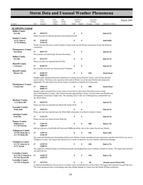
<strong>Storm</strong> <strong>Data</strong> <strong>and</strong> <strong>Unusual</strong> <strong>Weather</strong> <strong>Phenomena</strong>TimeLocal/PathLengthPathWidthNumber ofPersonsEstimatedDamageLocation Date St<strong>and</strong>ard (Miles) (Yards) Killed Injured Property Crops Character of <strong>Storm</strong>March 2005ALABAMA, CentralDallas CountyOrrville26 2023CST0 0Hail (0.75)Penny size hail covered the ground in <strong>and</strong> around Orrville.Sumter County6.5 E Cuba to 26 2315CST0 0Hail (0.88)15 NE Bellamy2335CSTNickel size hail fell across eastern Sumter County from near the Siloam community to near the Belmontcommunity.Montgomery CountySnowdoun27 0047CST0 0Hail (0.75)Pea to penny size hail briefly fell near Snowdoun.Dallas CountyOrrville27 0231CST0 0Hail (0.75)Penny size hail was reported near Orrville.Russell CountyCottonton27 0236CST0 0Hail (0.75)Pea to penny size hail was observed near Cottonton.Russell CountyPhenix City27 0240CST0600CST0 0 22KFlash FloodDoppler radar estimated three hour rainfall up to 4 inches across Russell County, with 24 hour amountsup to 6 inches. This heavy rain caused several roads in Phenix city to become flooded <strong>and</strong> temporarilyimpassable. Several roads were closed. Some evacuations occurred in low lying areas.Montgomery CountyCountywide27 0300CST0500CST0 0 38KFlash FloodDoppler radar estimated three to four inches of rain fell in a three hour time frame across a largepart of Montgomery County, with 24 hour amounts approaching 6 inches. Several roads were flooded <strong>and</strong>subsequently closed due to high water. The st<strong>and</strong>ing water in the city of Montgomery reached half wayup vehicle doors.Barbour County1.2 E Batesville 27 0422CST0 0Hail (0.75)Penny size hail was reported near Batesville along US 82.Lowndes CountyWhite Hall27 1041CST0 0Hail (0.75)Penny size hail was reported near the White Hall community in northern Lowndes County.Autauga CountyPrattville27 1121CST0 0Hail (0.75)Penny size hail was observed near Prattville.Elmore CountyMillbrook to27 1125CST0 0 18KHail (1.75)11.3 NE Eclectic1208CSTHail up to the size of golf balls fell from near Millbrook all the way to the county line at Lake Martin.Tallapoosa County8.9 SW Dadeville to 27 1159CST0 0 33KHail (3.00)11.1 NE Dadeville1234CSTThe supercell thunderstorm that produced hail across Elmore County strengthened <strong>and</strong> continued to produce hail all the way acrossTallapoosa County. The largest hail reported was 3 inches in diameter. Several vehicles suffered hail damage.Chambers County11.1 W Lafayette to 27 1225CST0 0 14KHail (1.75)6.3 E Stroud1258CSTThe supercell continued along its northeastward path <strong>and</strong> dropped hail across northern Chambers County. The largest hail reportedwas golf ball size.Lowndes County16.2 NW Ft Deposit to 27 1410CST0 0 11KHail (1.75)10.3 NE Hayneville1443CSTLowndes County9.2 NW Ft Deposit 27 1417CST0 0 4KThunderstorm Wind (G50)A supercell thunderstorm moved across Lowndes county <strong>and</strong> produced a swath of hail. The largest hail reported was golf ball size.The storm produced minor wind damage <strong>and</strong> some shingle damage to a home near the Mount Willing community.610


