Storm Data and Unusual Weather Phenomena - CIG - Mesonet
Storm Data and Unusual Weather Phenomena - CIG - Mesonet
Storm Data and Unusual Weather Phenomena - CIG - Mesonet
Create successful ePaper yourself
Turn your PDF publications into a flip-book with our unique Google optimized e-Paper software.
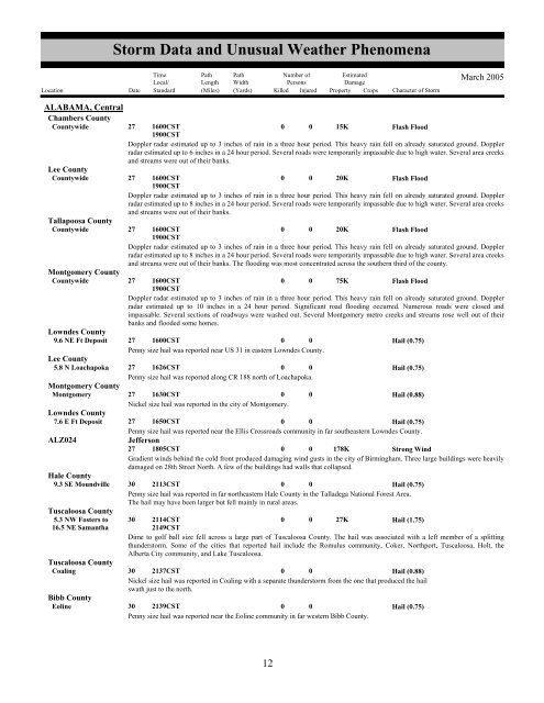
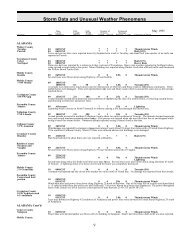
<strong>Storm</strong> <strong>Data</strong> <strong>and</strong> <strong>Unusual</strong> <strong>Weather</strong> <strong>Phenomena</strong>TimeLocal/PathLengthPathWidthNumber ofPersonsEstimatedDamageLocation Date St<strong>and</strong>ard (Miles) (Yards) Killed Injured Property Crops Character of <strong>Storm</strong>March 2005ALABAMA, CentralChambers CountyCountywide27 1600CST1900CST0 0 15KFlash FloodDoppler radar estimated up to 3 inches of rain in a three hour period. This heavy rain fell on already saturated ground. Dopplerradar estimated up to 6 inches in a 24 hour period. Several roads were temporarily impassable due to high water. Several area creeks<strong>and</strong> streams were out of their banks.Lee CountyCountywide27 1600CST1900CST0 0 20KFlash FloodDoppler radar estimated up to 3 inches of rain in a three hour period. This heavy rain fell on already saturated ground. Dopplerradar estimated up to 8 inches in a 24 hour period. Several roads were temporarily impassable due to high water. Several area creeks<strong>and</strong> streams were out of their banks.Tallapoosa CountyCountywide27 1600CST1900CST0 0 20KFlash FloodDoppler radar estimated up to 3 inches of rain in a three hour period. This heavy rain fell on already saturated ground. Dopplerradar estimated up to 8 inches in a 24 hour period. Several roads were temporarily impassable due to high water. Several area creeks<strong>and</strong> streams were out of their banks. The flooding was most concentrated across the southern third of the county.Montgomery CountyCountywide27 1600CST1900CST0 0 75KFlash FloodDoppler radar estimated up to 3 inches of rain in a three hour period. This heavy rain fell on already saturated ground. Dopplerradar estimated up to 10 inches in a 24 hour period. Significant road flooding occurred. Numerous roads were closed <strong>and</strong>impassable. Several sections of roadways were washed out. Several Montgomery metro creeks <strong>and</strong> streams rose well out of theirbanks <strong>and</strong> flooded some homes.Lowndes County9.6 NE Ft Deposit 27 1600CST0 0Hail (0.75)Penny size hail was reported near US 31 in eastern Lowndes County.Lee County5.8 N Loachapoka 27 1626CST0 0Hail (0.75)Penny size hail was reported along CR 188 north of Loachapoka.Montgomery CountyMontgomery27 1630CST0 0Hail (0.88)Nickel size hail was reported in the city of Montgomery.Lowndes County7.6 E Ft Deposit 27 1650CST0 0Hail (0.75)Penny size hail was reported near the Ellis Crossroads community in far southeastern Lowndes County.ALZ024Jefferson27 1805CST0 0 178KStrong WindGradient winds behind the cold front produced damaging wind gusts in the city of Birmingham. Three large buildings were heavilydamaged on 28th Street North. A few of the buildings had walls that collapsed.Hale County9.3 SE Moundville 30 2113CST0 0Hail (0.75)Penny size hail was reported in far northeastern Hale County in the Talladega National Forest Area.The hail may have been larger but fell mainly in rural areas.Tuscaloosa County5.3 NW Fosters to 30 2114CST0 0 27KHail (1.75)16.5 NE Samantha2149CSTDime to golf ball size fell across a large part of Tuscaloosa County. The hail was associated with a left member of a splittingthunderstorm. Some of the cities that reported hail include the Romulus community, Coker, Northport, Tuscaloosa, Holt, theAlberta City community, <strong>and</strong> Lake Tuscaloosa.Tuscaloosa CountyCoaling30 2137CST0 0Hail (0.88)Nickel size hail was reported in Coaling with a separate thunderstorm from the one that produced the hailswath just to the north.Bibb CountyEoline30 2139CST0 0Hail (0.75)Penny size hail was reported near the Eoline community in far western Bibb County.812


