Storm Data and Unusual Weather Phenomena - CIG - Mesonet
Storm Data and Unusual Weather Phenomena - CIG - Mesonet
Storm Data and Unusual Weather Phenomena - CIG - Mesonet
You also want an ePaper? Increase the reach of your titles
YUMPU automatically turns print PDFs into web optimized ePapers that Google loves.
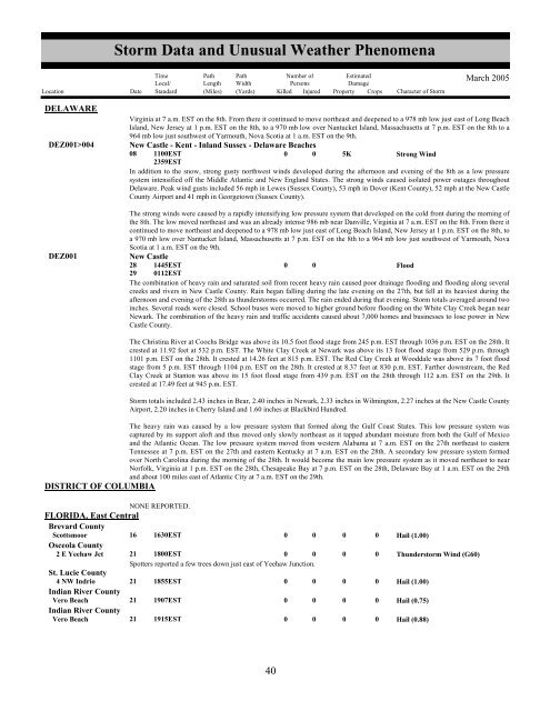
<strong>Storm</strong> <strong>Data</strong> <strong>and</strong> <strong>Unusual</strong> <strong>Weather</strong> <strong>Phenomena</strong>TimeLocal/PathLengthPathWidthNumber ofPersonsEstimatedDamageLocation Date St<strong>and</strong>ard (Miles) (Yards) Killed Injured Property Crops Character of <strong>Storm</strong>March 2005DELAWAREDEZ001>004DEZ001Virginia at 7 a.m. EST on the 8th. From there it continued to move northeast <strong>and</strong> deepened to a 978 mb low just east of Long BeachIsl<strong>and</strong>, New Jersey at 1 p.m. EST on the 8th, to a 970 mb low over Nantucket Isl<strong>and</strong>, Massachusetts at 7 p.m. EST on the 8th to a964 mb low just southwest of Yarmouth, Nova Scotia at 1 a.m. EST on the 9th.New Castle - Kent - Inl<strong>and</strong> Sussex - Delaware Beaches08 1100EST0 0 5KStrong Wind2359ESTIn addition to the snow, strong gusty northwest winds developed during the afternoon <strong>and</strong> evening of the 8th as a low pressuresystem intensified off the Middle Atlantic <strong>and</strong> New Engl<strong>and</strong> States. The strong winds caused isolated power outages throughoutDelaware. Peak wind gusts included 56 mph in Lewes (Sussex County), 53 mph in Dover (Kent County), 52 mph at the New CastleCounty Airport <strong>and</strong> 41 mph in Georgetown (Sussex County).The strong winds were caused by a rapidly intensifying low pressure system that developed on the cold front during the morning ofthe 8th. The low moved northeast <strong>and</strong> was an already intense 986 mb near Danville, Virginia at 7 a.m. EST on the 8th. From there itcontinued to move northeast <strong>and</strong> deepened to a 978 mb low just east of Long Beach Isl<strong>and</strong>, New Jersey at 1 p.m. EST on the 8th, toa 970 mb low over Nantucket Isl<strong>and</strong>, Massachusetts at 7 p.m. EST on the 8th to a 964 mb low just southwest of Yarmouth, NovaScotia at 1 a.m. EST on the 9th.New Castle28 1445EST0 0Flood29 0112ESTThe combination of heavy rain <strong>and</strong> saturated soil from recent heavy rain caused poor drainage flooding <strong>and</strong> flooding along severalcreeks <strong>and</strong> rivers in New Castle County. Rain began falling during the late evening on the 27th, but fell at its heaviest during theafternoon <strong>and</strong> evening of the 28th as thunderstorms occurred. The rain ended during that evening. <strong>Storm</strong> totals averaged around twoinches. Several roads were closed. School buses were moved to higher ground before flooding on the White Clay Creek began nearNewark. The combination of the heavy rain <strong>and</strong> traffic accidents caused about 7,000 homes <strong>and</strong> businesses to lose power in NewCastle County.The Christina River at Coochs Bridge was above its 10.5 foot flood stage from 245 p.m. EST through 1036 p.m. EST on the 28th. Itcrested at 11.92 feet at 532 p.m. EST. The White Clay Creek at Newark was above its 13 foot flood stage from 529 p.m. through1101 p.m. EST on the 28th. It crested at 14.26 feet at 815 p.m. EST. The Red Clay Creek at Wooddale was above its 7 foot floodstage from 5 p.m. EST through 1104 p.m. EST on the 28th. It crested at 8.37 feet at 830 p.m. EST. Farther downstream, the RedClay Creek at Stanton was above its 15 foot flood stage from 439 p.m. EST on the 28th through 112 a.m. EST on the 29th. Itcrested at 17.49 feet at 945 p.m. EST.<strong>Storm</strong> totals included 2.43 inches in Bear, 2.40 inches in Newark, 2.33 inches in Wilmington, 2.27 inches at the New Castle CountyAirport, 2.20 inches in Cherry Isl<strong>and</strong> <strong>and</strong> 1.60 inches at Blackbird Hundred.The heavy rain was caused by a low pressure system that formed along the Gulf Coast States. This low pressure system wascaptured by its support aloft <strong>and</strong> thus moved only slowly northeast as it tapped abundant moisture from both the Gulf of Mexico<strong>and</strong> the Atlantic Ocean. The low pressure system moved from western Alabama at 7 a.m. EST on the 27th northeast to easternTennessee at 7 p.m. EST on the 27th <strong>and</strong> eastern Kentucky at 7 a.m. EST on the 28th. A secondary low pressure system formedover North Carolina during the morning of the 28th. It would become the main low pressure system as it moved northeast to nearNorfolk, Virginia at 1 p.m. EST on the 28th, Chesapeake Bay at 7 p.m. EST on the 28th, Delaware Bay at 1 a.m. EST on the 29th<strong>and</strong> about 100 miles east of Atlantic City at 7 a.m. EST on the 29th.DISTRICT OF COLUMBIANONE REPORTED.FLORIDA, East CentralBrevard CountyScottsmoor 16 1630EST0 0 0 0Osceola County2 E Yeehaw Jct 21 1800EST0 0 0 0Spotters reported a few trees down just east of Yeehaw Junction.St. Lucie County4 NW Indrio 21 1855EST0 0 0 0Indian River CountyVero Beach 21 1907EST0 0 0 0Indian River CountyVero Beach 21 1915EST0 0 0 0Hail (1.00)Thunderstorm Wind (G60)Hail (1.00)Hail (0.75)Hail (0.88)3640


