

Storm Data and Unusual Weather Phenomena - CIG - Mesonet
Storm Data and Unusual Weather Phenomena - CIG - Mesonet
Storm Data and Unusual Weather Phenomena - CIG - Mesonet

Create successful ePaper yourself
Turn your PDF publications into a flip-book with our unique Google optimized e-Paper software.
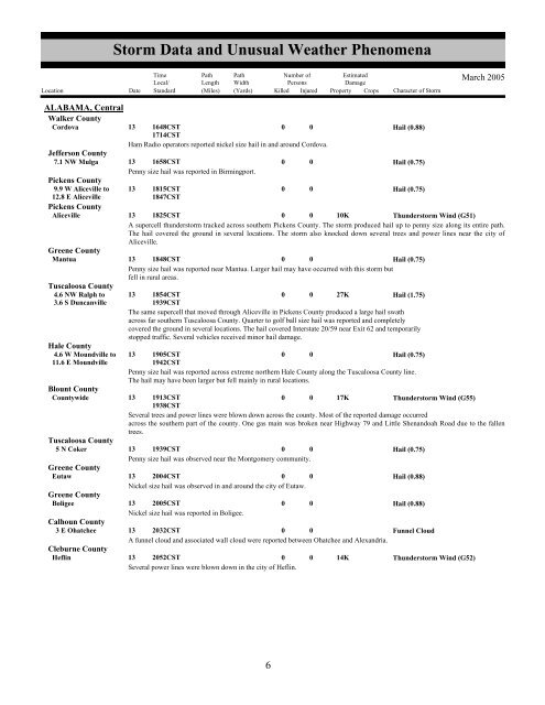
<strong>Storm</strong> <strong>Data</strong> <strong>and</strong> <strong>Unusual</strong> <strong>Weather</strong> <strong>Phenomena</strong>TimeLocal/PathLengthPathWidthNumber ofPersonsEstimatedDamageLocation Date St<strong>and</strong>ard (Miles) (Yards) Killed Injured Property Crops Character of <strong>Storm</strong>March 2005ALABAMA, CentralWalker CountyCordova13 1648CST1714CST0 0Hail (0.88)Ham Radio operators reported nickel size hail in <strong>and</strong> around Cordova.Jefferson County7.1 NW Mulga 13 1658CST0 0Hail (0.75)Penny size hail was reported in Birmingport.Pickens County9.9 W Aliceville to 13 1815CST0 0Hail (0.75)12.8 E Aliceville1847CSTPickens CountyAliceville13 1825CST0 0 10KThunderstorm Wind (G51)A supercell thunderstorm tracked across southern Pickens County. The storm produced hail up to penny size along its entire path.The hail covered the ground in several locations. The storm also knocked down several trees <strong>and</strong> power lines near the city ofAliceville.Greene CountyMantua13 1848CST0 0Hail (0.75)Penny size hail was reported near Mantua. Larger hail may have occurred with this storm butfell in rural areas.Tuscaloosa County4.6 NW Ralph to 13 1854CST0 0 27KHail (1.75)3.6 S Duncanville1939CSTThe same supercell that moved through Aliceville in Pickens County produced a large hail swathacross far southern Tuscaloosa County. Quarter to golf ball size hail was reported <strong>and</strong> completelycovered the ground in several locations. The hail covered Interstate 20/59 near Exit 62 <strong>and</strong> temporarilystopped traffic. Several vehicles received minor hail damage.Hale County4.6 W Moundville to 13 1905CST0 0Hail (0.75)11.6 E Moundville1942CSTPenny size hail was reported across extreme northern Hale County along the Tuscaloosa County line.The hail may have been larger but fell mainly in rural locations.Blount CountyCountywide13 1913CST1938CST0 0 17KThunderstorm Wind (G55)Several trees <strong>and</strong> power lines were blown down across the county. Most of the reported damage occurredacross the southern part of the county. One gas main was broken near Highway 79 <strong>and</strong> Little Shen<strong>and</strong>oah Road due to the fallentrees.Tuscaloosa County5 N Coker 13 1939CST0 0Hail (0.75)Penny size hail was observed near the Montgomery community.Greene CountyEutaw13 2004CST0 0Hail (0.88)Nickel size hail was observed in <strong>and</strong> around the city of Eutaw.Greene CountyBoligee13 2005CST0 0Hail (0.88)Nickel size hail was reported in Boligee.Calhoun County3 E Ohatchee 13 2032CST0 0Funnel CloudA funnel cloud <strong>and</strong> associated wall cloud were reported between Ohatchee <strong>and</strong> Alex<strong>and</strong>ria.Cleburne CountyHeflin13 2052CST0 0 14KThunderstorm Wind (G52)Several power lines were blown down in the city of Heflin.26


