

Storm Data and Unusual Weather Phenomena - CIG - Mesonet
Storm Data and Unusual Weather Phenomena - CIG - Mesonet
Storm Data and Unusual Weather Phenomena - CIG - Mesonet

Create successful ePaper yourself
Turn your PDF publications into a flip-book with our unique Google optimized e-Paper software.
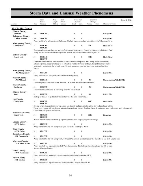
<strong>Storm</strong> <strong>Data</strong> <strong>and</strong> <strong>Unusual</strong> <strong>Weather</strong> <strong>Phenomena</strong>TimeLocal/PathLengthPathWidthNumber ofPersonsEstimatedDamageLocation Date St<strong>and</strong>ard (Miles) (Yards) Killed Injured Property Crops Character of <strong>Storm</strong>March 2005ALABAMA, CentralElmore CountyTallassee30 2359CST0 0Hail (0.75)Tallapoosa County1 SW Carrville 30 2359CST0 0Hail (0.75)Penny hail briefly fell in <strong>and</strong> near Tallassee. The hail was observed on both sides of the Tallapoosa River.Montgomery CountyCountywide31 0000CST0200CST0 0 11KFlash FloodDoppler radar estimated up to 4 inches of rain across Montgomery County in a short period of time. Thisheavy rain fell on already saturated ground. Several roads were closed to due high water.Elmore CountyCountywide31 0012CST0400CST0 0 15KFlash FloodDoppler Radar estimated up to 4 inches of rain in a three hour period. This heavy rain fell on alreadysaturated ground. Radar estimated up to 10 inches over the previous 24 hours. Several roadways weretemporarily impassable due to high water. Several residences received high water surrounding theirhomes.Montgomery County6 NE Montgomery 31 0015CST0 0Hail (0.75)Penny size hail was along US 231 in northern Montgomery.Macon County6 NE Milstead 31 0020CST0 0 7KThunderstorm Wind (G52)Trees <strong>and</strong> power lines were blown down on CR 36 near the Franklin community.Macon CountyHardaway31 0020CST0 0 5KThunderstorm Wind (G52)Trees were knocked down in Hardaway near Old Fedler Road.Elmore CountyKent31 0035CST0 0 6KHail (1.75)Hail up to the size of golf balls fell in <strong>and</strong> around the Kent community.Lee CountyCountywide31 0108CST0300CST0 0 80KFlash FloodSeveral severe thunderstorms moved across Lee County <strong>and</strong> each one brought a few inches of rain with it.These heavy rains fell on already saturated ground <strong>and</strong> caused flooding. Several roadways were underwater <strong>and</strong> subsequentlyclosed. One bridge was washed out.Tuscaloosa CountyCountywide31 0200CST0400CST0 0 65KLightningAt least three homes were struck by lightning <strong>and</strong> suffered varying degrees of damage.Greene County8 NW Boligee 31 0229CST0 0Hail (0.75)Penny size hail briefly fell along SR 39 just east of the Tombigbee River.Bibb County4 NW Eoline 31 0311CST0 0Hail (0.75)Tuscaloosa County5 SE Duncanville 31 0311CST0 0Hail (0.75)Penny size hail briefly fell along US 82 between Duncanville <strong>and</strong> Eoline near the Tuscaloosa <strong>and</strong> Bibb County line.Marengo County7 NW Sweet Water 31 0342CST0 0Hail (0.75)Penny size hail was reported in the Half Acre Community. The hail may have been larger but fell in ruralwestern Marengo County.Dallas County5 NW Marion Jct 31 0500CST0 0Hail (0.75)Penny size hail was observed in extreme northwest Dallas County near CR 5.Perry County5 SE Marion 31 0512CST0 0Hail (0.75)Penny size hail was reported near the Perry Municipal Airport along CR 45.1014


