Storm Data and Unusual Weather Phenomena - CIG - Mesonet
Storm Data and Unusual Weather Phenomena - CIG - Mesonet
Storm Data and Unusual Weather Phenomena - CIG - Mesonet
You also want an ePaper? Increase the reach of your titles
YUMPU automatically turns print PDFs into web optimized ePapers that Google loves.
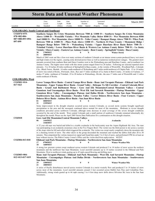
<strong>Storm</strong> <strong>Data</strong> <strong>and</strong> <strong>Unusual</strong> <strong>Weather</strong> <strong>Phenomena</strong>TimeLocal/PathLengthPathWidthNumber ofPersonsEstimatedDamageLocation Date St<strong>and</strong>ard (Miles) (Yards) Killed Injured Property Crops Character of <strong>Storm</strong>March 2005COLORADO, South Central <strong>and</strong> SoutheastCOZ074>075- Southern Sangre De Cristo Mountains Between 7500 & 11000 Ft - Southern Sangre De Cristo Mountains078>082-084- Above 11000 Ft - Westcliffe Vicinity / Wet Mountain Valley Below 8500 Ft - Wet Mountains Between 8500087>088-093>094- And 10000 Ft - Wet Mountains Above 10000 Ft - Teller County / Rampart Range Above 7500 Ft / Pikes Peak097-099Between 7500 & 11000 Ft - Pikes Peak Above 11000 Ft - Northern El Paso County / Monument Ridge /Rampart Range Below 7500 Ft - Walsenburg Vicinity / Upper Huerfano River Basin Below 7500 Ft -Trinidad Vicinity / Lower Huerfano River Basin & Western Las Animas County Below 7500 Ft - La JuntaVicinity / Otero County - Eastern Las Animas County - Bent County - Springfield Vicinity / Baca County30 1700MST0 0Winter <strong>Storm</strong>31 2000MSTMarch of 2005 went out like a lion over many sections of southern Colorado as an intense storm system produced heavy wet snow<strong>and</strong> high winds over the region...causing some downed power lines as well as numerous isolated power outages. The greatest snowamounts occurred from southern Bent <strong>and</strong> Otero Counties west to the Walsenburg area <strong>and</strong> Huerfano County...<strong>and</strong> in northern LasAnimas County. The higher snow totals with this storm system ranged from 8 to 20 inches. Following are selected reported snowamounts. 5 to 10 inches 20 miles northwest of Springfield in Baca county...in the vicinity of Westcliffe...Woodl<strong>and</strong> Park...ColoradoCity...Black Forest...Beulah...14 miles south-southeast of Walsenburg <strong>and</strong> 5 miles north-northwest of Chipita Park. 12 to 14 inchesof snow was noted at Rosita...Florissant...Kim...Rye <strong>and</strong> 17 miles southeast of La Junta in Bent County...16 inches in Cuchara...17inches 37 miles northeast of Trinidad...19 to 20 inches in Walsenburg...Divide...the area 17 miles east of Westcliffe <strong>and</strong> 11 milessouth-southeast of Rosita.COLORADO, WestCOZ001>014-017>023COZ010COZ004-013-018COZ003>004-012>013-017>019Lower Yampa River Basin - Central Yampa River Basin - Roan And Tavaputs Plateaus - Elkhead And ParkMountains - Upper Yampa River Basin - Gr<strong>and</strong> Valley - Debeque To Silt Corridor - Central Colorado RiverBasin - Gr<strong>and</strong> And Battlement Mesas - Gore And Elk Mountains/Central Mountain Valleys - CentralGunnison And Uncompahgre River Basin - West Elk And Sawatch Mountains - Flattop Mountains - UpperGunnison River Valley - Uncompahgre Plateau And Dallas Divide - Northwestern San Juan Mountains -Southwestern San Juan Mountains - Paradox Valley / Lower Dolores River Basin - Four Corners / UpperDolores River Basin - Animas River Basin - San Juan River Basin01 0000MST0 0Drought31 2359MSTSome improvement in the drought situation occurred across western Colorado, as several storm systems brought significantprecipitation to the area <strong>and</strong> the snowpack continued above normal for most of the mountains. Moderate to severe droughtconditions prevailed across northwest Colorado, although some decrease in areal coverage of the severe drought conditionsoccurred by the end of the month. West central Colorado <strong>and</strong> a small portion of southwest Colorado remained abnormally drythroughout the month. Please see the April 2005 <strong>Storm</strong> <strong>Data</strong> Publication for a continuation on this drought situation.Gore And Elk Mountains/Central Mountain Valleys06 1444MST1 0Avalanche1446MSTA 32 year old man was buried <strong>and</strong> killed in a sizable avalanche in the backcountry near the Aspen Highl<strong>and</strong>s Ski Area. The manwas participating in an avalanche awareness class in the Five Fingers Bowl. The victim was the third person to ski across a sectionof the slope when he fell <strong>and</strong> rolled which triggered the avalanche. The victim was swept nearly completely down the mountain sidein a churning torrent of snow. The other skiers in the group descended the mountain <strong>and</strong> reached the debris field after 20 to 30minutes. They pinpointed the victims transceiver signal <strong>and</strong> found him under 3 to 4 feet of snow, <strong>and</strong> performed CPR for at least anhour without success. The Pitkin County Corner's Office said the victim died from asphyxiation. M32OTElkhead And Park Mountains - Flattop Mountains - Northwestern San Juan Mountains17 0700MST0 0Winter <strong>Weather</strong>/Mix18 1600MSTA strong low pressure system swept southeast across western Colorado <strong>and</strong> produced 5 to 10 inches of snow across the northernmountains <strong>and</strong> the northwest San Juan Mountains. Local snowfall amounts up to 14 inches occurred in the Elkhead <strong>and</strong> ParkMountains. West to northwest winds gusting up to 45 mph caused blowing <strong>and</strong> drifting snow.Roan And Tavaputs Plateaus - Elkhead And Park Mountains - West Elk And Sawatch Mountains - FlattopMountains - Uncompahgre Plateau And Dallas Divide - Northwestern San Juan Mountains - SouthwesternSan Juan Mountains19 1500MST0 0Winter <strong>Weather</strong>/Mix21 1800MSTA series of Pacific disturbances moved across western Colorado in a moist westerly flow <strong>and</strong> produced 5 to 19 inches of snowacross most of the mountains. Local snowfall amounts around 2 feet occurred across Rabbit Ears Pass <strong>and</strong> Columbine Pass.Additionally, strong winds gusted up to 66 mph causing 3 to 4 foot deep snow drifts above Silverton Ski Area in the San JuanMountains.3034


