Storm Data and Unusual Weather Phenomena - CIG - Mesonet
Storm Data and Unusual Weather Phenomena - CIG - Mesonet
Storm Data and Unusual Weather Phenomena - CIG - Mesonet
You also want an ePaper? Increase the reach of your titles
YUMPU automatically turns print PDFs into web optimized ePapers that Google loves.
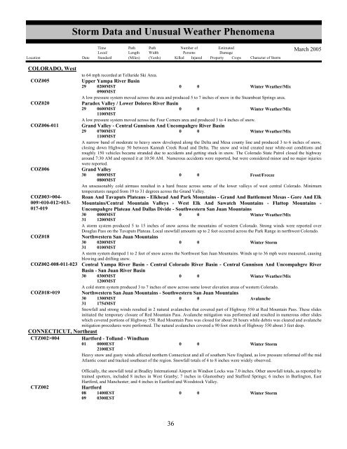
<strong>Storm</strong> <strong>Data</strong> <strong>and</strong> <strong>Unusual</strong> <strong>Weather</strong> <strong>Phenomena</strong>TimeLocal/PathLengthPathWidthNumber ofPersonsEstimatedDamageLocation Date St<strong>and</strong>ard (Miles) (Yards) Killed Injured Property Crops Character of <strong>Storm</strong>March 2005COLORADO, Westto 64 mph recorded at Telluride Ski Area.COZ005Upper Yampa River Basin29 0200MST0900MST0 0Winter <strong>Weather</strong>/MixA low pressure system moved across the area <strong>and</strong> produced 5 to 7 inches of snow in the Steamboat Springs area.COZ020Paradox Valley / Lower Dolores River Basin29 0600MST1100MST0 0Winter <strong>Weather</strong>/MixA low pressure system moved across the Four Corners area <strong>and</strong> produced 3 to 4 inches of snow.COZ006-011 Gr<strong>and</strong> Valley - Central Gunnison And Uncompahgre River Basin29 0700MST1100MST0 0Winter <strong>Weather</strong>/MixA narrow b<strong>and</strong> of moderate to heavy snow developed along the Delta <strong>and</strong> Mesa county line <strong>and</strong> produced 3 to 6 inches of snow,closing down Highway 50 between Kannah Creek Road <strong>and</strong> Delta. The snow <strong>and</strong> wind created near white-out conditions <strong>and</strong>roughly 150 vehicles became str<strong>and</strong>ed due to accidents <strong>and</strong> getting stuck in snow. The Colorado State Patrol closed the highwayaround 7:30 AM <strong>and</strong> opened it at 10:50 AM. Numerous accidents were reported, but were considered minor <strong>and</strong> no major injurieswere reported.COZ006Gr<strong>and</strong> Valley30 0000MST0800MST0 0Frost/FreezeAn unseasonably cold airmass resulted in a hard freeze across some of the lower valleys of west central Colorado. Minimumtemperatures ranged from 19 to 31 degrees across the Gr<strong>and</strong> Valley.COZ003>004-009>010-012>013-017-019Roan And Tavaputs Plateaus - Elkhead And Park Mountains - Gr<strong>and</strong> And Battlement Mesas - Gore And ElkMountains/Central Mountain Valleys - West Elk And Sawatch Mountains - Flattop Mountains -Uncompahgre Plateau And Dallas Divide - Southwestern San Juan Mountains30310000MST1200MST0 0Winter <strong>Weather</strong>/MixA storm system produced 5 to 15 inches of snow across the mountains of western Colorado. Strong winds were reported overDouglas Pass on the Tavaputs Plateau. Local snowfall amounts up to 2 feet occurred across the Park Range in northwest Colorado.COZ018Northwestern San Juan Mountains30310200MST0100MST0 0Winter <strong>Storm</strong>A storm system dumped 1 to 2 feet of snow across the Northwest San Juan Mountains. Winds up to 36 mph were measured, causingblowing <strong>and</strong> drifting snow.COZ002-008-011-023 Central Yampa River Basin - Central Colorado River Basin - Central Gunnison And Uncompahgre RiverBasin - San Juan River Basin30 0300MST1200MST0 0Winter <strong>Weather</strong>/MixA cold storm system produced 3 to 7 inches of snow across some lower elevation areas of western Colorado.COZ018>019 Northwestern San Juan Mountains - Southwestern San Juan Mountains30311300MST1754MST0 0AvalancheSnowfall <strong>and</strong> strong winds resulted in 2 natural avalanches that covered part of Highway 550 at Red Mountain Pass. These slidesinitiated the temporary closure of Red Mountain Pass. Avalanche mitigation was performed <strong>and</strong> resulted in numerous other slideswhich covered portions of Highway 550. Red Mountain Pass was closed for about 28 hours while debris was cleared <strong>and</strong> avalanchemitigation procedures were performed. The natural avalanches covered a 90 foot stretch of Highway 550 about 3 feet deep.CONNECTICUT, NortheastCTZ002>004 Hartford - Toll<strong>and</strong> - Windham01 0000EST2100EST0 0Winter <strong>Storm</strong>Heavy snow <strong>and</strong> gusty winds affected northern Connecticut <strong>and</strong> all of southern New Engl<strong>and</strong>, as low pressure reformed off the midAtlantic coast <strong>and</strong> tracked southeast of the region. Snowfall totals of 4 to 8 inches were widely observed.CTZ002Officially, the snowfall total at Bradley International Airport in Windsor Locks was 7.0 inches. Other snowfall totals, as reported bytrained spotters, included 8 inches in West Granby; 7 inches in Glastonbury <strong>and</strong> Stafford Springs; 6 inches in Burlington, EastHartford, <strong>and</strong> Manchester; <strong>and</strong> 4 inches in Eastford <strong>and</strong> Woodstock Valley.Hartford08091400EST0300EST00Winter <strong>Storm</strong>3236


