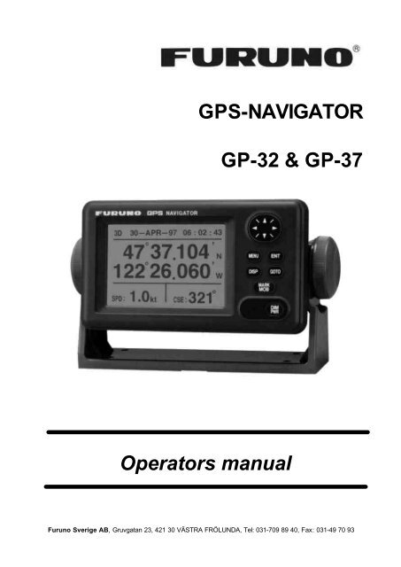
GPS-NAVIGATOR GP-32 & GP-37
GPS-NAVIGATOR GP-32 & GP-37
GPS-NAVIGATOR GP-32 & GP-37

Create successful ePaper yourself
Turn your PDF publications into a flip-book with our unique Google optimized e-Paper software.
iii
TABLE OF CONTENTSFOREWORD..................................viSYSTEM CONFIGURATION ..........viWHAT IS WAAS? .........................viiEQUIPMENT LISTS..................... viii1. OPERATIONAL OVERVIEW ......11.1 Controls........................................ 11.2 Turning On and Off Power........... 21.3 Adjusting Brilliance and Contrast. 21.4 Display Modes.............................. 31.5 Menu Overview ............................ 71.6 Simulation Display ....................... 82. PLOTTER DISPLAY OVERVIEW92.1 Choosing the Display Range ....... 92.2 Shifting the Cursor ....................... 92.3 Shifting the Display .................... 102.4 Centering Own Ship’s Position.. 102.5 Changing Track Plotting Interval,Stopping Plotting ........................ 102.6 Erasing Track..............................113. WAYPOINTS (MARKS) ............133.1 Entering Waypoints .................... 133.2 Entering the MOB Mark ............. 153.3 Displaying Waypoint Name........ 163.4 Operations on the Waypoint List163.5 Erasing Waypoints ..................... 173.6 Speed for Calculating Time-to-Go,Estimated Time of Arrival ........... 184. ROUTES ..................................194.1 Creating Routes ......................... 194.2 Editing Routes............................ 234.3 Erasing Routes........................... 255. DESTINATION .........................275.1 Setting Destination by Cursor.... 275.2 Setting Destination by Waypoint 275.3 Setting Route as Destination ..... 285.4 Setting User Waypoint asDestination ................................. 285.5 Canceling Destination................ 286.1 Arrival Alarm, Anchor WatchAlarm...........................................296.2 XTE (Cross Track Error) Alarm ..306.3 Speed Alarm ...............................316.4 WAAS/D<strong><strong>GP</strong>S</strong> Alarm....................316.5 Time Alarm..................................316.6 Trip Alarm....................................<strong>32</strong>6.7 Odometer Alarm .........................<strong>32</strong>6.8 Buzzer Type Selection................<strong>32</strong>7. OTHER FUNCTIONS...............3<strong>37</strong>.1 Calculating Range, Bearing,TTG and ETA..............................3<strong>37</strong>.2 WAAS Setup...............................347.3 D<strong><strong>GP</strong>S</strong> setup................................357.4 Bearing Reference......................<strong>37</strong>7.5 Magnetic Variation ......................387.6 Geodetic Chart System ..............387.7 Units of Measurement ................387.8 Position Display Format .............397.9 Time Difference (using local time),Time Format ...............................397.10 <strong><strong>GP</strong>S</strong> Setup..................................407.11 User Display Setup.....................417.12 Resetting Trip and OdometerDistances ....................................427.13 Uploading, DownloadingWaypoint, Route Data ................4<strong>37</strong>.14 Language....................................468. MAINTENANCE &TROUBLESHOOTING .............478.1 Maintenance...............................478.2 Displaying the Message Board ..478.3 Replacing the Fuse.....................488.4 Replacing the Battery.................488.5 Satellite Monitor Display.............498.6 Diagnostics.................................498.7 Clearing Data..............................506. ALARMS..................................29iv
9. INSTALLATION........................539.1 Installation of Display Unit..........539.2 Installation of Antenna Unit ........549.3 Wiring .........................................559.4 Initial Settings .............................56SPECIFICATIONS.....................SP-1OUTLINE DRAWINGSINTERCONNECTION DIAGRAMSINDEX...................................Index-1v
FOREWORDA Word to the Owner of the<strong>GP</strong>-<strong>37</strong>, <strong>GP</strong>-<strong>32</strong>Congratulations on your choice of the <strong>GP</strong>-<strong>37</strong>D<strong><strong>GP</strong>S</strong> Navigator, <strong>GP</strong>-<strong>32</strong> <strong><strong>GP</strong>S</strong> Navigator.For over 50 years FURUNO ElectricCompany has enjoyed an enviable reputationfor innovative and dependable marineelectronics equipment. This dedication toexcellence is furthered by our extensiveglobal network of agents and dealers.Your navigator is designed and constructed tomeet the rigorous demands of the marineenvironment. However, no machine canperform its intended function unless installed,operated and maintained properly. Pleasecarefully read and follow the recommendedprocedures for installation, operation, andmaintenance.We would appreciate hearing from you, theend-user, about whether we are achieving ourpurposes.Thank you for considering and purchasingFURUNO equipment.FeaturesThe <strong>GP</strong>-<strong>37</strong>/<strong>GP</strong>-<strong>32</strong> is a totally integrated <strong><strong>GP</strong>S</strong>receiver and video plotter, and mainlyconsists of a display unit and an antenna unit.The <strong>GP</strong>-<strong>37</strong> is additionally equipped with aD<strong><strong>GP</strong>S</strong> beacon receiver, built in the displayunit.The high sensitivity <strong><strong>GP</strong>S</strong> receiver tracks up to13 satellites (12 <strong><strong>GP</strong>S</strong>, 1 WAAS)simultaneously. An 8-state Kalman filterensures optimum accuracy in determinationof vessel position, course and speed.The main features of the <strong>GP</strong>-<strong>37</strong>/<strong>GP</strong>-<strong>32</strong> are• A D<strong><strong>GP</strong>S</strong> beacon receiver may beconnected to the <strong>GP</strong>-<strong>32</strong> to add D<strong><strong>GP</strong>S</strong>capability.• WAAS capability.• Storage for 999 waypoints and 50 routes• Alarms: Arrival/Anchor Watch, XTE(Cross-track Error), Trip, Odometer, Time,WAAS/D<strong><strong>GP</strong>S</strong>, and Speed.• Man overboard feature records position attime of man overboard and providescontinuous updates of range and bearingwhen navigating to the MOB position.• Bright 95 x 60 mm LCD with adjustablecontrast and brilliance.• Autopilot (option) may be connected, andsteering data output to the autopilot.• Unique Highway display provides a graphicpresentation of ship’s progress toward awaypoint.• User displays definable by operator.• Waypoint and route data can be uploadedfrom a PC and downloaded to a PC.vi
SYSTEM CONFIGURATIONNote: This equipment is intended for use on marine vessels. Do not use it in other applications.<strong>GP</strong>-<strong>37</strong> system configuration<strong>GP</strong>-<strong>32</strong> system configurationvi
WHAT IS WAAS?WAAS, available in North America, is a provider in the worldwide SBAS (Satellite BasedAugmentation System) navigation system. An SBAS provider furnishes <strong><strong>GP</strong>S</strong> signal correctionsto SBAS users, for even better position accuracy, typically better than three meters. Two moreSBAS providers are also currently under development, MSAS (Multi-Functional SatelliteAugmentation System) for Japan and EGNOS (Euro Geostationary Navigation Overlay Service)for Europe. All providers will be compatible with one another, thus providing “seamless” positionfixes to SBAS users.At the time of this software release, WAAS is still in the developmental phase. During thisdevelopmental phase, which may last several years, there is no guarantee of the accuracy,integrity, continuity, or availability of the WAAS signal. Therefore, FURUNO will accept noresponsibility for the use of the signal for other than the above stated purpose. It is the user’sresponsibility to exercise common prudence and navigational judgment when using the WAASsignal.Note: This manual uses “WAAS” when referring to any SBAS provider.vii
EQUIPMENT LISTSStandard supplyName Type Qty RemarksDisplayUnit<strong>GP</strong>-<strong>37</strong><strong>GP</strong>-<strong>32</strong>1With hanger, knobAntenna <strong>GP</strong>A-019 1 For <strong>GP</strong>-<strong>37</strong>, w/10 m cableUnit <strong>GP</strong>A-017 1 For <strong>GP</strong>-<strong>32</strong>, w/10 m cableInstallationMaterialsCP20-02310 1 set • Power/data cable (1 pc.)(Type: MJ-A7SPF0005-020, Code No.: 000-139-384)• Tapping screw (4 pcs.)(Type: 5X20, Code No.: 000-802-081)Spare Parts SP20-01001 1 set Fuse (2 pcs.)(Type: FGMB1A, Code No.: 000-114-805)Template C42-00201 1 Code No. 000-809-299, flush mounting templateHard Cover FP14-02801 1 Code No. 004-366-960Optional equipmentName Type Code No. Qty RemarksRight AngleAntenna BaseL-type AntennaBaseHandrailAntenna BaseMast MountingKitNO.13-QA330 000-803-239 1NO.13-QA310 000-803-240 1NO.13-RC5160 000-806-114 1CP20-01111 004-365-780 1 setCable Assy. MJ-A7SPF0009-020 000-145-612 1Flush MountingKit FFlush MountingKit SOP20-29 000-040-720 1 setOP20-17 000-041-405 1 setFor mounting the antennaunit, choose oneFor flush mounting thedisplay unit, choose oneviii
1. OPERATIONAL OVERVIEW1.1 ControlsHow to attach and remove the hard coverControl panelTo attach the hard cover, set it to the display unit at an angle.To remove the hard cover, do as follows:1
1. OPERATIONAL OVERVIEW1.2 Turning On and Off PowerTurning on the powerPress the [DIM/PWR] key. The unit beepsand then starts up with the last-used displaymode.Turning off the powerPress and hold down the [DIM/PWR] key untilthe screen goes blank (about three seconds).The time remaining until the power is turnedoff is counted down on the display.Note: The example screens shown in thismanual may not match the screens you seeon your display. The screen you see dependson your system configuration and equipmentsettings.1.3 Adjusting Brilliance andContrast1. Press the [DIM/PWR] key momentarily.The display shown below appears.Your equipment takes about 90 seconds tofind its position when turned on for the veryfirst time. Thereafter it typically takes about12 seconds.The equipment shows receiver statusindication at the top left-hand corner in mostdisplay modes. The table below shows theseindications and their meanings.Indication2D3DD2DD3DReceiver status indicationsMeaning2D <strong><strong>GP</strong>S</strong> position fix3D <strong><strong>GP</strong>S</strong> position fix2D D<strong><strong>GP</strong>S</strong> position fix3D D<strong><strong>GP</strong>S</strong> position fixW2D 2D WAAS position fixW3D 3D WAAS position fixDOP* 2D: HDOP larger than 43D: PDOP larger than 6SIM Simulation modeBrilliance and contrast adjustment window2. To adjust the brilliance, press ? or ? .Current setting is shown to the right of ? .Maximum setting is 8.3. To adjust the contrast, press ? or ? .Current setting is shown to the right of ? .Maximum setting is 63.4. Press the [ENT] key to finish.Note: If the last-used contrast setting is 36 orhigher, the equipment starts up with thatsetting. If the setting is 35 or lower, theequipment starts up with setting 36.* = DOP (Dilution of Precision) is the index ofposition accuracy and is the distributionpattern of satellites used in position fixing.Generally, the smaller the figure the better theposition accuracy.2
1. OPERATIONAL OVERVIEW1.4 Display ModesYour unit has five display modes: Plotter Display, Highway Display, Steering Display, Nav DataDisplay and User Display (digital data and speedometer). Press the [DISP] key to choose adisplay mode. Each time the key is pressed, the display mode changes in the sequence shownbelow.Display modes (default user displays)Note 1: The unit measures distances up to 9999 nm. Any distance greater than 9999 nm isshown as “*999”.Note 2: Position data can be shown in latitude and longitude or TDs (Loran C or Decca).3
1. OPERATIONAL OVERVIEWPlotter displayThe plotter display traces own ship’s track, and shows position, bearing to cursor, range tocursor, horizontal display range setting and receiver status.Highway displayPlotter displayThe highway display provides a 3-D view of own ship’s progress toward destination (waypoint).Nav data is also shown.4Highway display
1. OPERATIONAL OVERVIEWSteering displayThe steering display provides steering information such as ship’s speed, course, range, bearing,ETA and TTG.Nav data displaySteering displayThe nav data display shows receiver status, position in latitude and longitude (or TDs), courseover ground, speed over ground, date and time.Nav data display5
1. OPERATIONAL OVERVIEWUser displaysTwo user displays are available, digital and speedometer.Digital displayThe digital display shows digital navigation data. The user may choose what data to display inone to four cells. The choices of data are time, speed over ground, cross-track error, odometerdistance, position, course over ground, time-to-go to destination, trip distance, power sourcevoltage, range and bearing to waypoint, and estimated time of arrival at destination.Speedometer displayDigital display (default display)The speedometer display provides both digital and analog displays of speed over ground.Speedometer display6
1. OPERATIONAL OVERVIEW1.5 Menu OverviewMost operations of your unit are carried outthrough the menu. Below is a quickintroduction to how to choose a menu andchange menu settings. If you get lost inoperation, press the [MENU] key to return tothe MAIN MENU. For your reference, acomplete menu tree appears in the Appendix.1. Press the [MENU] key once or twice todisplay the menu.One press: Steering display, nav datadisplay and user display.Two presses: Plotter display, highwaydisplay.Track recording options5. Press ? or ? to choose option desired.6. Press the [ENT] key to register yourselection.7. Press the [MENU] key twice to close themenu.How to enter alphanumeric dataIn some instances it is necessary to enteralphanumeric data. The example belowshows how to enter a time difference of -6:30,to use local time instead of UTC time.1. Press the [MENU] key once or twice todisplay the menu.2. Choose SYS SETUP and then press the[ENT] key.Main menu2. Operate the cursor pad to choose a menuand then press the [ENT] key. Forexample, choose PLOTTER and thenpress the [ENT] key.SYSTEM SETUP menu3. Choose TIME DIFF.4. Press the [ENT] key. A cursorcircumscribes “+”. This cursor appearswhenever selected data can be changedwith the cursor pad.PLOTTER SETUP menu3. Use ? or ? to choose menu item. Forexample, choose TRACK REC.4. Press the [ENT] key. A window shows theoptions for the item selected. (Theillustration at the top of the next shows theoptions available for TRACK REC.)SYSTEM SETUP menu,TIME DIFF selected7
1. OPERATIONAL OVERVIEW5. Press ? to display “-“.6. Press ? to send the cursor to the nextdigit.7. Press ? or ? to display “0.”8. Press ? to send the cursor to the nextdigit.9. Press ? or ? to display “6.”10. Press ? to send the cursor to the nextdigit.11. Press ? or ? to display “3.”12. Press ? to send the cursor to the lastdigit.13. Press ? or ? to display “0.”14. Press the [ENT] key.15. Press the [MENU] key twice to finish.1.6 Simulation DisplayThe simulation display provides simulatedoperation of this unit. You may set the speedmanually and course manually orautomatically. All controls are operative - youmay enter marks, set destination, etc.1. Press the [MENU] key once or twice todisplay the menu.2. Choose SYS SETUP and then press the[ENT] key.3. Choose “SIMULATOR?” and then pressthe [ENT] key. (Note that position showndepends on language selected on theSYS SETUP menu. After changing thelanguage, the memory is cleared.)SIMULATOR menu4. The cursor is selecting MODE. Press the[ENT] key. A window shows the choicesON and OFF.5. Choose ON and then press the [ENT] key.6. Press the [ENT] key, use the cursor padto enter speed to use for the simulation,and then press the [ENT] key.7. Press the [ENT] key.8. Choose course (AUTO or MAN) and thenpress the [ENT] key. For manual entry ofcourse, press the [ENT] key, enter coursewith the cursor pad, and then press the[ENT] key. The AUTO course tracks acircular course.Note: Course must be AUTO to setsimulation destination.9. Press the [ENT] key, enter latitude withthe cursor pad, and then press the [ENT]key.10. Press the [ENT] key, enter longitude, andthen press the [ENT] key.11. Press the [MENU] key twice.12. Choose the PLOTTER display with the[DISP] key. SIM appears at the upperleft-hand corner when the simulatordisplay is active.Simulator display, auto course selected13. To turn off the simulator display, chooseOFF at step 5 in this procedure, press the[ENT] key and then press the [MENU] keytwice to finish.Note: If the power is turned off while thesimulator display is in use, the indicationSIMULATION MODE appears at the top ofthe screen at the next power up, in addition tothe indication SIM. SIMULATION MODEdisappears when any key is pressed,however the simulation mode continues.8
2. PLOTTER DISPLAY OVERVIEW2.1 Choosing the DisplayRangeYou may choose the display range on theplotter and highway displays. The horizontalrange in the plotter display is available among0.02 (40 yd), 0.05 (101 yd), 0.1 (202 yd), 0.2(405 yd), 0.5, 1, 2, 5, 10, 20, 40, 80, 160 and<strong>32</strong>0 nautical miles. (Nautical mile is thedefault unit of display range. Display rangemay also be shown in kilometers or miles.Ranges shorter than the 0.5 nm are alsoshown in yards or meters on the plotterdisplay.) The horizontal range in the highwaydisplay is available among 0.2, 0.4, 0.8, 1, 2,4, 8 and 16 nautical miles.1. Press the [MENU] key. The zoom, shipcentering window appears.3. Use ? (increase) or ? (decrease) tochoose range desired.4. Press the [ENT] key to close the zoom,ship centering window.2.2 Shifting the CursorUse the cursor pad to shift the cursor. Thecursor moves in the direction of the arrow ordiagonal pressed on the cursor pad.Cursor state and dataCursor state determines what data is shownon the display.Cursor turned onCursor position is displayed in latitude andlongitude or TDs (depending on menusetting) at the bottom of the plotter displaywhen the cursor is on. The range and bearingfrom own ship to the cursor appear at theleft-hand side of the display.Zoom, ship centering windowNote: “SHIP TO CENTER?” does notappear when the highway display mode isactive.2. ZOOM IN/OUT is selected. Press the[ENT] key to show the zoom window.Plotter display, cursor turned onZoom window9
2. PLOTTER DISPLAY OVERVIEWCursor turned offThe cursor is erased when there is no cursorpad operation for about six seconds. Ship’sposition, speed and course appear when thecursor is off.2.5 Changing Track PlottingInterval, Stopping PlottingTo trace the ship’s track, the ship’s position isstored into the memory at an interval ofdistance or according to display range. Fordistance, a shorter interval provides betterreconstruction of the track, but the storagetime of the track is reduced. When the trackmemory becomes full, the oldest track iserased to make room for the latest.1. Press the [MENU] key once or twice todisplay the menu.2. Choose PLOTTER.3. Press the [ENT] key.Plotter display, cursor turned off2.3 Shifting the DisplayThe display can be shifted on the plotterdisplay. Operate the cursor pad to place thecursor at an edge of the screen. The displayshifts in the direction opposite to cursor padoperation.PLOTTER SETUP menu4. The cursor is selecting TRACK REC.Press the [ENT] key to show the trackrecording method options.2.4 Centering Own Ship’sPositionWhen own ship tracks off the plotter display,the own ship mark is automatically returnedto the screen center. You can also return itmanually as follows:1. Press the [MENU] key.2. Choose “SHIP TO CENTER?”.3. Press the [ENT] key.Track recording method options5. Choose OFF, DISTANCE or AUTO andthen press the [ENT] key.OFF: Track is neither recorded norplotted. This setting is useful when you donot need to record track, for example,when returning to port.DISTANCE: Track is recorded andplotted at the distance interval set.AUTO: Plotting and recording intervalchanges with display range selected.10
2. PLOTTER DISPLAY OVERVIEW6. For AUTO or OFF, go to step 7. ForDISTANCE, enter the recording intervalas follows:a) Press the [ENT] key.b) Use ? or ? to choose digit to change.c) Use ? or ? to change value.d) Press the [ENT] key after setting therecording interval.7. Press the [MENU] key twice to finish.2.6 Erasing TrackAll track can be erased. Track cannot berestored once erased, therefore be absolutelysure you want to erase all track.1. Press the [MENU] key once or twice todisplay the menu.2. Choose ERASE and then press the [ENT]key to display the ERASE menu.ERASE menu3. Choose “TRACK?” and then press the[ENT] key. The message shown belowappears.Prompt for erasure of track4. Press ? to choose YES and then pressthe [ENT] key.5. Press the [MENU] key twice to finish.11
2. PLOTTER DISPLAY OVERVIEW(This page intentionally left blank.)12
3. WAYPOINTS (MARKS)3.1 Entering WaypointsIn navigation terminology a waypoint is aparticular location on a voyage, whether it bea starting, intermediate or destinationwaypoint. Your unit can store 999 waypoints.Waypoints can be entered on the plotterdisplay three ways: at cursor position, at ownship’s position, and from the waypoint list.c) Press ? to move the cursor one placeand then press ? or ? to display B.d) Press ? to move the cursor one placeand then press ? or ? to display E.e) Press the [ENT] key. The followingwindow appears.Entering a waypoint with the cursor1. Use the cursor pad to place the cursor onthe location desired for a waypoint.2. Press the [ENT] key. The followingwindow appears.Waypoint name entry window3. The cursor is on the second line of thedisplay. This is where you may enterwaypoint name, which may consist of sixalphanumeric characters. The numbershown is the youngest empty waypointnumber. If you would rather have the unitregister the waypoint under that number,and you do not need to change markshape or enter a comment, press the[ENT] key twice to register the waypointand finish. To enter KOBE as thewaypoint name, for example, do thefollowing:a) Press ? or ? to display K.b) Press ? to move the cursor one placeand then press ? or ? to display O.Waypoint attribute edit window4. This window is where you can choosemark shape, enter a comment, and logthe waypoint to a route (LOG RTE?). (Ifyou do not need to change mark shape orenter a comment, choose “Exit?” and thenpress the [ENT] key to finish. “LOG RTE?”is discussed in chapter 4.)a) Use the cursor pad to place the cursorunder “MARK.”b) Press the [ENT] key.c) Use ? or ? to choose mark desired.Mark selection sequence13
3. WAYPOINTS (MARKS)d) Press the [ENT] key. The cursor isselecting date/time, the defaultcomment. Press the [ENT] key.e) Enter a comment (max. 16alphanumeric characters) with thecursor pad and then press the [ENT]key. To create a space, choose the“blank” character. To remove allcharacters which follow the cursor,choose the underline.f) The cursor is on “Exit?.” Press the[ENT] key to finish.Entering a waypoint at own shipposition1. Press the [MARK/MOB] key momentarilyon any display. The following windowappears.5. To change mark shape, place the cursorunder “MARK.” Press the [ENT] key, use? or ? to choose mark desired, and thenpress the [ENT] key again.6. The cursor is selecting date/time. Tochange the date/time to your owncomment, press the [ENT] key, enter acomment with the cursor pad, and thenpress the [ENT] key again.7. Place the cursor on “Exit?.” Press the[ENT] key to finish.Entering a waypoint from the waypointlist1. Press the [MENU] key once or twice todisplay the menu.2. Choose WAYPOINTS.3. Press the [ENT] key to show the waypointlist options. Choose LIST. (NEARESTdisplays waypoints from nearest tofurthest; however, waypoints cannot beentered from this display.)Waypoint attribute edit window2. If you want to register the waypoint underthe number shown, and you do not needto change mark shape or enter acomment, press the [ENT] key to finish.3. To change name, choose NAME, pressthe [ENT] key, enter name with the cursorpad, and then press the [ENT] key. Thedisplay below appears.Create, rename, quit options4. Create is selected; press the [ENT] key.Waypoint list options4. Press the [ENT] key. The WPTS/MARKSlist appears.WPTS/MARKS listCURSOR: Cursor position whendestination is set with cursor.MOB: Man overboard position.START: Starting point when destinationis selected.14
3. WAYPOINTS (MARKS)5. The cursor is selecting “NEW?”; press the[ENT] key.3.2 Entering the MOB MarkThe MOB mark denotes man overboardposition. Only one MOB mark may be entered.Each time the MOB mark is entered theprevious MOB mark and its position data arewritten over.1. Press the [MARK/MOB] key on anydisplay until the following display appears.Waypoint name entry window6. Enter name (if desired) with the cursorpad and then press the [ENT] key.Waypoint attribute edit window7. The cursor is selecting latitude. Press the[ENT] key. Enter latitude with the cursorpad and then press the [ENT] key.8. Press the [ENT] key, enter longitude insimilar fashion as you did with latitude andthen press the [ENT] key.Note: To enter position by TDs, seeparagraph 7.7.9. To change mark shape, choose the markcurrently shown and then press the [ENT]key. Use ? or ? to choose mark desiredand then press the [ENT] key.10. To change date and time to the commentof your choice, press the [ENT] key, entercomment with the cursor pad, and thenpress the [ENT] key again.11. Place the cursor on “Exit?.” Press the[ENT] key.12. Press the [MENU] key twice to finish.MOB window2. To set MOB position as destination, press? to choose YES and then press the[ENT] key. Then, the plotter display marksMOB position as shown in the illustrationbelow.Note: Selecting “NO” saves the positionas a waypoint.Plotter display when MOBis set as destination15
3. WAYPOINTS (MARKS)3.3 Displaying WaypointNameYou may display waypoint name as follows:1. Press the [MENU] key once or twice todisplay the menu.2. Choose PLOTTER and then press the[ENT] key.3. Choose WPT NAME and then press the[ENT] key to show the waypoint namedisplay options.Waypoint name display options4. Choose DSP GOTO, DSP RTE or DSPALL as appropriate and then press the[ENT] key.DSP GOTO: Displays only the GOTOwaypoint name.DSP RTE: Displays all waypoint nameswhen a route is set as destination.DSP ALL: Displays all waypoint names.5. Press the [MENU] key twice to finish.3.4 Operations on theWaypoint ListEditing waypointsWaypoint position, waypoint name, markshape and comment can be edited from theWPTS/MARKS List.1. Press the [MENU] key once or twice todisplay the menu.2. Choose WAYPOINTS and then press the[ENT] key.3. Choose LIST or NEAREST and thenpress the [ENT] key.4. Choose waypoint to edit and then pressthe [ENT] key.Note: CURSOR, MOB and START areautomatically updated according todestination setting or MOB setting.Therefore, editing these items has nomeaning.5. Choose NAME and then press the [ENT]key.6. Change name with the cursor pad andthen press the [ENT] key. You are thenasked if you want to create or rename thewaypoint, or quit (escape) the display.Waypoint edit options7. Choose objective desired and then pressthe [ENT] key.8. Change position, mark shape, commentas desired.9. Choose “Exit?” and then press the [ENT]key.10. Press the [MENU] key twice to finish.16
3. WAYPOINTS (MARKS)Showing nearest waypoints bydistance, TTG and ETA1. Press the [MENU] key once or twice toopen the menu.2. Choose WAYPOINTS and then press the[ENT] key.3. Choose NEAREST and then press the[ENT] key. The display should looksomething like the one shown below,listing waypoints in order of distance fromown vessel, from closest to furthest.3.5 Erasing Waypoints1. Press the [MENU] key once or twice todisplay the menu.2. Choose ERASE and then press the [ENT]key.ERASE menu3. The cursor is selecting“WAYPOINTS/MARKS?”. Press the [ENT]key.WPTS/MARKS list (NEAREST) by distance4. To display ETA and TTG for eachwaypoint, press ? .WPTS/MARKS (NEAREST) list by TTG to ETA5. To return to the waypoint list by distance,press ? .6. Press the [MENU] key twice to close themenu.ERASE WPTS/MARKS display4. Choose the waypoint you want to erase.Note: You cannot erase CURSOR, MOBor START. To erase all waypoints, chooseALL.5. Press the [ENT] key. A screen showingposition and other particulars of thewaypoint selected appears.Waypoint data6. Press ? to choose “ERASE?” and thenpress the [ENT] key.7. Press the [MENU] key twice to finish.17
3. WAYPOINTS (MARKS)3.6 Speed for CalculatingTime-to-Go, EstimatedTime of ArrivalTo calculate time-to-go and estimated time ofarrival, enter your speed as below.1. Press the [MENU] key once or twice toopen the menu.2. Choose PLOTTER and then press the[ENT] key.3. ChooseTTG/ETA and then press the[ENT] key.4. Choose AUTO for automatic speed input(<strong><strong>GP</strong>S</strong> calculated speed), or MAN formanual input.5. Press the [ENT] key.6. For automatic speed input, go to step 7.For manual speed input, press the [ENT]key, enter speed with the cursor pad andthen press the [ENT] key.7. Press the [MENU] key twice to finish.18
4. ROUTESIn many cases a trip from one place toanother involves several course changes,requiring a series of waypoints which younavigate to, one after another. The sequenceof waypoints leading to the ultimatedestination is called a route. Your unit canautomatically advance to the next waypointon a route, so you do not have to change thedestination waypoint repeatedly.Creating a route with the cursorThis is probably the easiest method by whichto create a route.1. Use the cursor pad to place the cursor onposition desired. (Cursor position isshown at the bottom of the screen.)2. Press the [ENT] key. The followingwindow appears.4.1 Creating RoutesYou can store up to 50 routes (numbered 01to 50) and one LOG route, which is used totemporarily store a route. A route may beconstructed four ways: by the cursor, bywaypoints entered from the waypoint list, bywaypoints entered from route menu, and bystoring current position automatically ormanually.A route may contain 30 waypoints. When 30waypoints have been saved, a messageinforms you that you can no longer savewaypoints to the route. Press the [ENT] keyto erase the message and save the route,under the name of the first and last waypointnumbers used in the route.Note: Be sure to record all important routesin a separate log. This unit is not a fail-saferecord keeping device.Waypoint name entry windowThe cursor is on the second line of thedisplay. This is where you may enterwaypoint name. The number shown is theyoungest empty waypoint number. If youwant to register the waypoint under thatnumber, and you do not need to changemark shape or enter a comment, pressthe [ENT] key to register the waypoint,and then go to step 5.3. If desired, change the waypoint name.Press the [ENT] key.Sample routeWaypoint attribute edit window19
4. ROUTES4. If necessary, change waypoint, position,mark shape, and comment (date andtime).5. Choose “LOG RTE?” and then press the[ENT] key.6. Repeat steps 1 through 5 to complete theroute.7. When you have entered all the waypointpositions desired, press the [MENU] keytwice, choose ROUTES and then pressthe [ENT] key.ROUTES list4. “NEW?” is selected; press the [ENT] key.The screen shown below appears.ROUTES menu8. “LOG” shows the first and last waypointsentered for the log route you are currentlycreating. Choose LOG and then press the[ENT] key.Route processing options9. “MOVE?” is selected; press the [ENT] key.The route is moved from “LOG” and isregistered under the next sequential routenumber. (To edit the route before saving it,choose ”EDIT?”. For how to edit a route,see paragraph 4.2.)Screen for entering route by waypoint5. Choose location (01, etc.) and then pressthe [ENT] key. Use ? or ? to displaywaypoint name. (In the example, KOBE.)6. Press the [ENT] key.7. Repeat steps 5 and 6 until you haveentered all waypoints desired.Note: If you enter a waypoint which hasnot been registered, your screen will showa message which looks something like theone below. Press ? to choose YES andthen press the [ENT] key to create a newwaypoint; choose NO to return to theroute entry screen.Creating a route from the route menuThe procedure which follows describes howto create a route from two preregisteredwaypoints, KOBE and OSAKA.1. Press the [MENU] key once or twice todisplay the menu.2. Choose ROUTES.3. Press the [ENT] key.New waypoint creation screenWhen you choose YES, the followingscreen appears. Edit the waypoint asnecessary, choose “Exit?” and then pressthe [ENT] key.20
4. ROUTES4. Choose a waypoint and then press the[ENT] key. Your screen should looksomething like the one below.Waypoint attribute edit window8. “CMNT” shows the name of the route: thenames of the first and last waypoints inthe route. If you want to change the name,press ? to choose CMNT, press the[ENT] key, enter route name with thecursor pad and then press the [ENT] key.9. Choose “Exit?” at the top of the screen.10. Press the [ENT] key to register the route,under the next sequential route number.Then, the ROUTES list shows the nameof the first and last waypoints used, nextto route number.Waypoint attribute edit window5. Choose “LOG RTE?” and then press the[ENT] key.6. Repeat steps 4 and 5 to complete theroute.7. Press the [MENU] key once.8. Choose ROUTES and then press the[ENT] key. Your screen should now looksomething like the one shown below.ROUTES list11. Press the [MENU] key twice to finish.Creating a route from the waypoint list1. Press the [MENU] key once or twice todisplay the menu.2. Choose WAYPOINTS and then press the[ENT] key.3. Choose LIST or NEAREST and thenpress the [ENT] key.ROUTES list9. Choose LOG and then press the [ENT]key.Route processing options10. “MOVE?” is selected; press the [ENT]key. The route is moved from LOG andassigned the next sequential routenumber.11. Press the [MENU] key twice to finish.WPTS/MARKS (list)21
4. ROUTESCreating a track-based routeThere are two methods by which you cancreate a track-based route: manual input oftrack points using the [MARK/MOB] key andautomatic input of track points from theROUTES menu. A track-based route is usefulfor retracing your track.Creating a track-based route manuallyThis method creates a route by storingposition each time the [MARK/MOB] key ispressed.1. Press the [MARK/MOB] key momentarily.Waypoint attribute edit window2. Change name, comment and mark shapeif desired. Choose “LOG RTE?” and thenpress the [ENT] key.3. Repeat steps 1 and 2 when you changecourse.4. When you have entered all the waypointpositions desired, press the [MENU] keytwice, choose ROUTES and then pressthe [ENT] key.5. Choose LOG and then press the [ENT]key.Route processing options6. “MOVE?” is selected; press the [ENT] key.The route is moved from “LOG” and isregistered under the next sequential routenumber.7. Press the [MENU] key twice to finish.Creating a track-based route automaticallyThis method creates a route by automaticallystoring position at intervals of time ordistance.1. Press the [MENU] key once or twice toopen the menu.2. Choose ROUTES and then press the[ENT] key.3. Choose INTERVAL and then press the[ENT] key.4. Choose TIME or DISTANCE (the methodby which position will be stored) asappropriate and press the [ENT] key.5. Press the [ENT] key. Use the cursor padto set time or distance value and thenpress the [ENT] key.6. Choose VOYAGE ROUTE and then pressthe [ENT] key.ROUTES menuVoyage start options7. Choose START and then press the [ENT]key.22
4. ROUTES8. Press the [MENU] key twice to finish.The current position is saved under thenext sequential waypoint number, thedisplay shows “***SAVED!” (*** =waypoint number) and a beep sounds.Thereafter waypoints are saved at theinterval of time or distance set.When 30 waypoints have been saved, amessage informs you that you can nolonger save waypoints to the route. Pressthe [ENT] key to erase the message. Theroute is automatically saved to “LOG” inthe ROUTES menu, under the name ofthe first and last waypoint numbers used.Then, open the ROUTES menu and go tostep 13.5. Place the cursor on the waypoint toreplace.6. Press the [ENT] key to show the route editoptions.Route edit options7. “CHANGE?” is selected; press the [ENT]key.You can manually stop saving waypointsand save the route by going to step 9.9. After the desired number of waypointshave been entered, press the [MENU] keyonce or twice to open the menu.10. Choose ROUTES and then press the[ENT] key.11. Choose VOYAGE ROUTE and then pressthe [ENT] key.12. Choose STOP and then press the [ENT]key.13. Choose LOG and then press the [ENT]key.14.“MOVE?” is selected; press the [ENT] key.The route is moved from “LOG” and isregistered under the next sequential routenumber.15. Press the [MENU] key twice to finish.Waypoint attribute edit screen8. NAME is selected. Press the [ENT] key.Use the cursor pad to enter waypointname.9. Press the [ENT] key.Note: If the name entered at step 8 doesnot exist, the window shown belowappears. Choose “CREATE?”,“RENAME?” or “Quit?” as appropriate andthen press the [ENT] key.4.2 Editing RoutesReplacing waypoints in a route1. Press the [MENU] key once or twice todisplay the menu.2. Choose ROUTES and then press the[ENT] key.3. Choose the route to edit.4. Press the [ENT] key.Waypoint name options10. Choose “Exit?.”11. Press the [ENT] key.12. Press the [MENU] key twice to finish.23
4. ROUTESPermanently deleting a waypoint froma route1. Press the [MENU] key once or twice todisplay the menu.2. Choose ROUTES and then press the[ENT] key.3. Choose the route desired.4. Press the [ENT] key.5. Choose the waypoint you want to delete.6. Press the [ENT] key.7. Choose “REMOVE?.”8. Press the [ENT] key.9. Press the [MENU] key twice to finish.Inserting a waypoint in a routeTo insert a waypoint in a route, do thefollowing:1. Press the [MENU] key once or twice todisplay the menu.2. Choose ROUTES and then press the[ENT] key.3. Choose the route desired.4. Press the [ENT] key.5. Choose the waypoint which will comeafter the waypoint to be inserted. In theillustration below, for example, if you wantto insert the waypoint between KOBE and001, choose 001.Route contents (Route-01)6. Press the [ENT] key.7. Choose “INSERT?.”8. Press the [ENT] key.9. Use the cursor pad to enter waypoint.10. Press the [ENT] key.11. Press the [MENU] key twice to finish.Temporarily deselecting a waypoint ina routeYou can temporarily deselect an unnecessarywaypoint from a route. Using the routecreated in the illustration at the top of the nextcolumn as an example, deselect the 2ndintermediate waypoint.Sample routeIf you reconstruct the route without the 2ndintermediate point it would look like theillustration below.Reconstruction of sample route above withoutthe 2 nd intermediate waypoint1. Press the [MENU] key once or twice todisplay the menu.2. Choose ROUTES and then press the[ENT] key.3. Choose route desired and then press the[ENT] key.4. Place the cursor on the waypoint to skip.5. Press the [ENT] key.6. Choose “SKIP?” and then press the [ENT]key. “X” appears to the left of the waypointskipped as shown in the illustration below.Route contents (Route-01)24
4. ROUTES7. Press the [MENU] key twice to finish.To restore a waypoint to a route, choose“SKPoFF ?”at step 6 in this procedure, pressthe [ENT] key and then press the [MENU] keytwice to finish.Changing route comment (name)You can change the comment (name) for aroute as below. Up to 16 alphanumericcharacters may be used.1. Press the [MENU] key or twice to displaythe menu.2. Choose ROUTES and then press the[ENT] key.3. Choose route number and then press the[ENT] key.4. Choose CMNT and then press the [ENT]key.5. Enter comment with the cursor pad andthen press the [ENT] key.6. Press the [MENU] key twice to finish.4.3 Erasing Routes1. Press the [MENU] key or twice to displaythe menu.2. Choose ERASE and then press the [ENT]key.3. Choose “ROUTES?” and then press the[ENT] key.4. Choose the route you want delete. If youwant to delete all routes, choose “ALL?.”5. Press the [ENT] key. You are asked if youare sure to delete the route(s).Erase route options6. Choose YES and then press the [ENT]key.7. Press the [MENU] key twice to finish.25
4. ROUTES(This page intentionally left blank.)26
5. DESTINATIONDestination can be set four ways: by cursor,by waypoint, by route, and by MOB position.Previous destination is cancelled whenever adestination is newly set.A dashed line connects own ship and thedestination, which is marked with “CURSOR”and an “X,” as shown in the illustration below.5.1 Setting Destination byCursor1. Press the [GOTO] key to display theGOTO options window.GOTO options2. Choose “CURSOR?.”3. Press the [ENT] key. The plotter displayappears, with “?” shown to the right of thecursor.Destination set by cursor5.2 Setting Destination byWaypoint1. Press the [GOTO] key.2. Choose “WPT-LIST?” or “WPT-NEAR?”.3. Press the [ENT] key. The SELECT GOTOWPT list appears.Cursor appearancewhen setting destination by cursor4. Use the cursor pad to place the cursor onthe location desired for destination.5. Press the [ENT] key.SELECT GOTO WPT screens4. Choose a waypoint.5. Press the [ENT] key.Own ship’s position becomes the startingpoint and a dashed line runs between it andthe waypoint selected, which is shown inreverse video.27
5. DESTINATION5.3 Setting Route asDestination1. Press the [GOTO] key.2. Choose “ROUTE?”.3. Press the [ENT] key.5.4 Setting User Waypoint asDestinationYou may place a desired waypoint in theGOTO options window and use it to setdestination.Choosing user waypoint1. Press the [GOTO] key.2. Choose “SETUP?” and then press the[ENT] key.GOTO ROUTE list4. Choose a route.5. Press the [ENT] key. The followingoptions window appears.Route following direction options6. Choose “FORWARD?” or “REVERSE?”,the order in which to traverse the routewaypoints, and then press the [ENT] key.SELECT USER WPT list3. Choose waypoint desired and then pressthe [ENT] key. The GOTO windowappears, showing the waypoint selectedas below.Meaning of forward and reverseCurrent position becomes the starting point. Adashed line runs between the starting pointand all route waypoints. Next destinationwaypoint is shown in reverse video.The destination waypoint is automaticallyswitched when the boat enters the arrivalalarm range or the boat passes an imaginaryperpendicular line passing through the centerof the destination waypoint. For how to setthe arrival alarm, see paragraph 6.1.GOTO options4. Choose user waypoint and then press the[ENT] key.A dashed line connects own ship and thewaypoint selected, which is shown in reversevideo.5.5 Canceling DestinationYou can cancel destination as follows:1. Press the [GOTO] key.2. Choose “OFF?”.3. Press the [ENT] key.28
6. ALARMSThere are eight alarm conditions whichgenerate both audio and visual alarms:Arrival alarm, Anchor watch alarm, XTE(Cross-Track Error) alarm, Speed alarm,WAAS/D<strong><strong>GP</strong>S</strong> alarm, Time alarm, Trip alarmand Odometer alarm.When an alarm setting is violated, the buzzersounds and the name of the offending alarmand the alarm icon appear on the display.You can silence the buzzer and remove thealarm name indication by pressing any key.The alarm icon remains on the screen untilthe reason for the alarm is cleared.In some instances, multiple alarms may havebeen violated. You can see which alarm(s) issounding by displaying the message board.The keying sequence is [MENU] (once ortwice), MESSAGE, [ENT]. The messageboard is discussed in paragraph 8.2“Displaying the Message Board.”To disable an alarm, choose OFF as itsoption, press the [ENT] key and then pressthe [MENU] key twice.6.1 Arrival Alarm, AnchorWatch AlarmYou may activate the arrival alarm or theanchor watch alarm; they cannot be activatedtogether.Arrival alarmThe arrival alarm informs you that own ship isapproaching a destination waypoint. The areathat defines an arrival zone is that of a circlewhich you approach from the outside of thecircle. The alarm will be released if own shipenters the circle.How the arrival alarm works1. Press the [MENU] key once or twice toopen the menu.2. Choose ALARMS.3. Press the [ENT] key to show the ALARMSmenu.ALARMS menuLocation of alarm message and alarm icon29
6. ALARMS4. Choose ARV/ANC and then press the[ENT] key.Arrival/anchor watch options5. Choose ARV and then press the [ENT]key.6. Press the [ENT] key. Enter the alarmrange (0.0-99.99 nm) with the cursor pad.7. Press the [ENT] key.8. Press the [MENU] key twice to finish.When own ship nears the GOTO waypoint bythe range set here, the buzzer sounds andthe message ARV ALARM! appears.6. Press the [ENT] key. Enter the alarmrange (0.01-99.99 nm) with the cursorpad.7. Press the [ENT] key.8. Press the [MENU] key twice to finish.When own ship drifts more than the range sethere, the buzzer sounds and the messageANC ALARM! and the alarm icon appear.6.2 XTE (Cross Track Error)AlarmThe XTE alarm warns you when own ship isoff its intended course.Anchor watch alarmThe anchor watch alarm sounds to warn youthat own ship is moving when it should be atrest.How the anchor watch alarm worksBefore setting the anchor watch alarm, setcurrent position as destination waypoint,referring to paragraph 5.2.1. Press the [MENU] key once or twice toopen the menu.2. Choose ALARMS.3. Press the [ENT] key.4. Choose ARV/ANC and then press the[ENT] key.5. Choose ANC and then press the [ENT]key.How the XTE alarm works1. Press the [MENU] key once or twice toopen the menu.2. Choose ALARMS.3. Press the [ENT] key.4. Choose XTE and then press the [ENT]key.5. Choose ON and then press the [ENT] key.6. Press the [ENT] key. Enter alarm range(0.0-99.99 nm) with the cursor pad.7. Press the [ENT] key.8. Press the [MENU] key twice to finish.When own ship strays from the intended trackby the range set here, the buzzer sounds andmessage XTE ALARM! and the alarm iconappear.30
6. ALARMS6.3 Speed AlarmThe speed alarm provides visual and auralalerts when the ship’s speed is higher (orlower) than the alarm range set.1. Press the [MENU] key once or twice toopen the menu.2. Choose ALARMS.3. Press the [ENT] key.4. Choose SPEED and then press the [ENT]key.5. Choose LOW or HIGH as appropriate andthen press the [ENT] key.LOW: Alarm sounds when speed is lowerthan speed set.HIGH: Alarm sounds when speed ishigher than speed set.6. Press the [ENT] key. Enter speed(0.0-999.9 kt) with the cursor pad.7. Press the [ENT] key.8. Press the [MENU] key twice to finish.When the speed alarm setting is violated, thebuzzer sounds and the message SPDALARM! and the alarm icon appear.6.4 WAAS/D<strong><strong>GP</strong>S</strong> AlarmThis alarm alerts you by aural and visualalarms when the WAAS/D<strong><strong>GP</strong>S</strong> signal is lost.Note that ON cannot be selected if “MODE” inthe WAAS/D<strong><strong>GP</strong>S</strong> menu is set to <strong><strong>GP</strong>S</strong>.1. Press the [MENU] key once or twice toopen the menu.2. Choose ALARMS.3. Press the [ENT] key.4. Choose WAAS/D<strong><strong>GP</strong>S</strong> and then press the[ENT] key.5. Choose ON.6. Press the [ENT] key.7. Press the [MENU] key twice to finish.When the D<strong><strong>GP</strong>S</strong>/WAAS signal is lost, thebuzzer sounds and a message (see tablebelow) and the alarm icon appear. Further,the default position is shown.WAAS/D<strong><strong>GP</strong>S</strong> mode and alarm messageMODE onWAAS/D<strong><strong>GP</strong>S</strong>menuWAASINT BEACON,EXT BEACONAUTO6.5 Time AlarmAlarm condition, alarmmessageAlarms released whenreceiver status changes fromW2D or W3D to 2D or 3D.“WAAS ERROR!” and thealarm icon appear when thisoccurs.Alarms released whenreceiver status changes fromD2D or D3D to 2D or 3D.“D<strong><strong>GP</strong>S</strong> ERROR!” and thealarm icon appear when thisoccurs.Alarms released whenreceiver status changes fromD2D, D3D, W2D or W3D to2D or 3D. “WAAS/D<strong><strong>GP</strong>S</strong>ERROR!” and the alarm iconappear when this occurs.The time alarm works like an alarm clock,releasing audio and visual alarms when thetime entered has come.1. Press the [MENU] key once or twice toopen the menu.2. Choose ALARMS.3. Press the [ENT] key.4. Choose TIME and then press the [ENT]key.5. Choose ON and then press the [ENT] key.6. Press the [ENT] key.7. Enter time desired with the cursor pad.8. Press the [ENT] key.9. Press the [MENU] key twice to finish.When the time entered has come, the buzzersounds and the message TIME ALARM! andthe alarm icon appear.31
6. ALARMS6.6 Trip AlarmThis alarm alerts you by aural and visualalarms when your boat has traveled adistance greater than the trip alarm distance.1. Press the [MENU] key once or twice toopen the menu.2. Choose ALARMS.3. Press the [ENT] key.4. Choose TRIP and then press the [ENT]key.5. Choose ON and then press the [ENT] key.6. Press the [ENT] key. Enter distancedesired (001-999 nm) with the cursor pad.7. Press the [ENT] key.8. Press the [MENU] key twice to finish.When the boat has traveled further than thepreset trip distance, the buzzer sounds andthe message TRIP ALARM! and the alarmicon appear.6.7 Odometer AlarmThis alarm alerts you by aural and visualalarms when your boat has traveled the totaldistance you set.6.8 Buzzer Type SelectionThe buzzer sounds whenever an alarmsetting is violated. You can choose the typeof buzzer to use as follows:1. Press the [MENU] key once or twice toopen the menu.2. Choose ALARMS.3. Press the [ENT] key.4. Choose BUZZER and then press the[ENT] key.Buzzer sound options5. Choose buzzer type desired and thenpress the [ENT] key.SHORT: Two short beepsLONG: Three long beepsCONSTANT: Continuous beeps6. Press the [MENU] key twice to finish.1. Press the [MENU] key once or twice toopen the menu.2. Choose ALARMS.3. Press the [ENT] key.4. Choose ODOMETER and then press the[ENT] key.5. Choose ON and then press the [ENT] key.6. Press the [ENT] key. Enter distancedesired (001-999 nm) with the cursor pad.7. Press the [ENT] key.8. Press the [MENU] key twice to finish.When the boat has traveled further than thepreset trip distance, the buzzer sounds andthe message ODOMETER ALARM! and thealarm icon appear.<strong>32</strong>
7. OTHER FUNCTIONS7.1 Calculating Range,Bearing, TTG and ETARange and bearing between twowaypoints1. Press the [MENU] key once or twice toopen the menu.2. Choose CALCULATE and then press the[ENT] key.10. Press the [ENT] key. Enter speed with thecursor pad and then press the [ENT] key.The illustration below shows what thedisplay might look like using waypointsKOBE and OSAKA as the FROM and TOwaypoints, respectively.CALCULATION menu3. The cursor is selecting MODE. Press the[ENT] key.Range and bearing calculation options4. Choose WAYPOINTS and then press the[ENT] key.5. Press the [ENT] key.6. Enter the FROM waypoint and then pressthe [ENT] key.7. Press the [ENT] key, enter the TOwaypoint and then press the [ENT] key.8. Press the [ENT] key to display the speedinput options.Speed input options9. Choose AUTO or MAN and then press the[ENT] key. AUTO uses ship’s averagespeed; MAN is for manual entry of speed.For AUTO, see the illustration after step10 for sample range and bearingcalculation. For MAN, go to step 10.Typical range and bearing calculationbetween two waypoints11. Press the [MENU] key twice to finish.Range, TTG and ETA between first andfinal waypoints of a routeYou can easily find the range, TTG and ETAbetween the first and final waypoints of aroute as follows:1. Press the [MENU] key once or twice toopen the menu.2. Choose CALCULATE and then press the[ENT] key.3. Press the [ENT] key.4. Choose ROUTE and then press the [ENT]key.5. Press the [ENT] key.6. Choose route number from the route listwith the cursor pad.7. Press the [ENT] key to open the speedinput options window.8. Choose AUTO or MAN. AUTO uses ship’saverage speed; MAN is for manual entryof speed.33
7. OTHER FUNCTIONS9. Press the [ENT] key. If you selectedAUTO no further operation is necessary.See the illustration below for a calculationexample. For MAN, press the [ENT] key,enter speed with the cursor pad and thenpress the [ENT] key.The illustration below shows what thedisplay might look like using Route-01 asan example.4. Choose appropriate mode referring to thedescriptions below. Press the [ENT] key.WAAS: Position fix by WAASAUTO: Position fix in priority order ofD<strong><strong>GP</strong>S</strong>, WAAS, and <strong><strong>GP</strong>S</strong>.5. Press the [ENT] key.6. WAAS SEARCH is selected; press the[ENT] key.WAAS search optionsTypical TTG, ETA, range calculation for route10. Press the [MENU] key twice to finish.7. Choose AUTO for automatic search orMANUAL for manual search and thenpress the [ENT] key. For MANUAL, pressthe [ENT] key, enter appropriate WAASsatellite number, referring to theillustration below and then press the[ENT] key.AUTO mode and GEO satellite(as of April 2002)7.2 WAAS Setup1. Press the [MENU] key once or twice toopen the menu.2. Choose WAAS/D<strong><strong>GP</strong>S</strong> and then press the[ENT] key.ProviderWAASEGNOSGEO Satellite LongitudePOR (134) 178°EAOR-W (122) 54°WAOR-E (120) 15.5°WIOR (131) 64.5°EWAAS/D<strong><strong>GP</strong>S</strong> SETUP menu3. The cursor is selecting MODE; press the[ENT] key.GEO satellite and coverage areaWAAS/D<strong><strong>GP</strong>S</strong> mode options34
7. OTHER FUNCTIONS8. The cursor is now selectingCORRECTIONS DATA SET; press the[ENT] key.CORRECTIONS DATA SET determineshow to use the WAAS signal, currently inthe test mode. Use the default setting(02) until the WAAS system becomesoperational, then change the setting to“00”.9. Press the [ENT] key.10. Press the [MENU] key twice to close themenu.7.3 D<strong><strong>GP</strong>S</strong> setup1. Press the [MENU] key once or twice toopen the menu.2. Choose WAAS/D<strong><strong>GP</strong>S</strong>.WAAS/D<strong><strong>GP</strong>S</strong> SETUP menuINT BEACON: Position fix by internalD<strong><strong>GP</strong>S</strong> beacon receiver (<strong>GP</strong>-<strong>37</strong> only,cannot be selected on <strong>GP</strong>-<strong>32</strong>)EXT BEACON: Position fix by externalD<strong><strong>GP</strong>S</strong> beacon receiver (<strong>GP</strong>-<strong>32</strong>)AUTO: Position fix by D<strong><strong>GP</strong>S</strong>, WAAS and<strong><strong>GP</strong>S</strong>, in order of availability.Note: When connecting FURUNOexternal D<strong><strong>GP</strong>S</strong> beacon receiver GR-80 tothe <strong>GP</strong>-<strong>32</strong>, turn the GR-80’s remotefunction on to set up the beacon receiverwith data set on the <strong>GP</strong>-<strong>32</strong>.5. D<strong><strong>GP</strong>S</strong> STATION is selected; press the[ENT] key.6. Choose D<strong><strong>GP</strong>S</strong> beacon station selectionmethod: AUTO, MANUAL or LIST.AUTO: Automatically searches for best offive nearest D<strong><strong>GP</strong>S</strong> beacon station. It firstsearches D<strong><strong>GP</strong>S</strong> beacon stations fromclosest to furthest. If unsuccessful itsearches stations by signal strength. Thisprocedure is repeated until a suitablestation is found.MANUAL: Manually enter D<strong><strong>GP</strong>S</strong> beaconstation specifications at RATE and FREQ,referring to a D<strong><strong>GP</strong>S</strong> beacon station list.LIST: Lists five of the closest D<strong><strong>GP</strong>S</strong>beacon stations, includinguser-programmed stations.7. Press the [ENT] key. If you selectedAUTO no further operation is required; goto step 8. If you selected MANUAL or LIST,do one of the following and then go tostep 8.MANUAL3. Press the [ENT] key to show the modeoptions window.4. Choose one of the following and thenpress the [ENT] key.a) The cursor is selecting RATE. Pressthe [ENT] key.b) Choose the transmission rate of theD<strong><strong>GP</strong>S</strong> beacon station to be used,among 50, 100 or 200 bps. Press the[ENT] key.c) The cursor is selecting FREQ. Pressthe [ENT] key.35
7. OTHER FUNCTIONSd) Use the cursor pad to enter thetransmission frequency of the D<strong><strong>GP</strong>S</strong>beacon station to be used and thenpress the [ENT] key.LISTa) The following display appears afterpressing the [ENT] key at step 6.D<strong><strong>GP</strong>S</strong> STATION (USER) list6. Choose “NEW?” and then press the [ENT]key.D<strong><strong>GP</strong>S</strong> beacon station listb) Use the cursor pad to choose stationdesired.c) Press the [ENT] key.8. Press the [MENU] key twice to finish.Programming D<strong><strong>GP</strong>S</strong> user channels(stations)The user may program 20 D<strong><strong>GP</strong>S</strong> beaconstations from which to use in D<strong><strong>GP</strong>S</strong> beaconstation selection. Whenever a new station isconstructed you can add it to the list.1. Press the [MENU] key twice to open themenu.2. Choose D<strong><strong>GP</strong>S</strong>/WAAS and then press the[ENT] key.3. Choose D<strong><strong>GP</strong>S</strong> STATION and then pressthe [ENT] key.4. Choose LIST and then press the [ENT]key.5. Choose USER and then press the [ENT]key.NEW USER CHANNEL (D<strong><strong>GP</strong>S</strong>) set up menu7. Press the [ENT] key, enter frequency ofthe station, and then press the [ENT] key.8. Press the [ENT] key, enter baud rate ofthe station, and then press the [ENT] key.9. Press the [ENT] key, enter latitude of thestation, and then press the [ENT] key.10 Press the [ENT] key, enter longitude ofthe station, and then press the [ENT] key.11. Choose “SAVE?” and then press the[ENT] key.12. Press the [MENU] key twice to finish.Editing D<strong><strong>GP</strong>S</strong> user channels1. Press the [MENU] key twice to open themenu.2. Choose WAAS/D<strong><strong>GP</strong>S</strong> and then press the[ENT] key.3. Choose D<strong><strong>GP</strong>S</strong> STATION and then pressthe [ENT] key.4. Choose LIST and then press the [ENT]key.5. Choose USER and then press the [ENT]key.36
7. OTHER FUNCTIONS6. Choose a station from the list and thenpress the [ENT] key. The display lookssomething like the one below.Screen for entering D<strong><strong>GP</strong>S</strong> station data7. Choose item, press the [ENT] key, editdata, and then press the [ENT] key.8. Choose “SAVE?” and then press the[ENT] key.9. Press the [MENU] key twice to finish.Erasing all user channels1. Press the [MENU] key twice to open themenu.2. Choose D<strong><strong>GP</strong>S</strong>/WAAS and then press the[ENT] key.3. Choose D<strong><strong>GP</strong>S</strong> STATION and then pressthe [ENT] key.4. Choose LIST and then press the [ENT]key.5. Choose USER and then press the [ENT]key.6. Choose “CLR?” and then press the [ENT]key. The following message appears.Erasing individual user channels1. Press the [MENU] key twice to open themenu.2. Choose D<strong><strong>GP</strong>S</strong>/WAAS and then press the[ENT] key.3. Choose D<strong><strong>GP</strong>S</strong> STATION and then pressthe [ENT] key.4. Choose LIST and then press the [ENT]key.5. Choose USER and then press the [ENT]key.6. Choose a channel from the list and thenpress the [ENT] key.7. Choose “ERASE?”.8. Choose YES and then press the [ENT]key.9. Press the [MENU] key twice to finish.7.4 Bearing ReferenceShip's course and bearing to a waypoint maybe displayed in true or magnetic bearing.Magnetic bearing is true bearing plus (orminus) earth’s magnetic deviation. Use thebearing reference in accordance with thecompass interfaced: magnetic for magneticcompass, true for gyrocompass. The defaultsetting displays magnetic bearings.1. Press the [MENU] key once or twice toopen the menu.2. Choose PLOTTER.3. Press the [ENT] key.4. Choose BRG. REF.5. Press the [ENT] key.D<strong><strong>GP</strong>S</strong> channel erase options7. Press ? to choose YES and then pressthe [ENT] key.8. Press the [MENU] key twice to finish.Bearing reference options6. Choose MAG or TRUE as appropriate.7. Press the [ENT] key.8. Press the [MENU] key twice to finish.<strong>37</strong>
7. OTHER FUNCTIONS7.5 Magnetic VariationThe location of the magnetic north pole isdifferent from the geographical north pole.This causes a difference between the trueand magnetic north direction. This differenceis called magnetic variation, and varies withrespect to the observation point on earth.Your unit is preprogrammed with all theearth's magnetic variation. However, you maywish to enter variation manually to refineaccuracy. Set “BRG REF” on the PLOTTERis set to “MAG” to use magnetic variation.1. Press the [MENU] key once or twice toopen the menu.2. Choose PLOTTER and then press the[ENT] key.3. Choose MAG. VAR.4. Press the [ENT] key.5. Choose AUTO or MAN as appropriateand then press the [ENT] key. Forautomatic magnetic variation, currentmagnetic variation appears to the right ofAUTO.6. If you selected AUTO, no furtheroperation is necessary; go to step 7. ForMAN, press the [ENT] key and entermagnetic variation as follows:a) If necessary, change coordinate fromeast to west or vice versa by pressing? or ? .b) Press ? to shift cursor, use ? or ? toset value, referring to a nautical chart.c) Press the [ENT] key.7. Press the [MENU] key twice to finish.7.6 Geodetic Chart SystemYour unit is preprogrammed to recognizemost of the major chart systems of the world.Although the WGS-84 system, the <strong><strong>GP</strong>S</strong>standard, is now widely used other categoriesof charts still exist. Choose the chart systemused, not the area where your boat is sailing.The default chart system is WGS-84.1. Press the [MENU] key once or twice toopen the menu.2. Choose SYS SETUP and then press the[ENT] key.SYSTEM SETUP menu3. Choose DATUM and then press the [ENT]key.4. Choose WGS84 (<strong><strong>GP</strong>S</strong> standard), WGS72or OTHER as appropriate and then pressthe [ENT] key.5. If you selected WGS84 or WGS72, go tostep 6. For OTHER, do the following:a) Press the [ENT] key.b) Use the cursor pad to enter chartnumber, referring to the geodetic chartlist on page AP-3.c) Press the [ENT] key.6. Press the [MENU] key twice to finish.7.7 Units of MeasurementDistance/speed can be displayed in nauticalmiles/knots, kilometers/kilometers per hour,or statute miles/miles per hour.1. Press the [MENU] key once or twice toopen the menu.2. Choose SYS SETUP and then press the[ENT] key.3. Choose UNITS.4. Press the [ENT] key.5. Choose combination desired; nm, kt; km,km/h; sm, mph.6. Press the [ENT] key.7. Press the [MENU] key twice to finish.38
7. OTHER FUNCTIONS7.8 Position Display FormatPosition may shown in latitude and longitudeor TDs (Loran C or Decca) as follows. Deccaand Loran C chain data is preprogrammed.1. Press the [MENU] key once or twice toopen the menu.2. Choose TD SETUP and then press the[ENT] key.d) If necessary enter TD offsets at ?TD1and ?TD2 to refine position accuracy.For Decca TD:a) Choose DECCA and then press the[ENT] key.b) Use the cursor pad to chooseappropriate Decca chain number andlane pair (R, Red, G, Green, P, Purple),referring to the Decca chain list onpage AP-5.c) Press the [ENT] key.d) If necessary enter TD offsets at ?TD1and ?TD2 to refine position accuracy.7. Press the [MENU] key twice to finish.TD SETUP menu3. The cursor is on the first line. Press the[ENT] key.Position display options4. Choose desired position format.XX.XXX’: Shows L/L position with noseconds.XX’XX.X’: Displays L/L position withseconds.LC TD: Loran C TDsDE TE: Decca TDs5. Press the [ENT] key. If you selected alatitude and longitude format, go to step 7.6. For Loran C or Decca, do one of thefollowing and then go to step 7.For Loran C TD:a) The cursor is on LORAN C. Press the[ENT] key.b) Use the cursor pad to chooseappropriate GRI code and secondarycodes, referring to the Loran C chainlist on page AP-4.c) Press the [ENT] key.7.9 Time Difference (usinglocal time), Time Format<strong><strong>GP</strong>S</strong> uses UTC time. If you would rather uselocal time, enter the time difference (range:-13:30 to +13:30) between it and UTC time.You may display the time in 12 or 24 hourformat.1. Press the [MENU] key once or twice toopen the menu.2. Choose SYS SETUP and then press the[ENT] key.3. Press ? to choose TIME DIFF and thenpress the [ENT] key.4. Press ? or ? to display “+” or “-“ asappropriate.5. Enter time difference with the cursor pad.6. Press the [ENT] key.7. The cursor is selecting TIME DISP. Pressthe [ENT] key.8. Choose 12 HOUR or 24 HOUR asappropriate and then press the [ENT] key.9. Press the [MENU] key twice to finish.39
7. OTHER FUNCTIONS7.10 <strong><strong>GP</strong>S</strong> SetupThe <strong><strong>GP</strong>S</strong> SETUP menu smoothes positionand course, averages speed, applies positionoffset, and deactivates unhealthy satellites.1. Press the [MENU] key once or twice toopen the menu.2. Choose <strong><strong>GP</strong>S</strong> SETUP and then press the[ENT] key.SMOOTH S/C (Smoothing speed/course)During position fixing, ship’s velocity (speedand course) is directly measured by receiving<strong><strong>GP</strong>S</strong> satellite signals. The raw velocity datamay changes randomly depending onreceiving conditions and other factors. Youcan reduce this random variation byincreasing the smoothing. Like with latitudeand longitude smoothing, the higher thespeed and course smoothing the moresmoothed the raw data. If the setting is toohigh, however, the response to speed andcourse change slows. The setting range isfrom 0 (no smoothing) to 9999 seconds.AVR. SPEED (Speed averaging)<strong><strong>GP</strong>S</strong> SETUP menu3. Choose item and then press the [ENT]key.4. Change setting with the cursor pad andthen press the [ENT] key.5. Press the [MENU] key twice to finish.<strong><strong>GP</strong>S</strong> SETUP menu descriptionSMOOTH POS (Smoothing position)When the DOP (Dilution of Precision, theindex for position-fixing accuracy) or receivingcondition is unfavorable, the <strong><strong>GP</strong>S</strong> fix maychange greatly, even if the vessel is dead inwater. This change can be reduced bysmoothing the raw <strong><strong>GP</strong>S</strong> fixes. The settingrange is from 0 (no smoothing) to 999seconds. The higher the setting the moresmoothed the raw data, however too high asetting slows response time to change inlatitude and longitude. This is especiallynoticeable at high ship’s speeds. “0” is thenormal setting; increase the setting if the<strong><strong>GP</strong>S</strong> fix changes greatly.Calculation of ETA and TTG, etc. is based onaverage ship's speed over a given period. Ifthe period is too long or too short, calculationerror will result. Change this setting ifcalculation error occurs. The default setting is60 seconds. The setting range is from 0 (noaveraging) to 9999 seconds.LAT/LON OFFSET (L/L position offset)You may apply an offset to latitude andlongitude position generated by the <strong><strong>GP</strong>S</strong>receiver, to increase position accuracy.DISABLE SVEvery <strong><strong>GP</strong>S</strong> satellite is broadcasting abnormalsatellite number(s) in its Almanac, whichcontains general orbital data about all <strong><strong>GP</strong>S</strong>satellites. Using this information, the <strong><strong>GP</strong>S</strong>receiver automatically eliminates anymalfunctioning satellite from the <strong><strong>GP</strong>S</strong> satelliteschedule. However, the Almanac sometimesmay not contain this information. You candisable an inoperative satellite manually.Enter satellite number in two digits and thenpress the [ENT] key. To restore a satelliteenter “00”.40
7. OTHER FUNCTIONSDISABLE GEOLike <strong><strong>GP</strong>S</strong> satellites, the <strong><strong>GP</strong>S</strong> receiverautomatically eliminates any malfunctioningWAAS satellite. To disable a WAAS satellitemanually, enter three-digit satellite numberwith the cursor pad and then press the [ENT]key. To restore a satellite, enter “000”.FIX MODEChooses position fixing method; 2D or 2/3D.2D requires three satellites in view of the<strong><strong>GP</strong>S</strong> receiver; 2/3D requires three or foursatellites in view of the <strong><strong>GP</strong>S</strong> receiver,whichever is available. When the 2D mode isselected, enter the antenna height above thewaterline, to obtain accurate position data.The default setting is 5 m.7.11 User Display SetupThe user displays, which appear when the[DISP] key is pressed several times, provideuser-customized digital data and aspeedometer.3. Choose 1 or 2 and then press the [ENT]key.User display type options4. Choose DIGITAL and then press the[ENT] key.5. The cursor is selecting the square at theright side of the screen. Press the [ENT]key.User display screen division options6. Choose the screen division desired, thatis, the number of data to display, and thenpress the [ENT] key. The display nowlooks something like the one shownbelow.Digital dataThe user may choose 1-4 items of navigationdata to display on the digital display.1. Press the [MENU] key once or twice toopen the menu.2. Choose USER DISP and then press the[ENT] key.USER DISPLAY menu,default digital display settings7. “A” is selected. Press the [ENT] key.USER DISPLAY menuDigital data options41
7. OTHER FUNCTIONS8. Use the cursor pad to choose datadesired and then press the [ENT] key.NONE: No displayODO: Odometer distanceTRIP: Trip distanceTIME: Time and datePOSN: PositionPOWER: Power source voltageSOG: Speed over groundCOG: Course over groundWPT: Rng and brg to waypointXTE: Cross-track errorTTG: Time to go (to destination)ETA: Estimated time of arrival(at destination)9. Control returns to the User display setup,with “B” selected. Depending on theselection made at step 5, set otherindications similar to how you did with “A”.10. Press the [MENU] key twice to finish.9. Enter scale interval: Use ? or ? tochoose location and ? or ? to entervalue. The setting range is 1 to 99.10. Press the [ENT] key.11. Press the [MENU] key twice to close themenu.7.12 Resetting Trip andOdometer Distances1. Press the [MENU] key once or twice toopen the menu.2. Choose ERASE and then press the [ENT]key.3. Choose “RESET TRIP?” (or “RESETODO?”) and then press the [ENT] key.One of following displays appears.Speedometer display1. Press the [MENU] key once or twice toopen the menu.2. Choose USER DISP and then press the[ENT] key.3. Choose 1 or 2 and then press the [ENT]key.4. Choose SPEEDOMETER and then pressthe [ENT] key.Reset trip meter, odometer options4. Press ? to choose YES and then pressthe [ENT] key to reset distance to zero.5. Press the [MENU] key twice to finish.42Speedometer menu5. The cursor is selecting START FROM.Press the [ENT] key.6. Enter starting speed: Use ? or ? toselect location and ? or ? to enter valueand switch from plus to minus and viceversa. The setting range is -99 to +99.7. Press the [ENT] key, and the cursor shiftsto INTERVAL.8. Press the [ENT] key.
7. OTHER FUNCTIONS7.13 Uploading, DownloadingWaypoint, Route DataWaypoint and route data may be downloadedto a PC or uploaded from a PC to your unit.WiringYour equipment provides a wiring diagramwhich shows how to connect to a PC using aDSUB 9-pin connector (EIA-574). You maydisplay it as follows.1. Press the [MENU] key once or twice toopen the menu.2. Choose I/O SETUP and then press the[ENT] key.3. Choose WIRING INFO and then press the[ENT] key to display the wiring diagram.Setting for communication software onPCBaud Rate: 4800 bpsCharacter Length: 8 bitStop Bit: 1 bitParity: NoneX Control: XON/OFFDownloading/Uploading between PCand <strong>GP</strong>-<strong>37</strong>/<strong>GP</strong>-<strong>32</strong>Waypoint data and route data can bedownloaded/uploaded between a personalcomputer and the <strong>GP</strong>-<strong>37</strong>/<strong>GP</strong>-<strong>32</strong>.Note 1: There are two kinds of data for routedata: route data and route comment data.Note 2: No position fix is available duringuploading or downloading.Downloading data to a PC1. Press the [MENU] key once or twice toopen the menu, choose I/O SETUP andthen press the [ENT] key.Wiring diagram, usingDSUB 9-pin connectorNote: A DSUB 25-pin (EIA-2<strong>32</strong>) may also beused to make the connection. In this case thewiring diagram is as follows.I/O SETUP menu2. Choose SAVE WPT/RTE → PC?.3. Press the [ENT] key.Wiring diagram, usingDSUB 25-pin connectorSAVE WP/RTE display4. Press the [ENT] key.43
7. OTHER FUNCTIONSSAVING START? prompt5. Set up the computer to receive data.6. Press ? to choose YES and then pressthe [ENT] key to download.LOADING START? prompt5. Set up the computer to output data.6. Press ? to choose YES and then pressthe [ENT] key to upload.Note: The waypoint and route data aredeleted when the [ENT] key is pressed.Message when data is being loaded7. When the loading is completed, thefollowing message appears.Downloading sequence7. Press any key to escape.Uploading data from a PCNote that all waypoint and route data storedin the <strong>GP</strong>-<strong>37</strong>/<strong>GP</strong>-<strong>32</strong> will be deleted when datais uploaded.1. Press the [MENU] key once or twice toopen the menu, choose I/O SETUP andthen press the [ENT] key.2. Choose LOAD WPT/RTE ← PC?.3. Press the [ENT] key.Message when data is loaded successfully8. Press any key to escape.Loading data from a YEOMANWaypoint data from a YEOMAN has thesame format as does the NMEA 0183 datasentence WPL.1. Press the [MENU] key twice, choose I/OSETUP and then press the [ENT] key.2. Choose LOAD WPT ← YEOMAN?.3. Press the [ENT] key.LOAD WP/RTE display4. Press the [ENT] key.LOAD YEOMAN WP display44
7. OTHER FUNCTIONS4. Press the [ENT] key.LOADING START? prompt5. Set up the YEOMAN to output data.6. Press ? to choose YES and then pressthe [ENT] key to load data.Message when waypoints are being loaded7. Data is loaded to empty location and thebuzzer sounds twice to signify successfulloading. If there is not enough memoryfree to store the waypoints, the messagebelow appears.7: Waypoint comment (2 byte for mark code+ 16 characters of comment.)1st byte of mark code: Fixed to '@'.2nd byte of mark code: Internal markcode + 'a' (0 x 61). See Note 1 on thenext page.Number of characters for comment isless than 16 (variable length). See Note 2on the next page.8: Flag making waypoint. Always set to “A”.“A”: Displayed”V”: Not displayed9: UTC (Always NULL)10: Day (Always NULL)11: Month (Always NULL)12: Year (Always NULL)Note 1: Internal mark code is 0 x 10 through0 x 18. 0 x 71 through 0 x 79 are alwaysplaced at 2nd byte of mark code.Note 2: Following characters can be used forcomments:Message when waypointscould not be loadedCharacters available for commentsRoute data formatWaypoint data formatWaypoint data format1: Waypoint latitude2: N/S3: Waypoint longitude4: E/W5: Waypoint name (Number of characters isfixed to 6 and space code is placed whenthe number of characters are less than6.)6: Waypoint color (This field is always keptNULL.)Route data format1: Number of sentences required for onecomplete route data (1 to 4). See Note.2: Number of sentences currently used (1 to4)3: Message mode (Always set to C).4: Route No. (01 to 51 (51 is LOG route, 2digits required)5 through 12: Waypoint name (Max. 8names, length of eachwaypoint name is fixed to 7byte)45
7. OTHER FUNCTIONS1st byte: Skip code '-' (Hyphen) = SkipON, Space code = Skip OFFAfter 2nd byte: Waypoint name (fixed to6 bytes)Note: A route can contain max. 30 waypointsand <strong>GP</strong>RTE sentence for one route data mayexceed 80 byte limitation. In this case, routedata is divided into several <strong>GP</strong>RTEsentences (Max. 4 sentences). This valueshows the number of sentences route datahas been divided.7.14 LanguageEnglish and other languages are available.1. Press the [MENU] key.2. Choose SYS SETUP and then press the[ENT] key.3. The cursor is selecting LANGUAGE.Press the [ENT] key.Route comment data formatRoute comment data format1: Route No. (01 to 51, 2 digits required)2: Route comment (Max. 16 characters,variable length)The same characters of the comment forwaypoint comment can be used.Language options4. Choose language desired and then pressthe [ENT] key.5. Press the [MENU] key once to return tothe main menu.6. Clear all backup data as shown inparagraph 8.7.End of sentenceEnd of sentence format46
8. MAINTENANCE &TROUBLESHOOTING8.1 MaintenanceRegular maintenance is important to maintainperformance. Check the following pointsmonthly to help maintain performance.• Check that connectors on the rear panelare firmly tightened and free of rust.• Check that the ground system is free ofrust and the ground wire is tightly fastened.• Check that battery terminals are clean andfree of rust.• Check the antenna for damage. Replace ifdamaged.• Dust and dirt on the keyboard and displayscreen may be removed with a soft cloth.Do not use chemical cleaners to clean theequipment; they may remove paint andmarkings. Use special care when cleaningthe LCD – it is easily scratched.8.2 Displaying the MessageBoardThe message board displays error messagesand alerts. You can display it as follows:1. Press the [MENU] key once or twice toopen the menu.2. Choose MESSAGES.3. Press the [ENT] key.MESSAGE board4. Press the [MENU] key twice to quit themessage board.MessagesMessageMessages and their meaningsANCHOR WATCH!ARRIVAL ALARM!BACKUP ERRORDATA/BATTERY ALARM!NO D<strong><strong>GP</strong>S</strong> SIGNAL!<strong><strong>GP</strong>S</strong> NO FIX!HIGH VOLTAGE!LOW VOLTAGE!ODOMETER ALARM!RAM ERROR!ROM ERROR!RTC ERROR!SPEED ALARM!TIME ALARM!TRIP ALARM!NO WAAS SIGNAL!NO WAAS/D<strong><strong>GP</strong>S</strong>SIGNAL!XTE ALARM!Meaning, RemedyAnchor watch alarmviolated.Arrival alarm violated.RAM data corrupted.Try to clear backupdata. See para. 8.4.Voltage of battery indisplay unit is low.Request replacement.WAAS/D<strong><strong>GP</strong>S</strong> alarmviolated. *1No <strong><strong>GP</strong>S</strong> signal. Checkantenna cable.Power source voltagetoo high.Power source voltagetoo low.Odometer distancealarm violated.Request service.Request service.Request service.Speed alarm violated.Time alarm violated.Trip distance alarmviolated.WAAS/D<strong><strong>GP</strong>S</strong> alarmviolated. *2WAAS/D<strong><strong>GP</strong>S</strong> alarmviolated. *3XTE alarm violated.*1 = WAAS/D<strong><strong>GP</strong>S</strong> mode: INT/EXT BEACON*2 = WAAS/D<strong><strong>GP</strong>S</strong> mode: WAAS*3 = WAAS/D<strong><strong>GP</strong>S</strong> mode: AUTO47
8. MAINTENANCE & TROUBLESHOOTING8.3 Replacing the FuseThe fuses (1A) in the power cable (+/- lines)protects the equipment from overcurrent,reverse polarity of the power source andequipment fault. If the fuse blows, find thecause before replacing the fuse. If the fuseblows again after replacement, requestservice.1. Turn on the power and then press the[MENU] key once or twice to open themenu.2 Choose SYS SETUP and then press the[ENT] key.8.4 Replacing the BatteryA lithium battery (type: CR2354-1F2, codeno.: 000-142-305) on the circuit board insidethe display unit preserves data when thepower is turned off. The life of the battery is3-5 years. When its voltage is low, themessage shown below appears and data istransferred from the RAM to the flashmemory.SYSTEM SETUP menu3. Choose “EXCHANGE BATTERY?” andthen press the [ENT] key. The displayshows the following message.Exchange battery prompt4. Press ? to choose YES and then pressthe [ENT] key. The following displayappears.Low battery voltage warningWhen this message appears, all openwindows are closed, no alarm will begenerated and no key input other than the[ENT] key is accepted. Press the [ENT] key toback up data and then turn off the power.Contact your dealer to request replacementof the battery. Below is the procedure forreplacing the battery.Battery exchangeconfirmation window5. Press any key to automatically turn off theunit.6. Replace the battery.Note 1: When it is expected that theequipment will not be used for a long time,execute the above procedure before turningthe power off, to prevent loss of data.Note 2: Data is copied from the flash memoryto the RAM at the next power up.48
8. MAINTENANCE & TROUBLESHOOTING8.5 Satellite Monitor DisplayThe satellite monitor display showsinformation about <strong><strong>GP</strong>S</strong> and GEO satellites.1. Press the [MENU] key once or twice toopen the menu.2. Choose SATELLITE.3. Press the [ENT] key.Number, bearing and elevation angle ofall <strong><strong>GP</strong>S</strong> and GEO satellites (if applicable)in view of your receiver appear. Satellitesbeing used in fixing position are displayedin reverse video; satellites not being usedare shown in normal video.8.6 DiagnosticsThe diagnostic test checks ROM, RAM, dataport, beacon receiver, battery, RTC, keyboardand LCD for proper operation.1. Press the [MENU] key once or twice toopen the menu.2. Choose SYS SETUP and then press the[ENT] key.3. Choose “TEST?” and then press the[ENT] key. You are asked if you are readyto start the test.TEST START? prompt4. Press ? to choose YES and then pressthe [ENT] key to start the test.5. The equipment tests ROM, RAM, dataport, beacon receiver, internal battery andRTC. The results are individuallydisplayed as OK or NG (No Good).Satellite monitor display4. Press the [MENU] key twice to quit theSATELLITE display.TEST results (<strong>GP</strong>-<strong>37</strong>)Note 1: BEACON test result shown asNONE when no beacon receiver isconnected to the <strong>GP</strong>-<strong>32</strong>.Note 2: DATA2 requires a specialconnector to check. “- -” appears as theresult when no connector is connected.Note 3: No program number shown forBEACON in case of the <strong>GP</strong>-<strong>32</strong>.Note 4: CNT shows the number of timesthe test has been executed consecutively.49
8. MAINTENANCE & TROUBLESHOOTING6. After the equipment has displayed the testresults, a beep sounds and the messagePUSH KEY appears at the top right-handcorner.7. Press each key one by one. The name ofthe key pressed momentarily appears atthe top right-hand corner if the key isfunctioning properly.Note: If no key is pressed within approx.five seconds, the equipment automaticallyproceeds to step 8.8. The equipment displays the followingmessage to inform you that it is now goingto check the LCD:LCD check9. The LCD is checked, and then the test isrepeated. To stop the test, turn off thepower.8.7 Clearing DataYou may clear <strong><strong>GP</strong>S</strong> data, menu settings andall backup data to start afresh.1. Press the [MENU] key once or twice toopen the menu.2. Choose ERASE and then press the [ENT]key.3. Choose <strong><strong>GP</strong>S</strong> DATA, MENU SETTINGS,or ALL BACKUP DATA as appropriateand then press the [ENT] key. One of thefollowing messages appears.Prompt for erasure of <strong><strong>GP</strong>S</strong> data, menusettings, backup data4. Press ? to choose YES and then pressthe [ENT] key. The following displayappears.Prompt for restarting5. Hit any key to erase item selected. Abeep sounds while the selected item isbeing erased.Note 1: If you were using the simulationmode when data is cleared, the message“Start Simulation – Are You Sure? appears.Choose YES and press the [ENT] key to startthe simulation mode, or press the [ENT] keyto start normal operation50
8. MAINTENANCE & TROUBLESHOOTINGNote 2: When the memory is cleared the default position is restored as below.Language and default position, unit and time differenceLanguage Default Position Unit Time DifferenceEnglish 38°N, 123°W nm, kt 0:00German 54°N, 10°E nm, kt 0:00French 44°51E, 0°40W km, km/h 0:00Spanish 40°26E, 3°40W nm, kt +2:00Italian 42°N, 12°E nm, kt +1:00Portuguese 22°44S, 43°10W nm, kt -3:00Dutch 38°N, 123°W nm, kt 0:00Vietnamese 12°15N, 109°13E nm, kt +7:00Japanese 34°44N, 135°21E nm, kt +9:0051
8. MAINTENANCE & TROUBLESHOOTING(This page intentionally left blank.)52
9. INSTALLATION9.1 Installation of Display UnitMounting considerationsThe display unit can be installed on a desktop,on the overhead, or in a panel (optional flushmounting kit required). Refer to the outlinedrawings at the end of this manual forinstallation instructions. When choosing amounting location, keep in mind the followingpoints:• Locate the unit away from exhaust pipesand vents.• The mounting location should be wellventilated.• Mount the unit where shock and vibrationare minimal.• Locate the unit away from equipment whichgenerates electromagnetic fields such as amotor or generator.• Allow sufficient maintenance space at thesides and rear of the unit and leavesufficient slack in cables, to facilitatemaintenance and servicing.• Observe compass safe noted on page ii toprevent interference to a magneticcompass.Desktop and overhead mountingFlush mountingThere are two types of flush mounting kits.For details, see the outline drawings at theend of this manual.Flush mount F kitFlush mount F kitType: OP20-29 Code No. 000-041-405Name Type Code No. QtyCosmeticpanelTappingscrewHexagonheadboltSpringwasher20-016-10515X20SUS304M6X12SUS304M6SUS304100-251-<strong>37</strong>0 1000-802-840 4000-862-127 2000-864-260 21. Using the template (supplied), cut out ahole 92(H)X183(W) in the mountinglocation.2. Fasten the cosmetic panel to the displayunit with hexagon-head bolts and springwashers.3. Set the display unit to the mountinglocation and fix it with tapping screws.Desktop and overhead mounting methods53
9. INSTALLATIONFlush mount S kitFlush mount S kitType: OP20-17 Code No. 000-040-720Name Type Code No. QtyFlush mountfixtureHexagonheadboltWing boltWing nutSpringwasher20-007-2401M6X12SUS304M4X30YBSC2MBN12M4YBSC2MBN12M6SUS304100-183-190 2000-862-127 2000-804-799 4000-863-306 4000-864-260 21. Using the template (supplied), cut out ahole (92(H)X167(W)) in the mountinglocation.2. Fix the two flush mount fixtures to thedisplay unit with hexagon-head bolts andspring washers.3. Screw in wing nut in wing bolt.4. Set the display unit to the mountinglocation and fix it with wing bolts and wingnuts from the rear side.• Choose a location out of the radar beam.The radar beam will obstruct or preventreception of the <strong><strong>GP</strong>S</strong> signal.• The location should be well away from aVHF/UHF antenna. A <strong><strong>GP</strong>S</strong> receiver isinterfered by a harmonic wave of aVHF/UHF antenna.• There should be no interfering object withinthe line-of-sight to the satellites. Objectswithin line-of-sight to a satellite, forexample, a mast, may block reception orprolong acquisition time.• Mount the antenna unit as high as possibleto keep it free of interfering objects andwater spray, which can interrupt receptionof <strong><strong>GP</strong>S</strong> satellite signal if the water freezes.• See the outline drawing for the antennaunit at the back of this manual for minimumseparation distances from other antennas.• If the antenna cable is to be passedthrough a hole which is not large enough topass the connector, you may unfasten theconnector with a needle nose pliers and3/8-inch open-end wrench. Refasten it asshown below, after running the cablethrough the hole.9.2 Installation of AntennaUnitMounting considerationsInstall the antenna unit referring to theantenna installation diagram at the end of thismanual. When choosing a mounting locationfor the antenna unit, keep in mind thefollowing points:How to assemble the connector• Do not shorten the antenna cable.• The antenna unit can be installed threeways: screwed into a pipe (local supply),fixed to a post with the optional mastmounting kit, or screwed into an optionalmounting base. For fixing by post or pipe, itis recommended to use stays to secure thepost or pipe to prevent damage to the <strong><strong>GP</strong>S</strong>receiver by vibration.54
9. INSTALLATION9.3 WiringThe illustration below shows where toconnect cables on the rear of the display unit.Please review the INSTALLATIONGUIDELINES at the front of this manualbefore wiring the equipment.GroundingThe display unit contains a CPU. While it isoperating, it radiates noise, which caninterfere with radio equipment. Ground theunit as follows to prevent interference:• The ground wire for the display unit shouldbe 1.25sq or larger and as short aspossible.• The signal ground and frame ground areseparated, however the power line is notisolated. Therefore, do not connect thesignal ground to the frame ground whenconnecting other equipment to a positiveground battery.External equipmentThe power supply port is commonly used forconnection of external equipment such as aradar. Refer to the interconnection diagramon page S-1 or S-2 for connection of externalequipment.WiringNote: The fuse holder contains a spring thatfixes the fuse. To prevent detachment of thespring, which would cause loss of power, tiethe line as shown below.How to fix spring in fuse holder55
9. INSTALLATION9.4 Initial SettingsDATA2This equipment can output navigation data toexternal equipment, in NMEA 0183 format.For example, it can output position data to aradar or echo sounder for display on itsdisplay screen.Output data format, data sentencesNMEA 0183 version 1.5 or 2.0 can beselected from the I/O SETUP menu.DATA1: Current loop dataWith waypointAP REM1 REM2GLL GLL GLLVTG GGA GGAZDA VTG VTGAAM *2 ZDA ZDAAPB *2 RMC RMA (Ver 2.0) *1BOD *2 RMB *2 GTD (Ver 1.5) *1BWC *2RMCXTE *2 RMB *2BWC *2(1 s interval) (1s interval) (2 s interval)*1 : Output when Loran C TDs are displayed.*2 : Not output when no waypoint is set.AP: AutopilotREM1/REM2: Radar, echo sounder, etc.DATA2: RS-2<strong>32</strong>C levelWith waypointAP REMGLL GLLVTG GGAZDA VTGAAM *2 ZDAAPB *2 RMA (Ver 2.0) *1BOD *2 GTD (Ver 1.5) *1BWC *2 RMCXTE *2 RMB *2BWC *2*1 : Output when Loran C TDs are displayed.*2 : Not output when no waypoint is set.SentenceAAMAPBBODBWCGGAGLLGTDRMARMBRMCVTGXTEZDAData sentence descriptionDescriptionArrival alarmAutopilot data (XTE and bearing towaypoint)Bearing from own ship todestinationRange and bearing to waypoint(great circle navigation)<strong><strong>GP</strong>S</strong> position fixing condition (timeof fix, latitude, longitude, receivingcondition, number of satellitesused, DOP)Latitude and longitudeLoran-C time differenceGeneric navigational information(latitude, longitude, Loran-C timedifferences, ground speed, truecourseGeneric navigational information(cross track error, steeringdirection, starting waypoint no.,destination waypoint no., latitudeand longitude of starting waypoint,latitude and longitude of destinationwaypoint, range and bearing towaypoint, range and bearing frompresent position to destinationwaypoint, velocity to destination,arrival alarm)Generic navigational information(UTC time, latitude, longitude,ground speed, true course, day,month, year)Actual track and ground speedsCourse error amount and directionto steerUTC time (day, month, year)56
9. INSTALLATIONOutput setting1. Press the [MENU] key once or twice toopen the menu.2. Choose I/O SETUP.3. Press the [ENT] key.I/O SETUP menu4. Choose DATA1, DATA2 or NMEA VER asappropriate.5. Press the [ENT] key. One of the followingscreens appears depending on the itemselected at step 4.6. Use ? or ? to choose desired option.NMEA-REM1, 2: Output data to radar,echo sounder, etc.NMEA-AP: Output data to an autopilot.RTCM-OUT: Choose when equipped withinternal D<strong><strong>GP</strong>S</strong> beacon receiver (<strong>GP</strong>-<strong>37</strong>).VER 1.5, 2.0: Choose the NMEA versionof external equipment. If you are unsureof the version number, try both andchoose the one which successfullyoutputs data.7. Press the [ENT] key.8. Press the [MENU] key twice to finish.DATA1, DATA 2 and NMEA version options57
9. INSTALLATION(This page intentionally left blank.)58
APPENDIXMenu TreeDefault settings shown in bold italics.AP-1
APPENDIXAP-2
APPENDIXGeodetic Chart List001: WGS84002: WGS72003: TOKYO : Mean Value (Japan, Korea &Okinawa)004: NORTH AMERICAN 1927 : Mean Value (CONUS)005: EUROPEAN 1950 : Mean Value006: AUSTRALIAN GEODETIC 1984 : Australia & Tasmania007: ADINDAN : Mean Value (Ethiopia & Sudan)008: : Ethiopia009: : Mali010: : Senegal011 : Sudan012: AFG : Somalia013: AIN EL ABD 1970 : Bahrain Is.014: ANNA 1 ASTRO 1965 : Cocos Is.015: ARC 1950 : Mean Value016: : Botswana017: : Lesotho018: : Malawi019: : Swaziland020: : Zaire021: : Zambia022: : Zimbabwe023: ARC 1960 : Mean Value (Kenya & Tanzania)024: : Kenya025: : Tanzania026: ASCENSION IS. 1958 : Ascension Is.027: ASTRO BEACON ÒEÓ : Iwo Jima Is.028: ASTRO B4 SOR. ATOLL : Tern Is.029: ASTRO POS 71/4 : St. Helena Is.030: ASTRONOMIC STATION 1952 : Marcus Is.031: AUSTRALIAN GEODETIC 1966 : Australia & Tasmania0<strong>32</strong>: BELLEVUE (IGN) : Efate & Erromango Islands033: BERMUDA 1957 : Bermuda Islands034: BOGOTA OBSERVATORY : Columbia035: GAUPO INCHAUSPE : Argentina036: CANTON IS. 1966 : Phoenix Islands0<strong>37</strong>: CAPE : South Africa038: CAPE CANAVERAL : Mean Value (Florida & BahamaIslands)039: CARTHAGE : Tunisia040: CHATHAM 1971 : Chatham Is. (New Zealand)041: CHUA ASTRO : Paraguay042: CORREGO ALEGRE : Brazil043: DJAKARTA (BATAVIA) : Sumatra Is. (Indonesia)044: DOS 1968 : Gizo Is. (New Georgia Is.)045: EASTER IS. 1967 : Easter Is.046: EUROPEAN 1950 (Con’t) : Western Europe047: : Cyprus048: : Egypt049: : England, Scotland, Channel &Shetland Islands050: : England, Ireland, Scotland, &Shetland Islands051: : Greece052 : Iran053: : Italy, Sardinia054: : Italy, Sicily055: : Norway & Finland056: : Portugal & Spain057: EUROPEAN 1979 : Mean Value058: GANDAJIKA BASE : Republic of Maldives059: GEODETIC DATUM 1949 : New Zealand060: GUAM 1963 : Guam Is.061: GUX 1 ASTRO : Guadalcanal Is.062: HJORSEY 1955 : Iceland063: HONG KONG 1363 : Hong Kong064: INDIAN : Thailand & Vietnam065: : Bangladesh, India & Nepal066: IRELAND 1965 : Ireland067: ISTS 073 ASTRO 1969 : Diego Garcia068: JOHNSTON IS. 1961 : Johnston Is.069: KANDAWALA : Sri Lanka070: KERGUELEN IS. : Kerguelen Is.071: KERTAU 1948 : West Malaysia & Singapore072: LA REUNION : Mascarene Is.073: L. C. 5 ASTRO : Cayman Brac Is.074: LIBERIA 1964 : Liberia075: LUZON : Philippines (excl. Mindanao Is.)076: : Mindanao Is.077: MAHE 1971 : Mahe Is.078: MARCO ASTRO : Salvage Islands079: MASSAWA : Eritrea (Ethiopia)080: MERCHICH : Morocco081: MIDWAY ASTRO 1961 : Midway Is.082: MINNA : Nigeria083: NAHRWAN : Masirah Is. (0man)084: : United Arab Emirates085: : Saudi Arabia086: NAMIBIA : Namibia087: MAPARIMA, BWI : Trinidad & Tobago088: NORTH AMERICAN 1927 : Western United States089: : Eastern United States090: : Alaska091: : Bahamas (excl. San Salvador Is.)092: : Bahamas, San Salvador Is.093: : Canada (incl. Newfoundland Is.)094: : Alberta & British Columbia095: : East Canada096: : Manitoba & Ontario097: : Northwest Territories &Saskatchewan098: : Yukon099: : Canal Zone100: : Caribbean101: : Central America102: : Cuba103: : Greenland104: : Mexico105: NORTH AMERICAN 1983 : Alaska106: : Canada107: : CONUS108: : Mexico, Central America109: OBSERVATORIO 1966 : Corvo & Flores Islands (Azores)110: OLD EGYPTIAN 1930 : Egypt111: OLD HAWAIIAN : Mean Value112: : Hawaii113: : Kauai114: : Maui115: : Oahu116: OMAN : Oman117: ORDNANCE SURVEY OF GREAT BRITAIN 1936: Mean Value118: : England119: : England, Isle of Man & Wales120: : Scotland, & Shetland Islands121: : Wales122: PICO DE LAS NIVIES : Canary Islands123: PITCAIRN ASTRO 1967 : Pitcairn Is.124: PROVISIONS SOUTH CHILEAN 1963: South Chile (near 53°S)125: PROVISIONAL SOUTH AMERICAN 1956: Mean Value126: : Bolivia127: : Chile-Northern Chile (near 19°S)128: : Chile-Southern Chile (near 43°S)129: : Columbia130: : Ecuador131: : Guyana1<strong>32</strong>: : Peru133: : Venezuela134: PUERTO RICO : Puerto Rico & Virgin Islands135: QATAR NATIONAL : Qatar136: QORNOQ : South Greenland1<strong>37</strong>: ROME 1940 : Sardinia Islands138: SANTA BRAZ : Sao Maguel, Santa MariaIslands (Azores)139: SANTO (DOS) : Espirito Santo Is.140: SAPPER HILL 1943 : East Falkland Is.141: SOUTH AMERICAN 1969 : Mean Value142: : Argentina143: : Bolivia144: : Brazil145: : Chile146: : Columbia147: : Ecuador148: : Guyana149: : Paraguay150: : Peru151: : Trinidad & Tobago152: : Venezuela153: SOUTH ASIA : Singapore154: SOUTHEAST BASE : Porto Santo & Madeira Islands155: SOUTHWEST BASE : Faial, Graciosa, Pico, SaoJorge, & Terceira Is.156: TIMBALAI 1948 : Brunei & East Malaysia(Sarawak & Sadah)157: TOKYO : Japan158: : Korea159: : Okinawa160: TRISTAN ASTRO 1968 : Tristan da Cunha161: VITI LEVU 1916 : Viti Levu Is. (Fiji Islands)162: WAKE-ENIWETOK 1960 : Marshall Islands163: ZANDERIJ : Surinam164: BUKIT RIMPAH : Bangka & Belitung Islands(Indonesia)165: CAMP AREA ASTRO : Camp Mcmurdo Area, Antarctica166: G. SEGARA : Kalimantan Is. (Indonesia)167: HERAT NORTH : Afghanistan168: HU-TZU-SHAN : Taiwan169: TANANARIVE OBSERVATORY 1925: Madagascar170: YACARE : Uruguay171: RT-90 : Sweden172: Pulkovo 1942 : Russia173: FINNISH KKJ : FinlandAP-3
APPENDIXLoran C ChainsAP-4
APPENDIXDecca ChainsAP-5
APPENDIX(This page intentionally left blank.)AP-6
INDEXAAlarmsanchor watch .......................................... 30arrival...................................................... 29buzzer type............................................. <strong>32</strong>odometer ................................................ <strong>32</strong>speed...................................................... 31time......................................................... 31trip .......................................................... <strong>32</strong>WAAS/D<strong><strong>GP</strong>S</strong> .......................................... 31XTE ........................................................ 30Alarms menu .............................................. 29Anchor watch alarm.................................... 30Arrival alarm............................................... 29BBattery replacement.................................... 48Bearing reference ....................................... <strong>37</strong>Buzzer ........................................................ <strong>32</strong>CCalculation menu........................................ 33Centering (own ship mark).......................... 10Clearing data.............................................. 50Contrast........................................................ 2Controls........................................................ 1Cursor .......................................................... 9DDecca chains.......................................... AP-5Destinationcanceling ................................................ 28setting by cursor ..................................... 27setting by route....................................... 28setting by user waypoint.......................... 28setting by waypoint ................................. 27D<strong><strong>GP</strong>S</strong>editing user channels.............................. 36erasing all user channels ........................ <strong>37</strong>erasing individual user channels ............. <strong>37</strong>programming user channels.................... 36setup....................................................... 35Diagnostics................................................. 49Digital displayoverview....................................................6setting up................................................41DIM/PWR key ...............................................2Dimmer.........................................................2DISP key.......................................................3Downloading data to a PC ..........................43EErasingroutestrack........................................................ 11waypoints (marks)...................................17FFuse replacement.......................................48GGeodetic chart systemlist ....................................................... AP-3selection..................................................38GOTO key ............................................27, 28<strong><strong>GP</strong>S</strong> setup menu ........................................40HHighway display............................................4IInstallation..................................................53LLanguage....................................................46Loran C chains........................................ AP-4MMagnetic variation.......................................38Maintenance...............................................47MARK/MOB key..........................................15MENU key ....................................................7Menu tree ............................................... AP-1Messages ...................................................47MOB mark ..................................................15NNav data display ...........................................5OOdometer alarm..........................................<strong>32</strong>Odometer resetting.....................................42Index-1
INDEXPPlotter display............................................... 4Position offset............................................. 40RReceiver status indications........................... 2Routeschanging route name .............................. 25creating track-based............................... 22creating with cursor................................. 19creating with waypoints..................... 20, 21deleting waypoints from.......................... 24destination.............................................. 28erasing ................................................... 25inserting waypoints................................. 24replacing waypoints................................ 23skipping waypoints.................................. 24SSatellite disabling ....................................... 40Satellite monitor.......................................... 49Shifting the display ..................................... 10Simulation display ........................................ 8Smoothingposition................................................... 40speed/course.......................................... 41Speed alarm............................................... 31Speed averaging ........................................ 40Speedometer displayoverview................................................... 6setting up................................................ 42Steering display............................................ 5System configuration....................................viTTD setup menu........................................... 38Time ........................................................... 39Time alarm ................................................. 31Trackerasing.................................................... 11plotting interval........................................ 10starting, stopping plotting........................ 10Trip alarm................................................... <strong>32</strong>Trip resetting............................................... 42UUnits of measurement................................. 38Uploading data from a PC........................... 44User displayoverview ................................................... 6setting up................................................ 41User waypoint............................................. 28WWAASdescription...............................................viisetup....................................................... 34WAAS/D<strong><strong>GP</strong>S</strong> alarm .................................... 31WAAS/D<strong><strong>GP</strong>S</strong> menu.............................. 34, 35Waypoints (marks)displaying name...................................... 16editing..................................................... 16entering at own ship position................... 14entering through the waypoint list............ 14entering with cursor................................. 13erasing.................................................... 17setting as destination.............................. 27user waypoint.......................................... 28waypoints/marks list (nearest)................. 17Wiring diagram ........................................... 43XXTE alarm .................................................. 30YYeoman data loading.................................. 44ZZoom............................................................ 9Index-2