GPS-NAVIGATOR GP-32 & GP-37
GPS-NAVIGATOR GP-32 & GP-37
GPS-NAVIGATOR GP-32 & GP-37

Create successful ePaper yourself
Turn your PDF publications into a flip-book with our unique Google optimized e-Paper software.
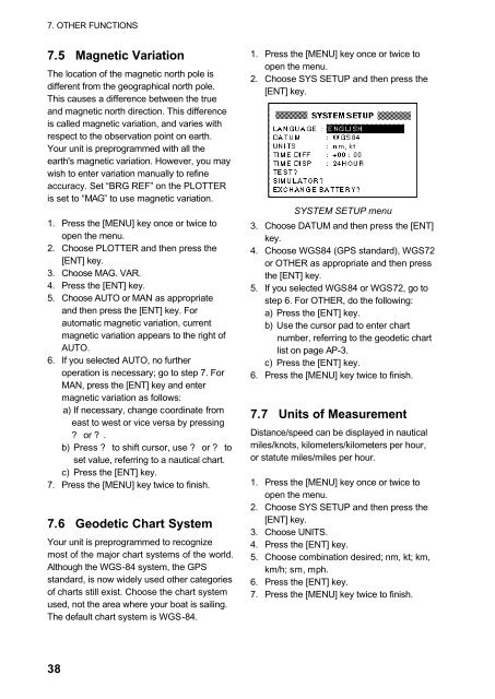
7. OTHER FUNCTIONS7.5 Magnetic VariationThe location of the magnetic north pole isdifferent from the geographical north pole.This causes a difference between the trueand magnetic north direction. This differenceis called magnetic variation, and varies withrespect to the observation point on earth.Your unit is preprogrammed with all theearth's magnetic variation. However, you maywish to enter variation manually to refineaccuracy. Set “BRG REF” on the PLOTTERis set to “MAG” to use magnetic variation.1. Press the [MENU] key once or twice toopen the menu.2. Choose PLOTTER and then press the[ENT] key.3. Choose MAG. VAR.4. Press the [ENT] key.5. Choose AUTO or MAN as appropriateand then press the [ENT] key. Forautomatic magnetic variation, currentmagnetic variation appears to the right ofAUTO.6. If you selected AUTO, no furtheroperation is necessary; go to step 7. ForMAN, press the [ENT] key and entermagnetic variation as follows:a) If necessary, change coordinate fromeast to west or vice versa by pressing? or ? .b) Press ? to shift cursor, use ? or ? toset value, referring to a nautical chart.c) Press the [ENT] key.7. Press the [MENU] key twice to finish.7.6 Geodetic Chart SystemYour unit is preprogrammed to recognizemost of the major chart systems of the world.Although the WGS-84 system, the <strong><strong>GP</strong>S</strong>standard, is now widely used other categoriesof charts still exist. Choose the chart systemused, not the area where your boat is sailing.The default chart system is WGS-84.1. Press the [MENU] key once or twice toopen the menu.2. Choose SYS SETUP and then press the[ENT] key.SYSTEM SETUP menu3. Choose DATUM and then press the [ENT]key.4. Choose WGS84 (<strong><strong>GP</strong>S</strong> standard), WGS72or OTHER as appropriate and then pressthe [ENT] key.5. If you selected WGS84 or WGS72, go tostep 6. For OTHER, do the following:a) Press the [ENT] key.b) Use the cursor pad to enter chartnumber, referring to the geodetic chartlist on page AP-3.c) Press the [ENT] key.6. Press the [MENU] key twice to finish.7.7 Units of MeasurementDistance/speed can be displayed in nauticalmiles/knots, kilometers/kilometers per hour,or statute miles/miles per hour.1. Press the [MENU] key once or twice toopen the menu.2. Choose SYS SETUP and then press the[ENT] key.3. Choose UNITS.4. Press the [ENT] key.5. Choose combination desired; nm, kt; km,km/h; sm, mph.6. Press the [ENT] key.7. Press the [MENU] key twice to finish.38