Paving the Way for Climate-Resilient Infrastructure - UN CC:Learn
Paving the Way for Climate-Resilient Infrastructure - UN CC:Learn
Paving the Way for Climate-Resilient Infrastructure - UN CC:Learn

You also want an ePaper? Increase the reach of your titles
YUMPU automatically turns print PDFs into web optimized ePapers that Google loves.
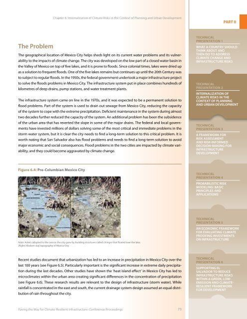
Chapter 6: Internalization of <strong>Climate</strong> Risks in <strong>the</strong> Context of Planning and Urban DevelopmentPART IIThe ProblemThe geographical location of Mexico City helps sheds light on its current water problems and its vulnerabilityto <strong>the</strong> impacts of climate change. The city was developed on <strong>the</strong> low part of a closed water basin in<strong>the</strong> Valley of Mexico on top of five lakes, and it is prone to floods. Since colonial times, lakes were dried upas a solution to frequent floods. One of <strong>the</strong> five lakes remains but continues up until <strong>the</strong> 20th Century wasto subject to regular floods. In <strong>the</strong> 1950s, <strong>the</strong> federal government undertook a major infrastructure projectto solve <strong>the</strong> floods problems in Mexico City. The infrastructure system put in place combines hundreds ofkilometres of deep drains, pump stations, and water treatment plants.The infrastructure system came on line in <strong>the</strong> 1970s, and it was expected to be a permanent solution toflood problems. Part of <strong>the</strong> system is used to drain out sewage from Mexico City, reducing <strong>the</strong> capacityof <strong>the</strong> system to cope with <strong>the</strong> extreme precipitation. Deficient maintenance in <strong>the</strong> system during almosttwo decades fur<strong>the</strong>r reduced <strong>the</strong> capacity of <strong>the</strong> system. An additional problem has been <strong>the</strong> subsidenceof <strong>the</strong> urban area that has reverted <strong>the</strong> slope in some of <strong>the</strong> major drains. The federal and local governmentshave invested millions of dollars solving some of <strong>the</strong> most critical and immediate problems in <strong>the</strong>storm water system, but it is clear <strong>the</strong> city needs to find a long-term solution to this critical problem. It isworth noting that San Salvador also has flood problems and needs to find a long-term solution to avoidmajor economic and social consequences. Flood problems in <strong>the</strong> two cities are impacted by climate variability,and <strong>the</strong>y could become aggravated by climate change.TechnicalPresentation 1What a Country ShouldThink About andThen Do to Address<strong>Climate</strong> Change and<strong>Infrastructure</strong> RisksTechnicalPresentation 2Internalization of<strong>Climate</strong> Risks in <strong>the</strong>Context of Planningand Urban DevelopmentTechnicalPresentation 3A Framework <strong>for</strong>Risk Assessmentand Risk-In<strong>for</strong>medDecision-Making <strong>for</strong><strong>Infrastructure</strong>DevelopmentFigure 6.4: Pre-Columbian Mexico CityTechnicalPresentation 4Probabilistic RiskModeling: BasicPrinciples andApplicationsTechnicalPresentation 5Note: Aztecs adapted to <strong>the</strong> area as <strong>the</strong> city grew by building structures called chinapa that floated over <strong>the</strong> lake;(Right) Modern-day topography of Mexico CityAn Economic Framework<strong>for</strong> Evaluating <strong>Climate</strong>Proofing Investmentson <strong>Infrastructure</strong>Recent studies document that urbanization has led to an increase in precipitation in Mexico City over <strong>the</strong>last 100 years (see Figure 6.5). Particularly important is <strong>the</strong> significant increase in extreme daily precipitationduring <strong>the</strong> last decades. O<strong>the</strong>r studies have shown <strong>the</strong> ‘heat island effect’ in Mexico City has led tomicroclimates within <strong>the</strong> urban area creating significant differences in <strong>the</strong> concentration of precipitation(see Figure 6.6). These research results are relevant to <strong>the</strong> design of infrastructure (storm water). Whilerainfall is concentrated in <strong>the</strong> east and south, <strong>the</strong> current drainage system design assumed an equal distributionof rain throughout <strong>the</strong> city.TechnicalPresentation 6Supporting ElSalvador to Reduce<strong>Infrastructure</strong> Riskswithin a Green, Low-Emission and <strong>Climate</strong>-<strong>Resilient</strong> Framework<strong>for</strong> Development<strong>Paving</strong> <strong>the</strong> <strong>Way</strong> <strong>for</strong> <strong>Climate</strong>-<strong>Resilient</strong> <strong>Infrastructure</strong>: Conference Proceedings 73