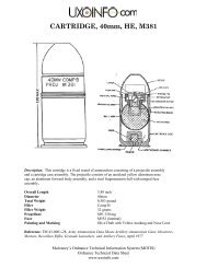
FINAL SITE INSPECTION REPORT
FINAL SITE INSPECTION REPORT
FINAL SITE INSPECTION REPORT

Create successful ePaper yourself
Turn your PDF publications into a flip-book with our unique Google optimized e-Paper software.
341342343344345346347348349350351352353354355356357358359360361362363364365366367368369370371372373374375376traverses across the western portion of the former Boardman AFR. The creek is not known tosupport fisheries. Historically the creek was dry except during periods of heavy rain and snowmelt. With the creation of Carty Reservoir and the resulting groundwater mound, water now ispresent in Sixmile Canyon Creek. The creek flows into the Columbia River, which is a majorriver that supports both federally and state threatened and listed species.2.4.7 Geologic and Hydrogeologic SettingThe former Boardman AFR lies within the Columbia Basin Subprovince of the ColumbiaIntermontane Physiographic Province.2.4.7.1 Bedrock GeologyThe bedrock beneath the Boardman AFR consists of basalt flows of the Columbia River BasaltGroup. Individual basalt flows range in thickness from a few tens of feet to several hundred feet.Interflow zones between individual flows may contain fine-grained sediments and are productivewater-bearing zones, frequently producing high volumes of water for irrigation purposes. Alayer of alluvium overlies the basalt flows and ranges in thickness from absent up to 70 feet.2.4.7.2 Overburden SoilsThe soils at the former Boardman AFR are composed of four different soil groups: the Quincyloamy fine sand, the Koehler loamy fine sand, the Hezel loamy fine sand, and the Tauton finesandy loam.2.4.7.3 HydrogeologyGroundwater occurs within two distinct aquifers, the alluvial aquifer and the Columbia RiverBasalt aquifer system. Based on documentation received from PGE and included inHydrogeology, Groundwater Chemistry, and Land Use in the Lower Umatilla BasinGroundwater Management Area (ODEQ, 1995), prior to construction of Carty Reservoir by PGEin 1977 only thin occurrences of groundwater within the alluvium were reported and SixmileCanyon Creek was dry. Leakage from Carty Reservoir has resulted in a perched groundwaterzone above the uppermost basalt flow. Water levels in the alluvium were observed to rise up to30 ft (40 ft below ground surface [bgs]) in wells constructed near Carty Reservoir. The waterlevels have now stabilized. There appears to be a groundwater mound beneath Carty Reservoir.Groundwater flow direction for both the alluvial aquifer and the Columbia River Basalt aquifersystem is to the north toward the Columbia River.There are no private irrigation wells, two industrial water source wells and several monitoringwells located within the former Boardman AFR (mostly associated with the PGE fossil fuelpower plant).2.4.8 Sensitive EnvironmentsThe ranges and other areas do qualify as Important Ecological Places (IEPs) or sensitiveenvironments as defined by USACE (2006) or EPA (1997) and shown in Table 2-2. AnBoardman AFR Final SI Report.doc 2-4 Contract No. W912DY-04-D-0010 Delivery Order No. 003September 2007