conservation area statement - Stroud District Council
conservation area statement - Stroud District Council
conservation area statement - Stroud District Council

Create successful ePaper yourself
Turn your PDF publications into a flip-book with our unique Google optimized e-Paper software.
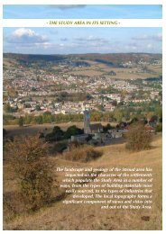
CONSERVATION AREA STATEMENT – CONSERVATION AREA NO. 16 – TOP OF TOWNGEOLOGYBetween about 185 and 140 million years ago,during the Jurassic period, a vast limestone beltwas created, stretching between Lincolnshireand the Dorset coast. The Cotswolds, a regionof ambiguous boundaries, is usually held toconstitute the highest part of this belt, a plateauthat rises from the east in Oxfordshire anddescends in a dramatic escarpment to the west,within sight of <strong>Stroud</strong>.During the Jurassic period, a shallow seacovered the <strong>area</strong>, in which a sequence ofsediments settled into alternating layers or‘strata’ of clay, sand and limestone. Althoughthe beds of sediment were each laid down on avirtually horizontal level, subsequent processeshave resulted in shifts in the terrain, so that, inplaces, strata of quite diverse ages andsubstance have ended up next to each other.The whole Cotswold plateau has been tilted,so that the west has risen up, while the east hassunk. Erosion and climatic changes have alsoplayed their part in shaping the landscape.In the past, the whole Cotswold formation wasknown as the Oolite, due to the prevalence ofthis form of limestone throughout the region.Limestone, and in particular oolitic limestone,is extremely permeable, and where it meetsbeds of impervious clay, water is driven out inthe form of springs. Hence the Cotswolds areriddled with streams and brooks as well asrivers. These have been highly active in theformation of the topography, carving deep andcomplex valleys into the ‘Oolite’ plateau, aprocess that continues and means that thelandscape is ever changing.Due to its porous nature, oolitic limestone is‘soft’ when it is newly extracted and may beeasily worked. The mass of oolite is in twobasic layers, separated by a narrow bed ofFullers Earth: the older, deeper layers beingknown as the ‘Inferior Oolite’ and the upperlayers as ‘Great Oolite’.The tilt of the Cotswolds means that the lowerlayers, the ‘Inferior Oolite’, are exposed alongthe western escarpment, where they are moreeasily accessible than in the eastern Cotswolds.The hills encircling <strong>Stroud</strong> were particularlyrich in good quality Lower Inferior Oolitestones, known by masons as ‘Freestones’, dueto the ease with which they can be cut anddressed. Among these is Lower Freestone, ofwhich the fine Painswick Stone is a variety,and Lower Limestone, the eldest of the strata,of which there is a large outcrop at FrocesterHill. Upper Freestone is of poorer quality,mostly used for burning, to create lime mortarsand plasters. At <strong>Stroud</strong>, though, it wassufficiently good to be used for many of thetown’s ‘rock-faced’ rusticated buildings.TOPOGRAPHY AND LANDSCAPEThe town of <strong>Stroud</strong> is famously located at thecentre of what is known as the ‘Five Valleys’.These comprise the valleys of the PainswickStream to the north, the Slad Brook to thenortheast, the river Frome, entering <strong>Stroud</strong>from the southeast and exiting to the west, andthe Nailsworth Valley to the south.To its north, south and east, the town issurrounded by a complex pattern of hills,valleys and coombes.The range of hills to the south of <strong>Stroud</strong>,stretching westward from those topped byRodborough Common and Selsley Common, isterminated by the distinctive form of FrocesterHill on the Cotswold escarpment. From theescarpment, the Cotswold landscape descendsto the flat plain of the Severn Vale.The peaks between the deep valleys formed bythe Frome, Slad Brook and Painswick Streamare riddled with many further valleys. Manyare carved out by the abundance of tributarystreams and brooks, as at Puckshole, where theRuscombe Brook slices southwards betweenthe hill-top villages of Whiteshill and Randwickto the north of <strong>Stroud</strong>.The topography of deep valleys, hills andwinding roads creates endlessly surprisingviews. The traveller’s sense of direction is oftenchallenged, and distant landmarks are revealedthrough vistas in unexpected places. The viewsalso create a warped sense of scale at times:from hilltop to hilltop, far away villages appearrelatively close, with expanses of countrysideor town concealed in valley bottoms or justover the crest of a hill.Page 10