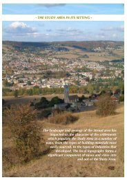
CONSERVATION AREA STATEMENT – CONSERVATION AREA NO. 16 – TOP OF TOWNThe town is not entirely encircled by hills,however. To the west of <strong>Stroud</strong>, the FromeValley broadens, opening out onto the SevernVale. The western limits of the Frome Valleyare marked by Doverow Hill on the north sideand by Frocester Hill on the south. The twohills are distinctive landmarks and frame thewestward vista towards the Severn. At its‘mouth’, the valley base is almost 3km wide(over a mile and a half).APPROACH ROUTES AND VIEWSA significant urban mass is visible on manyapproaches to the town. Yet much of thatwhich may be visually perceived as ‘<strong>Stroud</strong>’,is in fact formed by outlying villages andsettlements, which have become absorbed intothe <strong>Stroud</strong> sprawl. Notably, Rodborough,which sits prominently on a hillside to thesouthwest, lies beyond the Parish boundary.Visually, Rodborough contributes significantlyto the urban mass, yet it is in no sense part of<strong>Stroud</strong> town or parish.The original medieval core of the settlement issited on sloping ground on the lower levels of<strong>Stroud</strong> Hill, in the fork between the RiverFrome and the Slad Brook. Within this <strong>area</strong>,the Top of Town, the land rises in a west toeasterly direction. Today’s town centredescends from this, towards the Frome valleybasin, which accommodates the railway, canaland industrial <strong>area</strong>s of Wallbridge andCheapside.Being on comparatively low ground in relationto the surrounding hills, the town centre is notclearly visible from many points on approachto <strong>Stroud</strong>. In its earliest times, the settlementwould largely have been concealed within theundulating landscape. On many of the town’sapproach routes, the developed <strong>area</strong>s of <strong>Stroud</strong>Hill, Uplands and Rodborough are among thefirst discernable signals to the existence of asettlement.On a number of approaches, however, theroad arrives in the heart of town, having givenfew visual clues to the proximity of anysignificant settlement at all. This is true of thePainswick Road (A46), constructed in 1818.Until just north of the parish boundary, thetown and all high ground to the south areconcealed by trees near to the road and by thevalley. Within the boundary, the road runs lowalong the valley bottom, and from this vantagepoint there is no hint of the approachingsettlement at all. The tall trees bordering theroad at Stratford Park conceal any potentialview of built up <strong>area</strong>s to the south and west; itis only towards the termination of BeechesGreen that an urban vista opens out.A similar effect is experienced along the SladRoad from the northeast. In places, thesteepness of the valleys around <strong>Stroud</strong> hasmeant that parts of the town have avoideddevelopment and narrow fingers of green landproject into the town. Along the Slad Valley,undeveloped fields reach quite close to theheart of the town. Despite the extensivedevelopment of Uplands (to the right) and theTop of the Town above Summer Street (visibleacross the valley to the left), the effect is tocontinue the sense of the Slad Road’s dramaticrural landscape, almost to the point of arrival inthe centre of town. Rodborough Fields, to thesoutheast have similarly remained green andundeveloped.The extension of the countryside into the townthus occurs both physically and visually, thegreen horizons being visible from within thevery centre of town. This forms a verydistinctive and unusual characteristic of <strong>Stroud</strong>.There are a number of features which formstrong visual points of reference on many ofthe approaches to <strong>Stroud</strong>, some of which <strong>area</strong>lso conspicuous landmarks viewed fromwithin the town itself.Among the distinctive and most frequentlyvisible natural forms are the, alreadymentioned, Doverow Hill and the Escarpmentat Frocester and Sandford’s Knoll. These,together with the scrubby land of RodboroughCommon are glimpsed in views even from theheart of the town. Approaching from the eastand north, the River Severn is also sometimesdistantly visible beyond the town.Page 11
CONSERVATION AREA STATEMENT – CONSERVATION AREA NO. 16 – TOP OF TOWNThe unique tower of Selsley Church is amongthe most conspicuous built features of <strong>Stroud</strong>’ssetting, visible from within the town and manyplaces on approach to it.The spire of St Laurence’s Church, despitebeing on relatively low ground, is alsoprominent, especially from within the towncentre. All Saints Church in Uplands isfrequently identifiable, even from afar, itsdisproportionately large size in relation tosurrounding buildings sometimes warping anysense of scale or distance.Other highly conspicuous and less sympatheticlandmark buildings include the tower blockflats on Summer Street and the Law Courts andPolice Station building, both of which occupyextremely prominent sites on <strong>Stroud</strong> Hill. TheLaw Courts building is particularly dominant,conspicuously visible in views from almostevery approach route into the town.Page 12