conservation area statement - Stroud District Council
conservation area statement - Stroud District Council
conservation area statement - Stroud District Council

Create successful ePaper yourself
Turn your PDF publications into a flip-book with our unique Google optimized e-Paper software.
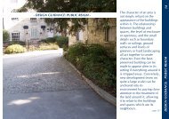
CONSERVATION AREA STATEMENT – CONSERVATION AREA NO. 16 – TOP OF TOWNPART III: STRATEGYA REVIEW OF THE CONSERVATIONAREA BOUNDARYThe character appraisal has revealed that theboundary of the <strong>Stroud</strong> Top of TownConservation Area would benefit by someconsiderable changes. The Planning Authorityproposes to redefine the boundary toincorporate the modifications shown on map6.Some minor additions and deletions arenecessary in terms of realignment of theboundary because of physical changes thathave occurred, or because the originalboundary was indecisive.However, some more substantial changes <strong>area</strong>lso considered necessary. It has been foundthat an extensive <strong>area</strong> to the east of the original<strong>Stroud</strong> Top of the Town Conservation Area ifhistorically important to the evolution of thetown.Additions:1. A major addition is to the east of theexisting boundary incorporating LowerChurchfield Road, Churchfield Road,Horns Road, Bisley Road, Belmont Roadand Mount Pleasant. These parts arehistorically important tot he evolution ofthe town and give an indication of a pastperiod of economic prosperity and rapiddevelopment. The <strong>area</strong> is compatible withthe buildings of the same period within theexisting limits of the boundary. While insome <strong>area</strong>s, such as in the vicinity ofMount Pleasant, many of the buildingshave undergone extensive alterationindividually, as a group they still conformto the pattern and scale of developmentwhich characterises the extensive buildingphase of the late 19th century in this part oftown.2. Hall to the north of Field Road – this is alate Victorian building the nature of whichconforms to the identified character.Adjustments:1. Land to the south of Corbett House – theoriginal line here was indecisive.Deletions:1. Land to the south of The Castle – this <strong>area</strong>has been subject to infill development inrecent years. This historic setting to TheCastle has been lost and is no longer ofvalue to the <strong>conservation</strong> <strong>area</strong>.2. Acre Street and Chapel Street to the northof the Area – this <strong>area</strong> has been subject toan almost total redevelopment in recentyears. The historic and conformingcharacter has been substantially lost. Theimportant buildings remaining in this <strong>area</strong>are mostly listed and therefore have theirown statutory protection. The <strong>area</strong> istherefore no longer of value to the<strong>conservation</strong> <strong>area</strong>.DEFINING ISSUES AND PRESSURESIn order to formulate effective <strong>conservation</strong>policies, which will preserve and enhance theprevailing character of the Conservation Area,it is important to assess the sorts of pressures towhich it is subject. Many of the commontrends in development or use can havenegative implications for the retention ofimportant aspects of character and architecturalintegrity.♦ The creation of hard standing and privateparking, especially in the vicinity of HornsRoad is leading to the erosion of enclosed<strong>area</strong>s and yards, the loss of gardens andtheir railings or walls. The terraces ofHorns Road are distinctive in theConservation Area, being set back from theroad, behind enclosed private <strong>area</strong>s andwith rear enclosed private <strong>area</strong>s. This is animportant feature, bridging the divisionbetween public and private space.♦ Traffic congestion and on-street parkingare problematic at times in the whole ofthe <strong>area</strong>. Problems resulting from thePage - 34 -