conservation area statement - Stroud District Council
conservation area statement - Stroud District Council
conservation area statement - Stroud District Council

You also want an ePaper? Increase the reach of your titles
YUMPU automatically turns print PDFs into web optimized ePapers that Google loves.
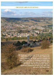
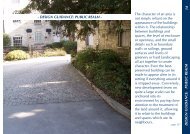
THE SPACESCONSERVATION AREA STATEMENT – CONSERVATION AREA NO. 16 – TOP OF TOWNOn the whole, the Brick Quarter is made up ofstraighter streets than the lanes of the OldTown.To the north of the sub <strong>area</strong>, the density ofbuildings decreases, many more substantialhouses being detached or semi-detached andwithin their own garden grounds. Until theearly 20th century, parts of sub <strong>area</strong> 2 wereconsiderably leafier than they are today. Manyof these have now lost their enclosure and areincreasingly being used as hard standing andparking spaces.Again, the predominant ground surface here isthe black top of the roads and pavements.Some private gardens offer a contrast to thesehard surfaces with lawns, shrubs and flowers,however the impact of this is not great as themany car parking bays have been created atthe bottom the surface of which is commonlyconcrete.The many footpaths, which dissect the <strong>area</strong>and link the terraces to the principal roads addsignificantly to the feeling of space and are animportant characteristic of the <strong>area</strong>.Tree cover is similar to that in the Old Townbeing limited to examples only being found inprivate gardens, or <strong>area</strong>s of wasteland, such asthe land to the rear of Mount Pleasant terrace.Above: Footpaths dissectingthe <strong>area</strong> create open spaceand are an importantcharacteristic of the <strong>area</strong>.Left: Some private gardensoffer a contrast to thepredominantly hard groundsurfaces.Page - 24 -