conservation area statement - Stroud District Council
conservation area statement - Stroud District Council
conservation area statement - Stroud District Council

Create successful ePaper yourself
Turn your PDF publications into a flip-book with our unique Google optimized e-Paper software.
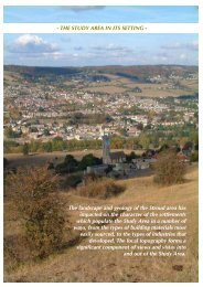
176163501112El Sub StaFBCar ParkViewSpinners House26 to 41ElSub Sta4Ladbrooke1434447ACRESTREET3446109.7m58PARLIAMENT STREET60116.1mWard BdyCRTCB120.4m157to1031PH3LBBM83.78m1 to 35High View Lodge33WESLEY COURTGospel HallWeavers House1 to 25SACitadel CitadelHouseACRE STREETWard BdyCR13 to 181112CHAPELST12 to 10312 to 1820 to 2628 to 361513Posts38 to 461748to 50QueensSquare21b 2519 21CHAPEL STREET52 to 7427 to 3337ChurchWOOD STREETFamilyCentre75111.9m1TheChestnuts24126.5m6STROUD HILL17NELSONPW157STREETPHFW31CW30aAcreHouse2419to235253HallBM 109.02mCOTTESWOLD RISE4CWWard Bdy1185.0m10CR1 to 6Blackboy86.0m1CASTLE STREETCastle Court1 to 184129BM88.63m30Ward Bdy288026 8MIDDLE STREET79GarageCastleVillasOrlyn2157890.5m2575CastleVillasFernRoyal673261243657SUTTON GARDENS33MIDDLE STREET18194372Works44454695.4mBisleyHouse(PH)67HouseBM 97.31m64656655 to 5763PICCADILLY5899.1m59El Sub Sta194Ward BdyCR6BM101.43m100.3mHOLLOW LANE104.9m1377104.9mBM107.56m11BISLEY1615ROAD102ZamekEl7<strong>Stroud</strong> ValleyCommunity School83.8mLarkhillCASTLE8STREETLB84.7m11Sub StaBM 82.55mHouse4Hemlock Well5LOWER STREET6055MelbourneHouse86.3m53851 541214BM 87.23m LOWER STREET1988.7m184219a40TheLindens37BM 90.51m3533223123191.7mBerkeleyVillas2Trinity House15BM 92.7m 93.00mTRINITY ROADHoly TrinityChurch<strong>Stroud</strong> General Hospital7 1197.8m81.7m26Waldringfield605658Corbett HouseCASTLE PITCH77.4m1to8CastleCottageTHE CASTLESPRING LANEFirCroft2HighmeadHouse3EpworthLodgeGlyfada34Hall98.1m2423Castledene4240CastleCoach House13BM 73.40mMaternity Hospital56.7m172426Castle22PitchCastle GardensCFCastlewood78.6mFIELD ROAD83.5m89.3mEl Sub Sta11a5SPRING LANELONDON ROADBM 78.69mCASTLE RISE914El Sub StaBM89.82m3STROUD TOP OF TOWN CONSERVATION AREA: SUB AREA 3 (TURN OF THE 20TH CENTURY)1:2,000This map is reproduced from Ordnance Survey material with the permission of Ordnance Survey on behalf of the Controller of HerMajesty's Stationery Office © Crown copyright. Unauthorised reproduction infringes Crown copyright and may lead to prosecutionor civil proceedings. <strong>Stroud</strong> <strong>District</strong> <strong>Council</strong> 100019682 2005This Map has been produced for <strong>Council</strong> purposes only. No further copies may be made. <strong>Stroud</strong> <strong>District</strong> <strong>Council</strong>, Ebley Mill,Westward Road, <strong>Stroud</strong>, GL5 4UB.