RESERVOIR SEDIMENTATION ASSESSMENT GUIDELINE - Aneel
RESERVOIR SEDIMENTATION ASSESSMENT GUIDELINE - Aneel
RESERVOIR SEDIMENTATION ASSESSMENT GUIDELINE - Aneel
Create successful ePaper yourself
Turn your PDF publications into a flip-book with our unique Google optimized e-Paper software.
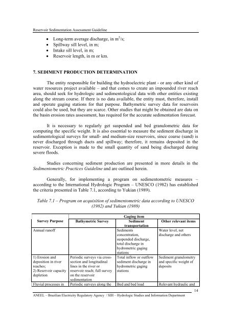
Reservoir Sedimentation Assessment Guideline• Long-term average discharge, in m 2 /s;• Spillway sill level, in m;• Intake sill level, in m;• Reservoir length, in m or km.7. SEDIMENT PRODUCTION DETERMINATIONThe entity responsible for building the hydroelectric plant - or any other kind ofwater resources project available – and that comes to create an impounded river reacharea, should seek for hydrologic and sedimentological data with other entities existingalong the stream course. If there is no data available, the entity must, therefore, installand operate gaging stations for that purpose. Bathymetric survey data for reservoirscould also be used, but they are scarce. Other studies that might be obtained are data onthe basin erosion rates assessment, has required for the accurate sedimentation forecast.It is necessary to regularly get suspended and bed granulometric data forcomputing the specific weight. It is also essential to measure the sediment discharge insedimentological surveys for small- and medium-size reservoirs, since coarse (sand) isnever discharged through ducts and spillway; therefore, it remains deposited in thereservoir. Exception is made to the small quantity of sand being discharged duringsevere floods.Studies concerning sediment production are presented in more details in theSedimentometric Practices Guideline and are outlined herein.Generally, for implementing a program on sedimentometric measures –according to the International Hydrologic Program – UNESCO (1982) has establishedthe criteria presented in Table 7.1, according to Yukian (1989).Table 7.1 – Program on acquisition of sedimentometric data according to UNESCO(1982) and Yukian (1989)Gaging itemSurvey Purpose Bathymetric Survey SedimenttransportationAnnual runoffSedimentsconcentration,suspended discharge,total discharge inhydrometric gaging1) Erosion anddeposition in riverreaches;2) Reservoir capacitydepletionPeriodic surveys via crosssectionand longitudinallines in the river orreservoir reach; full surveyon the reservoirsedimentationstationsTotal inflow or outflowsediment discharge inhydrometric gagingstationsOther relevant itemsWater level, netdischarge and othersSediment granulometryand specific weight ofdepositsFluvial processes in Periodic surveys along the Bed and bed load Relevant hydraulic andANEEL – Brazilian Electricity Regulatory Agency / SIH – Hydrologic Studies and Information Department14


