RESERVOIR SEDIMENTATION ASSESSMENT GUIDELINE - Aneel
RESERVOIR SEDIMENTATION ASSESSMENT GUIDELINE - Aneel
RESERVOIR SEDIMENTATION ASSESSMENT GUIDELINE - Aneel
Create successful ePaper yourself
Turn your PDF publications into a flip-book with our unique Google optimized e-Paper software.
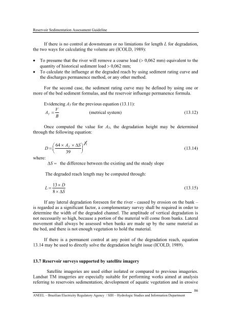
Reservoir Sedimentation Assessment GuidelineIf there is no control at downstream or no limiations for length L for degradation,the two ways for calculating the volume are (ICOLD, 1989):• To presume that the river will remove a coarse load (> 0,062 mm) equivalent to thequantity of historical sediment load > 0,062 mm;• To calculate the influenge at the degraded reach by using sediment rating curve andthe discharges permanence method, or any other method.For the second case, the sediment rating curve may be defined by using one ormore of the bed sediment formulas, and the reservoir influenge permanence formula.Evidencing A T for the previous equation (13.11):VAT = (metrical system) (13.12)BOnce computed the value for A T , the degradation height may be determinedthrough the following equation:where:D =⎛⎜⎝64 × AT× ΔS⎞⎟39 ⎠1 2ΔS = the difference between the existing and the steady slope(13.14)The degraded reach length may be computed through:13 × DL =8 × ΔS(13.15)If any lateral degradation foreseen for the river - caused by erosion on the bank –is regarded as a significant factor, a complementary survey shall be required in order todetermine the width of the degraded channel. The amplitude of vertical degradation isnot necessarily so high, because a portion of the material will come from banks. Lateralmovement shall always be assessed when banks are made up by the same material asthe bed, and there is not enough vegetation to hold the material.If there is a permanent control at any point of the degradation reach, equation13.14 may be used to directly solve the degradation height issue (ICOLD, 1989).13.7 Reservoir surveys supported by satellite imagerySatellite imageries are used either isolated or compared to previous imageries.Landsat TM imageries are especially suitable for performing works aimed at analysisreferring to reservoirs sedimentation; development of aquatic vegetation and in erosiveANEEL – Brazilian Electricity Regulatory Agency / SIH – Hydrologic Studies and Information Department86


