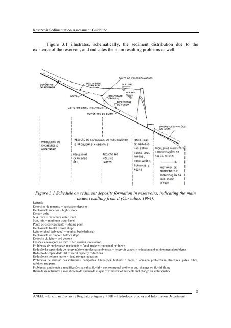
Reservoir Sedimentation Assessment GuidelineFigure 3.1 illustrates, schematically, the sediment distribution due to theexistence of the reservoir, and indicates the main resulting problems as well.Figure 3.1 Schedule on sediment deposits formation in reservoirs, indicating the mainissues resulting from it (Carvalho, 1994).Legend:Depósitos de remanso = backwater depositsDeclividade superior = higher slopeDelta = deltaN.A. max = maximum water levelN.A. min = minimum water levelPonto de escorregamento = sliding pointDeclividade frontal = front slopeLeito original (talvegue) = original bed (thalweg)Declividade de fundo = bottom slopeDepósito do leito = bed depositErosões, escavações no leito = bed erosion, excavationProblemas de enchentes e ambientais = flood and environmental problemsRedução da capacidade do reservatório e problemas ambientais = reservoir capacity reduction and environmental problemsRedução de capacidade útil = useful capacity reductionsRedução no volume morto = dead storage reductionProblemas de abrasão nas estruturas, comportas, tubulações, turbinas e peças = abrasion problems in structures, gates, tubes,turbines and partsProblemas ambientais e modificações na calha fluvial = environmental problems and changes on fluvial flumeRetirada de nutrientes e modificação da qualidade d’água = withdraw of nutrients and change on water qualityANEEL – Brazilian Electricity Regulatory Agency / SIH – Hydrologic Studies and Information Department8
Reservoir Sedimentation Assessment GuidelineOther problems deriving from sediments deposition may be noticed, and all ofthem require study and present distinct environmental impacts (Carvalho, 1994).Marginal deposits of fine sediments along stream and in the reservoir mayfacilitate the growth of aquatic plants, which are removed by the raise in water level.That fluctuating vegetation will cause several problems, such as its decomposition,deposition at the lake bottom and transformation into minerals, in addition to thesedimentation. Part of the vegetation will reach intakes, thus jeopardizing the operation,if they are not removed.Those sediments covering the bottom of the lake shall cause changes on bothfauna and flora of the bed. The clean water that flows towards the dam downstream,already without the nutrients carried sediments, shall cause changes on fauna and flora,with environmental impacts along the whole stream, specifically at the outfall. Theformation of estuary and delta at the sea may undergo severe environmental changes(Carvalho, 1994).4. THE RELEVANCE OF THE <strong>SEDIMENTATION</strong> <strong>ASSESSMENT</strong> SURVEYSedimentological studies must be carried out along all project stages, sinceplanning (inventory, feasibility and basic project) until the operation stage. During theinventory, if there are no gaging stations for measuring the sediment load, one or severalgaging stations are installed and operated, thus building up a sedimentometric network,which will be as large as the drainage area, and follow the importance of this study.The studies show that there are several kinds of approaches for the distinctstages of a reservoir project. As more serious the problems concerning erosion,sediments transportation and sedimentation presented are, either at stream or regionally,more detailed those approaches will be presented. Studies are carried out forestablishing the best sediment control measures that should be adopted.In any stage o the studies, the first steps are (Carvalho, 1994):• Survey on basin erosion conditions (soil management, deforestation, etc.);• Survey on existing or deactivated sedimentometric gaging stations;• Existing studies on the theme for the basin;• Collection of the required hydrologic and sedimentological data (series ofdischarges, sediment discharge, granulometry for suspended sediment and bed load andothers).In face of the lack of sedimentometric and hydrologic data, there is the need ofinstalling and running, in short time, a hydrological-sedimentometric gaging station ornetwork.The surveys to be performed concerning sedimentation forecast are as follows:ANEEL – Brazilian Electricity Regulatory Agency / SIH – Hydrologic Studies and Information Department9