RESERVOIR SEDIMENTATION ASSESSMENT GUIDELINE - Aneel
RESERVOIR SEDIMENTATION ASSESSMENT GUIDELINE - Aneel
RESERVOIR SEDIMENTATION ASSESSMENT GUIDELINE - Aneel

You also want an ePaper? Increase the reach of your titles
YUMPU automatically turns print PDFs into web optimized ePapers that Google loves.
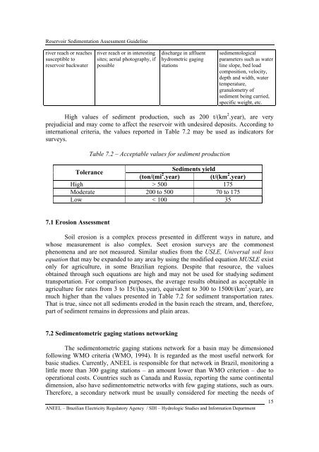
Reservoir Sedimentation Assessment Guidelineriver reach or reachessusceptible toreservoir backwaterriver reach or in interestingsites; aerial photography, ifpossibledischarge in affluenthydrometric gagingstationssedimentologicalparameters such as waterline slope, bed loadcomposition, velocity,depth and width, watertemperature,granulometry ofsediment being carried,specific weight, etc.High values of sediment production, such as 200 t/(km 2 .year), are veryprejudicial and may come to affect the reservoir with undesired deposits. According tointernational criteria, the values reported in Table 7.2 may be used as indicators forsurveys.Table 7.2 – Acceptable values for sediment productionToleranceSediments yield(ton/(mi 2 .year) (t/(km 2 .year)High > 500 175Moderate 200 to 500 70 to 175Low < 100 357.1 Erosion AssessmentSoil erosion is a complex process presented in different ways in nature, andwhose measurement is also complex. Seet erosion surveys are the commonestphenomena and are not measured. Similar studies from the USLE, Universal soil lossequation that may be expanded to any area by using the modified equation MUSLE existonly for agriculture, in some Brazilian regions. Despite that resource, the valuesobtained through such equations are high and may not be used for studying sedimenttransportation. For comparison purposes, the average results obtained as acceptable inagriculture for rates from 3 to 15t/(ha.year), equivalent to 300 to 1500t/(km 2 .year), aremuch higher than the values presented in Table 7.2 for sediment transportation rates.That is true, since not all sediments eroded in the basin reach the stream, and, therefore,part of sediment remains in depressions and plain areas.7.2 Sedimentometric gaging stations networkingThe sedimentometric gaging stations network for a basin may be dimensionedfollowing WMO criteria (WMO, 1994). It is regarded as the most useful network forbasic studies. Currently, ANEEL is responsible for that network in Brazil, monitoring alittle more than 300 gaging stations – an amount lower than WMO criterion – due tooperational costs. Countries such as Canada and Russia, reporting the same continentaldimension, also have sedimentometric networks with few gaging stations, such as ours.Therefore, a secondary network must be usually considered for meeting the needs ofANEEL – Brazilian Electricity Regulatory Agency / SIH – Hydrologic Studies and Information Department15