RESERVOIR SEDIMENTATION ASSESSMENT GUIDELINE - Aneel
RESERVOIR SEDIMENTATION ASSESSMENT GUIDELINE - Aneel
RESERVOIR SEDIMENTATION ASSESSMENT GUIDELINE - Aneel

You also want an ePaper? Increase the reach of your titles
YUMPU automatically turns print PDFs into web optimized ePapers that Google loves.
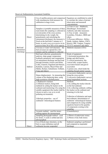
Reservoir Sedimentation Assessment GuidelineBed loadentrainment dischargeDirectIndirectDirectUse of satellite pictures and comparisonwith simultaneous field measures forcalibration in large rivers.Samplers or portable measurers of threemain kinds (the sampling is collected inseveral points of the cross-section,determining its dry weight, thegranulometry and calculating theentrainment discharge); the measurer isfixed on the bed from 2 minutes to 2hours, in such a way as to receive in itsreceiver from 30 to 50% of its capacityCrevasse or water well structures – thebed crevasses are opened for a fewminutes and the sediment is collectedBed load collection, granulometricanalysis, slope gauge, temperaturehydraulic parameters and computationon entrainment discharge and bed loadthrough formulas (Ackers and White,Colby, Einstein, Engelund and Hansen,Kalinske, Laursen, Meyer-Peter andMuller, Rottner, Schoklitsch, Toffaleti,Yang and others)Dunes displacement – by measuring thevolume of the displacing dune, usinghigh-resolution echobathymeter1) Radioactive trackers2) Dilution trackers, being bothmethods by setting the tracker on thesediment and monitoring it by using thesuitable equipment (the tracker shall bechosen in such a way as to avoidpolluting environment)Lithologic properties – use ofsediments’ mineralogical featuresAcoustic method – used for stonesstriking against the measurementSampling photograph method – usedfor stones. A scale is settled and alsophotographedUse of block-type structures, on thebed, to cause turbulence and allsediments become suspendedEquations are established in orderto correlate the values of pictureobservation and measuredconcentrations1) Crate or case - Muhlhofer,Ehrenberger, SwitzerlandAuthority and other measurers2) Tray or tank – measurersLosiebsky, Polyakov, SRIH andothers3) Pressure difference –Helley-Smith, Arnhem, Sphinx, USCE,Károlyi, PRI, Yangtze, Yangtze-78 VUV measurers and othersMulhofer measurer (USA)Kinds of equipment:1) horizontal penetration, likedredge and shell bucket2) vertical penetration, likevertical tube, scraper bucket,excavation bucket and gravelexcavation3) piston-core, which holds thesampling though partial vacuum1) successive bathymetric surveysalong the cross-section2) successive bathymetric surveysalong longitudinal sectionsMethods:1) by settling the tracker directlyon the bed sediment2) by collecting sediment, settlingthe tracker on the sediment andreturning it to the bed.Collection of tributaries and mainbed sediment, determination ofsediments’ mineralogical featuresand comparison by using suitableequations based on the quantityof components existing in thesampling(Unsatisfactory)1) Photos of underwater stones2) Photos of dry beds stonesSediment sampling is performedand computed as suspendeddischargeANEEL – Brazilian Electricity Regulatory Agency / SIH – Hydrologic Studies and Information Department18