RESERVOIR SEDIMENTATION ASSESSMENT GUIDELINE - Aneel
RESERVOIR SEDIMENTATION ASSESSMENT GUIDELINE - Aneel
RESERVOIR SEDIMENTATION ASSESSMENT GUIDELINE - Aneel

Create successful ePaper yourself
Turn your PDF publications into a flip-book with our unique Google optimized e-Paper software.
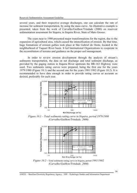
Reservoir Sedimentation Assessment Guidelineseveral years, and their respective average discharges, one can calculate the rate ofincrease for sediment transportation, by using the mass curve. An illustrative example ispresented, taken from the work of Carvalho/Guilhon/Trindade (2000) on reservoirsedimentation assessment for Itiquira, in Itiquira River, State of Mato Grosso.The years near to 1980 presented major transformations for the region, due to theexpansion of agricultural area, which caused the intensification of erosion. By that time,huge formations of erosion gullies took place at São Gabriel do Oeste, located in theneighborhood of Taquari River basin. It led International Organizations to cooperate inthe reconstitution of terrains and guidance on the proper soil management.In order to review erosion development through the analysis of stream’ssediments transportation, the data on net discharge and total sediment discharge, asprovided by the gaging station in Itiquira River upstream the BR-163 Highway wereused. Two sediments rating curves were prepared, being the first one for the years1979/1980 (Figure 10.1) and the second one for the years 1981/1982 (Figure 10.2). It isrecommended to have data enough in order to provide rating curves as accurate asdesired, preferably for each year.10,0001,000Qst = 2029,4Ln(Q) - 6286,3R 2 = 0,320310010 100 1000Net Discharge (m³/s)Figure 10.1 – Total sediments rating curve in Itiquira, period 1979/1980(Carvalho/Guilhon/Trindade, 2000)10,0001,000Qst = 4130,6Ln(Q) - 13842R 2 = 0,660110010 100 1000Net Discharge (m ³/s)Figure 10.2 - Total sediments rating curve in Itiquira, period 1981/1982(Carvalho/Guilhon/Trindade, 2000)ANEEL – Brazilian Electricity Regulatory Agency / SIH – Hydrologic Studies and Information Department50